Village

Clifford

A castle above a Wye crossing anchors Clifford’s story, but its hilltop church, former priory and chapel reveal a wider parish of farms and scattered communities.

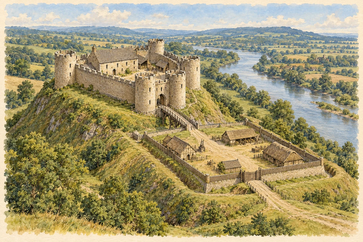
Watercolour and fine ink historical reconstruction of Clifford Castle above the River Wye, c. 1250
Historical reconstruction · Clifford Castle above the River Wye · c. 1250
Original illustration; researched sources
Research sources

Original interpretation of the surveyed medieval plan.

Herefordshire Archaeology: Clifford Castle repairs report; Clifford Castle: history

Artistic reconstruction · c. 1250

Clifford Castle c.1250, reconstructed from its surveyed plan. Restored heights, roofs and timber access are interpretive.

Evidence and interpreted details

Uncertain details: Wall heights and parapets are interpreted. Roofs, bridge and bailey details are conjectural.

Based on: Herefordshire Archaeology: Clifford Castle repairs report

History & heritage

Place & story

A crossing and an imposed stronghold

Clifford Castle stands on the east bank of the Wye, above a ford identifiable northwest of its earthworks. Historic England’s survey places its foundation between the Norman Conquest and William Fitz Osbern’s death in 1071. Domesday records both castle and borough in 1086, although the borough’s precise position remains uncertain. The castle was an administrative centre as well as a military stronghold. [2]

A parish beyond the castle

The parish’s settlements were dispersed. Simon fitz Richard founded a Cluniac priory around 1129; a later farm occupies its site. The village lies near the castle, while St Mary’s stands on a separate hilltop. Priory Wood forms another settlement whose pattern the archaeological survey interprets as probable encroachment on common land. [2]

St Mary’s changing fabric

St Mary’s contains evidence of successive congregations rather than one building campaign. Its origins reach into the twelfth century, with nave and chancel of about 1300 and an eighteenth-century west tower. Restorations followed in 1839 and 1888. The latter, by Ewan Christian, added the north aisle, porch and organ chamber, expanding the medieval church’s space for worship and music. [3]

A chapel at Priory Wood

The Calvinistic Methodist chapel near Priory Wood carries an 1827 datestone. Herefordshire’s heritage account describes a simple rubble-stone building with round-headed windows. A later nineteenth-century rearrangement placed the pulpit in a raised enclosure at the west end. Its surviving fabric, although no longer used as a chapel, records a religious community distinct from the parish church. [4]

Back to contents
Lives connected to this place

Notable people

Rosamund Clifford: a family connection beneath the legend

Rosamund was the daughter of Walter Clifford I and became Henry II’s mistress. Her connection with the castle’s ruling family helped make the ruin a subject of later romantic fascination. Historic England’s survey separates that relationship from unsubstantiated stories of a labyrinth at Woodstock and a fatal confrontation with Queen Eleanor. [2]

Thomas William Webb: observing from Hardwicke

Hardwicke, historically part of the larger Clifford parish, was the setting for clergyman and astronomer Thomas William Webb’s observatory. The Society for the History of Astronomy dates it to 1866–85 at the rectory. A nine-inch reflecting telescope made by With stood on a Berthon-type mount inside a twelve-sided wooden structure with a canvas roof. This is a connection to the wider historic parish, rather than a claim that Webb worked in Clifford village. [5] [2]

Back to contents
A chronology

Timeline

Clifford through time

  1. 1066–71 — William Fitz Osbern establishes the castle. [2]

  2. 1086 — Domesday records Clifford’s castle and borough. [2]

  3. Around 1129 — Simon fitz Richard founds the Cluniac priory. [2]

  4. Around 1300 — The surviving nave and chancel of St Mary’s take shape. [3]

  5. 1827 — The Calvinistic Methodist chapel is dated at Priory Wood. [4]

  6. 1866–85 — Webb’s observatory operates at Hardwicke rectory. [5]

  7. 1888 — Ewan Christian’s restoration enlarges St Mary’s. [3]

Back to contents

Population over time

A verified population series for Clifford as a settlement has not yet been added. Neighbourhood census figures are available below.

Neighbourhood census context

These figures describe statistical neighbourhoods, which may cover part of a place or include neighbouring places.

Neighbourhood census area · 1971–2021

Herefordshire 020

Population of the area containing the recorded point for Clifford, not the whole place. This area may cover part of the place or include neighbours.

01.8k3.5k5.3k7k1971: 4,630 people19711981: 5,059 people19811991: 5,253 people19912001: 5,811 people20012011: 6,067 people20112021: 6,060 people2021

Includes harmonised historical census estimates.

Sources: ONS · Paul Norman

View population figures
Herefordshire 020 — census population and harmonised historical estimates
Census yearPopulation
19714,630
19815,059
19915,253
20015,811
20116,067
20216,060
Sources and how to read this chart

Usual residents of the containing MSOA; this is local area context, not the population of the named settlement.. Boundary geography: 1 April 2022 (E02002924).

2011 and 2021 census counts harmonised by ONS to the same 1 April 2022 geography. Location matched to ONS 2021 MSOA polygons (full resolution, coastline clipped, V7). ONS exact-fit lookup marks this MSOA unchanged from 2011 (U); historical estimates use that same footprint.

1971–2011: Paul Norman harmonised historical estimates on 2011 MSOAs, rounded to whole residents (1971–1991 are modelled). 2021: ONS census count. The historical 2011 total can differ slightly from the ONS change-over-time 2011 total because of methodology and statistical disclosure controls. These are area estimates, not settlement totals.

Source: ONS Census change over time: usual resident population, 2011 and 2021. Open Government Licence v3.0. Retrieved 2026-10-26. Source: ONS MSOA December 2021 boundaries EW BFC V7. Open Government Licence v3.0. Retrieved 2026-10-26. Source: Paul Norman — Area characteristics: Great Britain 1971 to 2011. Creative Commons Attribution 4.0. Retrieved 2026-10-26. Source: ONS MSOA 2011 to MSOA 2021 exact-fit lookup for England and Wales. Open Government Licence v3.0. Retrieved 2026-10-26.

Recorded locationClifford52.10425° N · 3.10255° WInteractive map loads when this area enters view.
Approximate recorded location · Geographic source

Geographic context

Place type
Village
Country / region
England · West Midlands
County group
Herefordshire
Current administration
County of Herefordshire
Recorded coordinates
52.10425, -3.10255
OS Open Names ID
osgb4000000074578713

County groups are browsing aids. Current administrative and historic areas are recorded separately.

Recorded names

  • Clifford · en · official

Nearby heritage

Distances are from the recorded place point. Proximity does not establish that a site lies within the place boundary or belongs to its history.

Sources & further reading

  1. OS Open Names October 2026 · Source licence.
  2. Clifford Castle: Archaeological, Architectural and Aerial Investigation and Survey, report 69/2018 · Historic England
  3. Church of St Mary, list entry 1348871 · Historic England
  4. Herefordshire Through Time: Chapels, Clifford entries · Herefordshire Council
  5. Observatories: Herefordshire · Society for the History of Astronomy
  6. Original illustration of Clifford Castle above the River Wye by PlaceHistory. Researched sources are linked beneath the illustration. Original evidence-based historical reconstruction; restored heights, roofing, timber access and bailey detail are interpretive and disclosed in the note.

Geographic source retrieved 2026-10-26. History last researched 2026-10-26. How this page was prepared.