Village

Eardisley

Eardisley’s long village street grew beside castle and church; a richly carved font and the memory of a horse tramway reveal different kinds of connection beyond the village.

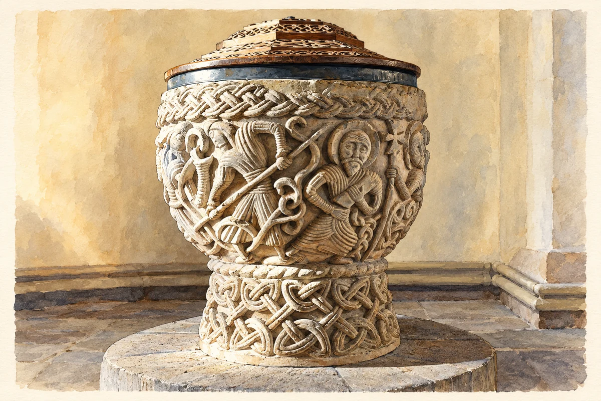
Watercolour and fine ink illustration of Eardisley church Romanesque font
Illustration · Eardisley church Romanesque font
History & heritage

Place & story

A village laid out for trade

The neighbourhood plan describes Eardisley as a medieval settlement organised around its castle and church. A market and fair were granted about 1225, and long, narrow tenement plots were laid out at right angles to the main road during the thirteenth century. Those plots helped establish the linear shape of the village. Timber-framed buildings therefore stand within a street pattern with a history older than many of the houses. [3]

The castle belonged to a contested border landscape. The county’s archaeological account records a fortified house in the Domesday entry and a castle by 1183. In 1263 Roger de Clifford imprisoned Peter de Aquablanca, Bishop of Hereford, here. The surviving mound and wet ditches represent a stronghold whose buildings have largely disappeared. [4]

A font within a changing church

St Mary Magdalene has twelfth-century origins but was repeatedly enlarged and altered. Its carved font is dated by Historic England to the middle of that century. Interlaced bands surround relief scenes including a lion, fighting men and the Harrowing of Hell. This was a complex visual object in a working parish church, rather than an isolated piece of sculpture. [5]

The Corpus of Romanesque Sculpture compares the font particularly closely with Castle Frome’s: shape, scale and carving suggest the same sculptor. It also relates the scenes to work elsewhere in the Herefordshire School. Such comparisons place Eardisley within a network of medieval patronage and skilled stone carving. [6]

Later work changed the setting around the font. The aisles and chancel developed during the thirteenth and fourteenth centuries; the north-west tower was rebuilt in the early eighteenth century. Both Historic England and the Corpus record extensive Victorian restoration, although they give adjacent years for it. [5] [6]

Fuel arrives on rails

Tram Square preserves the name of the horse-drawn route that brought Welsh coal to Eardisley. It belonged to a transport system for heavy goods: the county’s transport history dates the parliamentary authorisation to 1811 and completion from the Brecon canal to Eardisley to 1818. Coal, iron, lime and corn were among its intended loads. [2] [7]

The route continued to Kington in 1820. Steam railways later replaced this earlier technology, but their dates should be distinguished: Eardisley’s first railway arrived in 1864, while the Kington and Eardisley line opened in 1874. Littlebury’s 1876–77 directory explicitly calls the latter newly opened. Transport made the village a junction between different routes and successive technologies. [7] [3] [10]

Learning beside the older institutions

Eardisley’s school dates its foundation to 1857 and records that its original buildings remain in use, adapted for modern education. Beside the better-known medieval monuments, it offers a different form of continuity: a nineteenth-century institution that has changed its rooms and teaching while remaining part of village life. [9]

Back to contents
Lives connected to this place

Notable people

George Coke: a displaced bishop at Lower Moor

The nineteenth-century Imperial Gazetteer records that George Coke, Bishop of Hereford, lived and died at his seat of Lower Moor. His connection belongs to the wider Eardisley parish rather than necessarily the village street. Historic England records a brass commemorating him, with his death dated 1646, in the church nave. [8] [5]

Back to contents
A chronology

Timeline

Eardisley through time

  1. 1086 — Domesday records a fortified house at Eardisley. [4]

  2. Mid-twelfth century — The church font is carved. [5]

  3. About 1225 — A market and fair are granted. [3]

  4. 1263 — Roger de Clifford imprisons the Bishop of Hereford at the castle. [4]

  5. 1818 — The horse tramroad reaches Eardisley from the canal at Brecon. [7]

  6. 1857 — The school dates its foundation to this year. [9]

  7. 1864 — Steam railway reaches Eardisley. [3]

  8. 1874 — The Kington and Eardisley Railway opens. [10]

Back to contents

Population over time

A verified population series for Eardisley as a settlement has not yet been added. Neighbourhood census figures are available below.

Neighbourhood census context

These figures describe statistical neighbourhoods, which may cover part of a place or include neighbouring places.

Neighbourhood census area · 1971–2021

Herefordshire 006

Population of the area containing the recorded point for Eardisley, not the whole place. This area may cover part of the place or include neighbours.

02k4k6k8k1971: 6,716 people19711981: 6,893 people19811991: 7,044 people19912001: 7,807 people20012011: 7,875 people20112021: 7,850 people2021

Includes harmonised historical census estimates.

Sources: ONS · Paul Norman

View population figures
Herefordshire 006 — census population and harmonised historical estimates
Census yearPopulation
19716,716
19816,893
19917,044
20017,807
20117,875
20217,850
Sources and how to read this chart

Usual residents of the containing MSOA; this is local area context, not the population of the named settlement.. Boundary geography: 1 April 2022 (E02002910).

2011 and 2021 census counts harmonised by ONS to the same 1 April 2022 geography. Location matched to ONS 2021 MSOA polygons (full resolution, coastline clipped, V7). ONS exact-fit lookup marks this MSOA unchanged from 2011 (U); historical estimates use that same footprint.

1971–2011: Paul Norman harmonised historical estimates on 2011 MSOAs, rounded to whole residents (1971–1991 are modelled). 2021: ONS census count. The historical 2011 total can differ slightly from the ONS change-over-time 2011 total because of methodology and statistical disclosure controls. These are area estimates, not settlement totals.

Source: ONS Census change over time: usual resident population, 2011 and 2021. Open Government Licence v3.0. Retrieved 2026-10-26. Source: ONS MSOA December 2021 boundaries EW BFC V7. Open Government Licence v3.0. Retrieved 2026-10-26. Source: Paul Norman — Area characteristics: Great Britain 1971 to 2011. Creative Commons Attribution 4.0. Retrieved 2026-10-26. Source: ONS MSOA 2011 to MSOA 2021 exact-fit lookup for England and Wales. Open Government Licence v3.0. Retrieved 2026-10-26.

Recorded locationEardisley52.14094° N · 3.01242° WInteractive map loads when this area enters view.
Approximate recorded location · Geographic source

Geographic context

Place type
Village
Country / region
England · West Midlands
County group
Herefordshire
Current administration
County of Herefordshire
Recorded coordinates
52.14094, -3.01242
OS Open Names ID
osgb4000000074579656

County groups are browsing aids. Current administrative and historic areas are recorded separately.

Recorded names

  • Eardisley · en · official

Nearby heritage

Distances are from the recorded place point. Proximity does not establish that a site lies within the place boundary or belongs to its history.

Sources & further reading

  1. OS Open Names October 2026 · Source licence.
  2. Black & White Villages · Visit Herefordshire
  3. Eardisley Group Neighbourhood Development Plan, submission May 2015 · Eardisley Group Parish Council / Herefordshire Council
  4. Eardisley Castle · Herefordshire Council, Herefordshire Through Time
  5. Church of St Mary Magdalene: 1349544 · Historic England
  6. St Mary Magdalene, Eardisley · George Zarnecki and Ron Baxter / CRSBI
  7. Transport overview · Herefordshire Council, Herefordshire Through Time
  8. Eardisley: Imperial Gazetteer 1870–72 · John Marius Wilson / GB Historical GIS, University of Portsmouth
  9. School prospectus · Eardisley CE Primary School
  10. Eardisley, Littlebury’s Directory and Gazetteer 1876–77 · Littlebury / transcribed by Marion B. Wilkinson
  11. Illustration of Eardisley church Romanesque font, adapted from Font, Eardisley church - geograph.org.uk - 2786863.jpg by Philip Halling. CC BY-SA 2.0. AI-assisted watercolour and fine ink adaptation; incidental clutter simplified, warm cream paper margins. Architectural forms follow the inspected reference.

Geographic source retrieved 2026-10-26. History last researched 2026-10-26. How this page was prepared.