City

Hereford

Hereford grew around a Wye crossing, a cathedral and a market. Its earthworks, medieval books, timber-framed shops and former cider factory reveal a city shaped by defence, learning and exchange with the surrounding countryside.

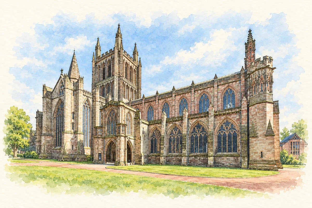
Watercolour and fine ink illustration of Hereford Cathedral
Illustration · Hereford Cathedral
History & heritage

Place & story

Finding the Saxon city beneath the streets

Hereford's history begins with a settlement beside a crossing of the River Wye. The name is explained as 'army-ford' in the council's account of its Saxon origins. Archaeology provides more tangible evidence of an early defended town. Excavations in Victoria Street in 1968 exposed successive pre-Conquest ramparts; the earliest gravel bank lay above grain-drying ovens with a radiocarbon date centred on AD 761. That date belongs to the activity below the defences, rather than an exact year for building the bank. [3]

Other discoveries bring the people within the defences into view. In Berrington Street, excavators found the remains of two Saxon timber buildings, pottery and a coin of Alfred. The evidence is fragmentary, disturbed by later pits, but shows that the town's early story is preserved beneath its later streets as well as in written accounts. Hereford's position combined a river crossing, religious institutions and a defended place in which trade could develop. [3] [4]

A market alongside the cathedral

By the Domesday survey, Hereford was a regional centre of government, religion and commerce. The council's account of Saxon Herefordshire notes sheep, honey and salmon among its recorded goods, and a customary payment from women who brewed ale. These details place agriculture, fishing and household production within the city's economy. Its churches attracted a community in which traders and craftsmen could find customers. [4]

The Norman town expanded beyond the earlier defended core. William fitz Osbern developed land to the north of the Saxon wall, while settlers from Normandy were offered burgage plots and relief from customary dues. Their street, Frenschemanne Lane, survives in the modern name Bewell Street. The city was therefore shaped both by growth around older institutions and by deliberate decisions about streets, property and the terms on which newcomers could settle. [5]

Destruction, rebuilding and daily worship

Worship on the cathedral site is documented from at least the eighth century. The cathedral was destroyed in the attack on Hereford in 1055; rebuilding between 1107 and 1148 produced the Romanesque architecture that is the earliest style still visible there. The medieval institution was governed by secular priests, rather than monks. Its Vicars Choral lived a collegiate life and sang the daily services, making the cathedral a workplace and community as well as a monumental building. [2]

Rebuilding did not end in the Middle Ages. The west tower collapsed on Easter Monday in 1786, and major restoration followed in the nineteenth century. The building seen today is the result of repeated repair and alteration. Its long-lived collections offer another kind of continuity: books and manuscripts survived changes that transformed the architecture around them. [2] [7]

Reading a medieval world

The Mappa Mundi, dated to about 1300, presents a world organised around Christian understanding rather than modern mapping conventions. Jerusalem occupies its centre. Drawn on a single calfskin, it combines places with biblical scenes, animals, peoples and classical stories. Its interest lies in that combination: geography, history and belief occupy the same surface. It offers an unusually rich view of how a medieval audience could imagine a world beyond Hereford. [6]

In the Chained Library, the physical arrangement explains how books were used and protected. Chains connect their front covers to rods along the shelves, allowing reading at a desk while preventing removal. The foredges face outwards so that a volume can be opened without tangling its chain. The collection includes 229 medieval manuscripts, among them the eighth-century Hereford Gospels. Its present chamber displays the library's arrangement of 1611–1841 while providing controlled conditions for the books. [7]

A butcher's home in High Town

The timber-framed Old House, also known as the Black and White House Museum, was built in 1621 as a butcher's shop and residence. It later housed other businesses and a bank before becoming a museum in 1929. The county archive describes a photograph from about 1879 showing it as a hardware shop. The image is a useful corrective to treating an old building as belonging only to the period in which it was built: this house continued to work in the changing commercial city. [8] [9]

Hereford's livestock market was part of this commercial landscape. In the 1850s the cattle market moved out of the central streets to the area between New Market Street and Blackfriars Street. Later enlargements recorded in the city's historic-area assessment show its continuing importance. Market space changed, but the relationship between Hereford and its agricultural hinterland remained a working part of the city. [10]

The demands of a defended city

During the Civil War, defence imposed demands on residents as well as soldiers. In 1644 the king authorised Hereford's governor to compel military service, take arms, quarter troops and levy contributions. Gates were strengthened, fixed bridges replaced by drawbridges, and buildings outside the walls removed so that an enemy could not use them. Security for the Royalist garrison could mean lost buildings, supplies and freedom for others. [11]

A Scottish army fighting for Parliament began its siege on 31 July 1645. The city resisted through weeks of bombardment, mining and sorties; accounts describe townspeople repairing breaches under fire. The army eventually withdrew, but Hereford was captured for Parliament that December. Its walls were therefore both instruments of defence and the focus of a struggle that reached deeply into everyday urban life. [11] [12]

Turning an industry into a collection

The Museum of Cider occupies a former Bulmer's factory, linking the city's industrial buildings to the orchards beyond it. Its origins were an act of preservation: Bertram Bulmer and Norman Weston feared that the history of cider making was being lost. Their trust was founded in 1973, and staff and volunteers collected objects and archives before the museum opened in 1981. Equipment and business records could become historical evidence when an industry changed. [13]

Back to contents
Lives connected to this place

Notable people

Thomas Cantilupe: a bishop and a pilgrimage centre

Thomas Cantilupe served as bishop of Hereford and died in Italy in 1282 while appealing against excommunication. His bones were returned to the city, where reports of miracles drew pilgrims to his tomb; he was canonised in 1320. These were claims of devotion, rather than independently established cures. His posthumous following shaped the cathedral's spaces, including the north transept and a later Lady Chapel shrine destroyed at the Reformation. The surviving monument connects an individual bishop with the movement of pilgrims through the city. [14] [2]

Brian Hatton: a local landscape in drawings

Brian Hatton was born in Hereford in 1887 and grew up at Whitecross and later Broomy Hill. He sketched the countryside around his home, including horses, farm work and local people, before developing a professional portrait practice in London. Killed while serving in Egypt in 1916, he left a body of work now substantially represented in Hereford Museum. The collection preserves both an artist's development and his close observation of the landscape around the city. [15]

Bertram Bulmer and Norman Weston: preserving cider history

Bulmer and Weston both came from cider-making families and turned that connection into a museum project in Hereford. Their work brought industrial objects and archives into a former factory rather than leaving them dispersed or discarded. Bulmer also established the museum's King Offa Distillery, obtaining a licence in 1984 after a dispute over producing cider brandy. The preserved distillery records a practical attempt to revive a craft alongside the work of collecting its history. [13]

Back to contents
A chronology

Timeline

Hereford through time

  1. 1055 — The cathedral is destroyed during an attack on Hereford. [2]

  2. 1107–48 — Romanesque rebuilding creates the earliest architectural style visible in the cathedral today. [2]

  3. c.1300 — The Mappa Mundi is made, combining geography, history and belief on a single calfskin. [6]

  4. 1320 — Thomas Cantilupe is canonised, confirming the status of the bishop whose tomb attracts pilgrims. [14]

  5. 1621 — The Old House is built as a butcher's shop and home. [8]

  6. 1645 — Hereford withstands a Scottish siege, then falls to Parliament in December. [11] [12]

  7. 1786 — The cathedral's west tower collapses on Easter Monday. [2]

  8. 1929 — The Old House becomes a museum after centuries of commercial use. [8]

  9. 1981 — The Museum of Cider opens in the former Bulmer's factory. [13]

Back to contents

Population over time

Built-up area · Settlement · Census 2021

Hereford

60,480people · 2021

Census 2021 population of the named settlement, using ONS built-up area boundaries.

Published census counts.

Sources: ONS: Towns and cities, characteristics of built-up areas, Census 2021 (Table 1c)

View population figures
Hereford — census population
Census yearPopulation
202160,480
Sources and how to read this chart

Usual residents on 21 March 2021; published ONS count rounded to the nearest 5.. Boundary geography: December 2022 (E63003830).

Census 2021 population of the named settlement, using ONS built-up area boundaries.

ONS Table 1c rounds counts to the nearest 5 and suppresses counts below 10. Matched by exact settlement name or individually reviewed district-qualified name, with its coordinate strictly inside that same official BUA boundary. The 2022 BUA geography changed methodology and cannot be directly compared with 2011 BUAs. Contains OS data © Crown copyright and database right 2026. Contains National Statistics data © Crown copyright and database right 2026.

Source: ONS: Towns and cities, characteristics of built-up areas, Census 2021 (Table 1c). Open Government Licence v3.0. Retrieved 2026-10-26. Source: ONS and Ordnance Survey: Built Up Areas December 2022 GB BGG. Open Government Licence v3.0. Retrieved 2026-10-26.

Neighbourhood census context

These figures describe statistical neighbourhoods, which may cover part of a place or include neighbouring places.

Neighbourhood census area · 1971–2021

Herefordshire 012

Population of the area containing the recorded point for Hereford, not the whole place. This area may cover part of the place or include neighbours.

02.5k5k7.5k10k1971: 8,127 people19711981: 7,459 people19811991: 8,308 people19912001: 8,579 people20012011: 9,698 people20112021: 9,766 people2021

Includes harmonised historical census estimates.

Sources: ONS · Paul Norman

View population figures
Herefordshire 012 — census population and harmonised historical estimates
Census yearPopulation
19718,127
19817,459
19918,308
20018,579
20119,698
20219,766
Sources and how to read this chart

Usual residents of the containing MSOA; this is local area context, not the population of the named settlement.. Boundary geography: 1 April 2022 (E02002916).

2011 and 2021 census counts harmonised by ONS to the same 1 April 2022 geography. Location matched to ONS 2021 MSOA polygons (full resolution, coastline clipped, V7). ONS exact-fit lookup marks this MSOA unchanged from 2011 (U); historical estimates use that same footprint.

1971–2011: Paul Norman harmonised historical estimates on 2011 MSOAs, rounded to whole residents (1971–1991 are modelled). 2021: ONS census count. The historical 2011 total can differ slightly from the ONS change-over-time 2011 total because of methodology and statistical disclosure controls. These are area estimates, not settlement totals.

Source: ONS Census change over time: usual resident population, 2011 and 2021. Open Government Licence v3.0. Retrieved 2026-10-26. Source: ONS MSOA December 2021 boundaries EW BFC V7. Open Government Licence v3.0. Retrieved 2026-10-26. Source: Paul Norman — Area characteristics: Great Britain 1971 to 2011. Creative Commons Attribution 4.0. Retrieved 2026-10-26. Source: ONS MSOA 2011 to MSOA 2021 exact-fit lookup for England and Wales. Open Government Licence v3.0. Retrieved 2026-10-26.

Recorded locationHereford52.05598° N · 2.71755° WInteractive map loads when this area enters view.
Approximate recorded location · Geographic source

Geographic context

Place type
City
Country / region
England · West Midlands
County group
Herefordshire
Current administration
County of Herefordshire
Recorded coordinates
52.05598, -2.71755
OS Open Names ID
osgb4000000074579014

County groups are browsing aids. Current administrative and historic areas are recorded separately.

Recorded names

  • Hereford · en · official

Nearby heritage

Distances are from the recorded place point. Proximity does not establish that a site lies within the place boundary or belongs to its history.

Sources & further reading

  1. OS Open Names October 2026 · Source licence.
  2. Our history · Hereford Cathedral
  3. Hereford and its Saxon origins · Herefordshire Council; Miranda Greene
  4. Saxon Herefordshire · Herefordshire Council; Miranda Greene
  5. Hereford: the Norman enlargement · Herefordshire Council; Toria Forsyth-Moser
  6. Mappa Mundi · Hereford Cathedral
  7. Chained Library · Hereford Cathedral
  8. The Old House Hereford · Herefordshire Council
  9. The Old House, Hereford: G36-007-01 · Bustin Studios; Herefordshire Archives
  10. Hereford City Historic Area Assessment, Part B · Herefordshire Council
  11. Hereford under siege · Herefordshire Council
  12. The Siege of Goodrich Castle · English Heritage
  13. Museum History · Museum of Cider
  14. Hereford Cathedral: medieval history · Herefordshire Council
  15. Brian Hatton: Introduction to Artistic Development · Herefordshire Council / Hereford Museum
  16. Illustration of Hereford Cathedral, adapted from Hereford Cathedral Exterior from NW, Herefordshire, UK - Diliff.jpg by Diliff. CC BY-SA 3.0. AI-assisted watercolour and fine ink adaptation; cream paper margins, simplified fine detail and removal of incidental street clutter.

Geographic source retrieved 2026-10-26. History last researched 2026-10-26. How this page was prepared.