Village

Kilpeck

Kilpeck’s church and castle earthworks preserve different parts of a medieval community: a place of lordship, markets and worship whose elaborate sculpture still invites interpretation.

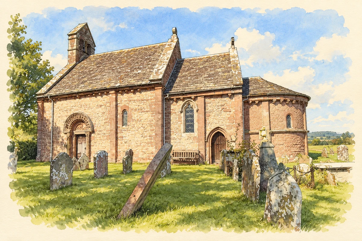
Watercolour and fine ink illustration of St Mary and St David’s Church, Kilpeck
Illustration · St Mary and St David’s Church, Kilpeck
History & heritage

Place & story

A settlement around a lord’s castle

Kilpeck’s castle stands close to the parish church, with the remains of a settlement beyond it. The earthworks still explain how these places fitted together: a ditched mound, an inner bailey between castle and village, and outer enclosures. This was a centre of authority within Archenfield, the border district also known as Ergyng, rather than an isolated church in open countryside. [3]

A church at Kilpeck appears in the Book of Llandaff, but the dating of the surviving building is debated. The manor belonged to William fitzNorman in 1086; his son Hugh is usually credited with the church’s construction. The secure documentary point is a grant of 1134, naming the church of St David and the castle chapel of St Mary in connection with a new dependency of St Peter’s Abbey, Gloucester. [4]

A compact building with an exuberant doorway

Historic England dates the sandstone church to about 1134–40. Its three parts decrease in width and height from nave to chancel to rounded apse. Around the exterior, carved human and animal heads support the roofline. The south doorway concentrates the decoration: serpents twist along the shafts, while beasts, fish and chevrons surround an entrance topped by a Tree of Life. [5]

The carvings need careful reading. The church’s own custodians stress that neither the founder’s intentions nor the masons’ thoughts can now be recovered with certainty. The richness of the images survives more securely than any single explanation of them; an interpretation should therefore be presented as an interpretation. [7]

Markets, visitors and declining lordship

King John stayed at the castle in 1211, 1212 and 1214. A Friday market and fairs were granted in the thirteenth century, with grants renewed in 1309. Religious patronage, the castle household and trading rights gave the settlement several overlapping functions; the church belonged to that wider concentration of activity. [4]

The castle later passed to the Butlers, Earls of Ormond, whose absence contributed to its deterioration. Leland found standing ruins in the 1530s. Its gardens and ponds formed part of a managed estate landscape, and the park continued to have value after the castle ceased to function as an occupied residence. The surviving banks and masonry belong to that long withdrawal as well as to its earlier power. [3]

Keeping the church in use

The church has undergone repeated repair. The parish account records an extensive campaign in 1898 under Roland Paul: the font was moved, drainage installed, roofs relaid and the interior replastered. Small traces of colour were found, although no complete painted scheme emerged. Later work included a lead covering over the south doorway in 1962–63 and exterior repointing in 2005–12. [6]

The Parochial Church Council describes the building as self-funded, dependent on the interest and contributions of visitors as well as its life as a place of worship. Its survival is consequently a continuing practical undertaking. The carved stone attracts attention, but maintenance of the fabric and churchyard sustains the place around it. [7]

Back to contents
Lives connected to this place

Notable people

Hugh de Kilpeck: a patron recorded through his gifts

Hugh de Kilpeck was the local lord usually credited with commissioning the church. His 1134 grant linked its church and castle chapel with Gloucester Abbey; the exact construction sequence remains debated. [4]

Roland Paul: recording and repairing

Roland Paul supervised the church repairs of 1898. The parish’s account links his work with a published report of the reopening and with a careful architectural drawing. He belongs to the later history of Kilpeck: the generations who documented and repaired the medieval building while adapting its interior for continued use. [6]

Back to contents
A chronology

Timeline

Kilpeck through time

  1. 1086 — William fitzNorman holds the manor of Kilpeck. [4]

  2. 1134 — A grant names the church and castle chapel in connection with the priory dependent on Gloucester Abbey. [4]

  3. About 1134–40 — Historic England’s date for the surviving church. [5]

  4. 1211, 1212 and 1214 — King John visits the castle. [4]

  5. 1309 — Market and fair grants are renewed. [4]

  6. 1898 — Roland Paul supervises a substantial repair campaign. [6]

  7. 2005–12 — The exterior is repointed with lime-based mortar. [6]

Back to contents

Population over time

A verified population series for Kilpeck as a settlement has not yet been added. Neighbourhood census figures are available below.

Neighbourhood census context

These figures describe statistical neighbourhoods, which may cover part of a place or include neighbouring places.

Neighbourhood census area · 1971–2021

Herefordshire 021

Population of the area containing the recorded point for Kilpeck, not the whole place. This area may cover part of the place or include neighbours.

05k10k15k20k1971: 9,478 people19711981: 8,741 people19811991: 9,146 people19912001: 10,259 people20012011: 10,962 people20112021: 10,857 people2021

Includes harmonised historical census estimates.

Sources: ONS · Paul Norman

View population figures
Herefordshire 021 — census population and harmonised historical estimates
Census yearPopulation
19719,478
19818,741
19919,146
200110,259
201110,962
202110,857
Sources and how to read this chart

Usual residents of the containing MSOA; this is local area context, not the population of the named settlement.. Boundary geography: 1 April 2022 (E02002925).

2011 and 2021 census counts harmonised by ONS to the same 1 April 2022 geography. Location matched to ONS 2021 MSOA polygons (full resolution, coastline clipped, V7). ONS exact-fit lookup marks this MSOA unchanged from 2011 (U); historical estimates use that same footprint.

1971–2011: Paul Norman harmonised historical estimates on 2011 MSOAs, rounded to whole residents (1971–1991 are modelled). 2021: ONS census count. The historical 2011 total can differ slightly from the ONS change-over-time 2011 total because of methodology and statistical disclosure controls. These are area estimates, not settlement totals.

Source: ONS Census change over time: usual resident population, 2011 and 2021. Open Government Licence v3.0. Retrieved 2026-10-26. Source: ONS MSOA December 2021 boundaries EW BFC V7. Open Government Licence v3.0. Retrieved 2026-10-26. Source: Paul Norman — Area characteristics: Great Britain 1971 to 2011. Creative Commons Attribution 4.0. Retrieved 2026-10-26. Source: ONS MSOA 2011 to MSOA 2021 exact-fit lookup for England and Wales. Open Government Licence v3.0. Retrieved 2026-10-26.

Recorded locationKilpeck51.96923° N · 2.80761° WInteractive map loads when this area enters view.
Approximate recorded location · Geographic source

Geographic context

Place type
Village
Country / region
England · West Midlands
County group
Herefordshire
Current administration
County of Herefordshire
Recorded coordinates
51.96923, -2.80761
OS Open Names ID
osgb4000000074579410

County groups are browsing aids. Current administrative and historic areas are recorded separately.

Recorded names

  • Kilpeck · en · official

Nearby heritage

Distances are from the recorded place point. Proximity does not establish that a site lies within the place boundary or belongs to its history.

Sources & further reading

  1. OS Open Names October 2026 · Source licence.
  2. Kilpeck Church · Visit Herefordshire
  3. Kilpeck Castle (HER 714) · Herefordshire Council, Herefordshire Through Time
  4. St Mary, Kilpeck, Herefordshire · Corpus of Romanesque Sculpture in Britain and Ireland
  5. Church of St Mary and St David, list entry 1099582 · Historic England
  6. Kilpeck Timeline · Kilpeck Parochial Church Council
  7. About · Kilpeck Parochial Church Council
  8. Illustration of St Mary and St David’s Church, Kilpeck, adapted from Kilpeck Church by AJD. CC BY-SA 2.0. AI-assisted watercolour and fine ink adaptation; simplified fine detail and removal of incidental clutter.

Geographic source retrieved 2026-10-26. History last researched 2026-10-27. How this page was prepared.