Village

Longtown

Longtown’s ridge-top street, castle earthworks and former school preserve the changing life of a Herefordshire border settlement: a planted borough that became a rural service centre.

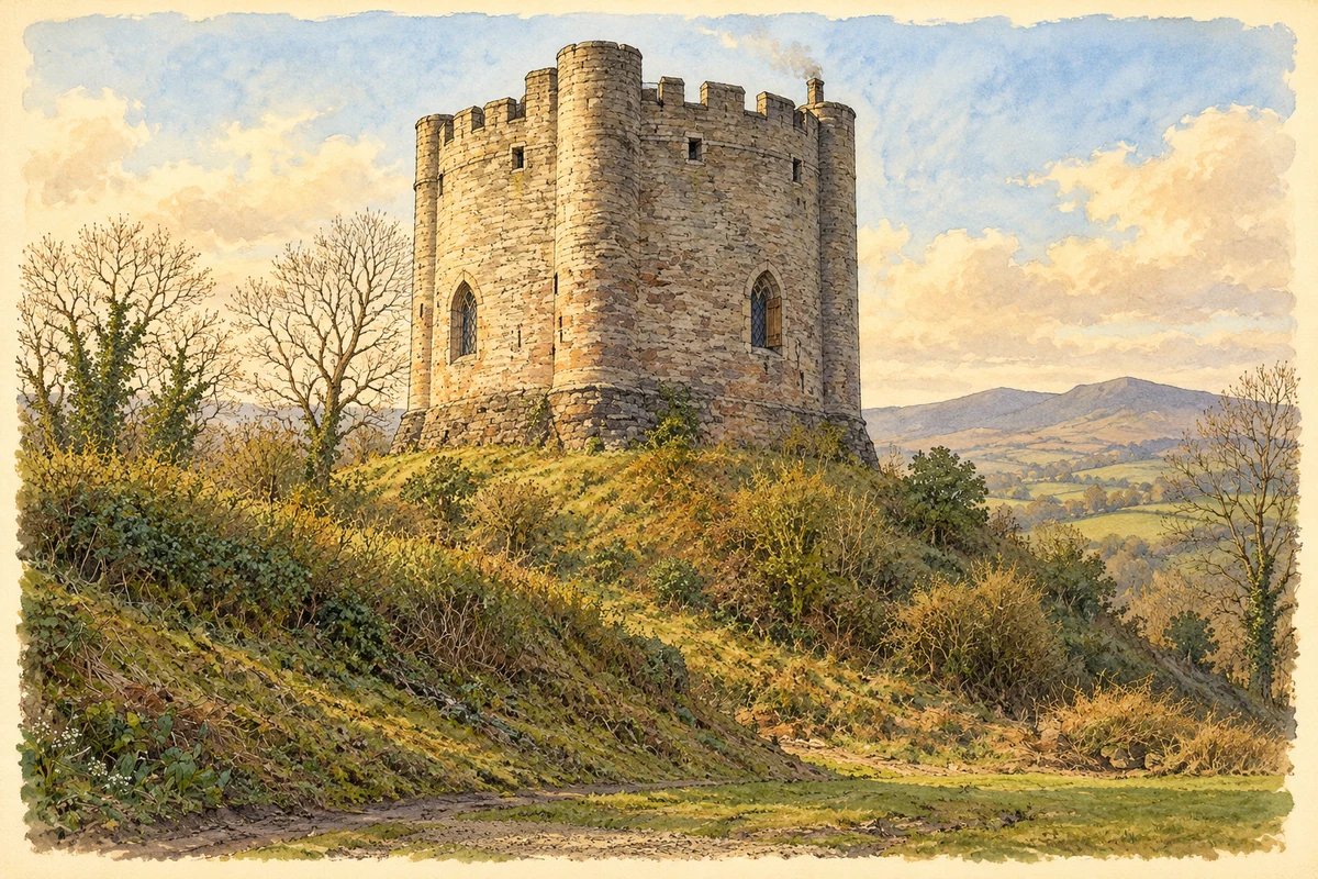
Watercolour historical reconstruction of Longtown Castle keep around 1350
Historical reconstruction · Longtown Castle keep, around 1350
Artistic reconstruction · Around 1350

Interpreted inhabited medieval keep; surviving cylinder, projecting turrets and motte retained.

Evidence and interpreted details

Uncertain details: Parapets, concealed roof and restored glazing are not a measured reconstruction. Date describes an imagined later-medieval use, not the debated original construction date.

Based on: Longtown Castle: official monument record; History of Longtown Castle: keep

History & heritage

Place & story

A settlement on the border ridge

Longtown stands in south-west Herefordshire close to the Welsh border, between the Black Mountains and farmland to the east. The castle and the borough planted beside it formed a connected enterprise: military control and settlement were developed together. Earthworks of the former town continue south along the road through the present village. [4]

The familiar castle occupies an older enclosure. English Heritage now identifies the surrounding rampart as Roman, with a Norman motte and timber tower inserted later. Documentary research and excavation suggest that the stone keep probably dates from the 1150s, earlier than the thirteenth-century date formerly assigned to it. The changing interpretation is part of the site’s history of investigation. [2]

Houses as well as defences

The scheduled monument includes parts of the medieval town as well as the castle. Platforms beside the road mark house plots with gardens behind; other earthworks represent agricultural enclosures. Such remains make the borough more than a name in a document. They preserve the arrangement of domestic space around the stronghold. [3]

Development has altered some areas, while open ground retains archaeological evidence. Historic England stresses the survival of the town plan and the known position of its weekly market. These traces shift attention from the keep to the people who occupied plots, cultivated ground and used a local trading centre. [3]

A borough loses its regional role

The de Lacys laid out a new borough to help finance their castle, extending settlement along the ridge. After the last Walter de Lacy died in 1241, his estate was divided between two granddaughters. Longtown’s regional importance diminished; the Black Death of 1348–49 further weakened the settlement. The castle nevertheless had a final garrison in 1403 during Owain Glyn Dwr’s rebellion. [2]

Schooling beside the ruins

A purpose-built school opened around 1869 near the castle, serving village children and the dispersed farms and cottages around it. Its teachers’ log books survive from 1873. They recorded attendance and routine progress, but also explained absences through weather, illness, markets and parental demands. These are the teachers’ accounts, written for their employers, rather than an unfiltered record of every household. [5]

An extension in 1895 added an entrance for infants and a house for the head teacher. The enlarged school remained in use until a replacement opened elsewhere in the village in 1979. Conversion of the old building into cottages in the 1980s gave the porches another purpose, while retaining a visible outline of the educational institution. [5]

A rural service centre in 1941

Kelly’s directory of 1941 describes a landscape predominantly in pasture, alongside wheat, barley and oats. It records fairs for livestock and bus services linking Longtown with Abergavenny, Hereford and Hay. Agriculture depended on connections beyond the village, while fairs brought business towards it. The directory offers a dated view of those connections, rather than a description of present-day services. [6]

Its commercial list includes a saddler and harness maker, a bootmaker, a blacksmith, shopkeepers and a motor engineer at Hillside garage, as well as many farmers and smallholders. Older rural crafts and motor transport appear together. The transcription’s warning that the list is incomplete prevents it from becoming a census of all local employment. [6]

Back to contents
Lives connected to this place

Notable people

Gilbert de Lacy: a probable builder

Gilbert recovered his father’s property around 1148 after the conflicts of King Stephen’s reign. English Heritage attributes the replacement of Longtown’s timber castle with stone probably to him. His connection is therefore a proposed building patronage supported by recent research, with the uncertainty retained. [2]

Back to contents
A chronology

Timeline

Longtown through time

  1. Probably the 1150s — The stone castle replaces the earlier timber structure. [2]

  2. 1403 — The castle is garrisoned during the Welsh rebellion. [2]

  3. Around 1869 — A new elementary school opens beside the castle. [5]

  4. 1895 — The school is extended and a head teacher’s house added. [5]

  5. 1979 — A replacement school opens on another village site. [5]

Back to contents

Population over time

A verified population series for Longtown as a settlement has not yet been added. Neighbourhood census figures are available below.

Neighbourhood census context

These figures describe statistical neighbourhoods, which may cover part of a place or include neighbouring places.

Neighbourhood census area · 1971–2021

Herefordshire 020

Population of the area containing the recorded point for Longtown, not the whole place. This area may cover part of the place or include neighbours.

01.8k3.5k5.3k7k1971: 4,630 people19711981: 5,059 people19811991: 5,253 people19912001: 5,811 people20012011: 6,067 people20112021: 6,060 people2021

Includes harmonised historical census estimates.

Sources: ONS · Paul Norman

View population figures
Herefordshire 020 — census population and harmonised historical estimates
Census yearPopulation
19714,630
19815,059
19915,253
20015,811
20116,067
20216,060
Sources and how to read this chart

Usual residents of the containing MSOA; this is local area context, not the population of the named settlement.. Boundary geography: 1 April 2022 (E02002924).

2011 and 2021 census counts harmonised by ONS to the same 1 April 2022 geography. Location matched to ONS 2021 MSOA polygons (full resolution, coastline clipped, V7). ONS exact-fit lookup marks this MSOA unchanged from 2011 (U); historical estimates use that same footprint.

1971–2011: Paul Norman harmonised historical estimates on 2011 MSOAs, rounded to whole residents (1971–1991 are modelled). 2021: ONS census count. The historical 2011 total can differ slightly from the ONS change-over-time 2011 total because of methodology and statistical disclosure controls. These are area estimates, not settlement totals.

Source: ONS Census change over time: usual resident population, 2011 and 2021. Open Government Licence v3.0. Retrieved 2026-10-26. Source: ONS MSOA December 2021 boundaries EW BFC V7. Open Government Licence v3.0. Retrieved 2026-10-26. Source: Paul Norman — Area characteristics: Great Britain 1971 to 2011. Creative Commons Attribution 4.0. Retrieved 2026-10-26. Source: ONS MSOA 2011 to MSOA 2021 exact-fit lookup for England and Wales. Open Government Licence v3.0. Retrieved 2026-10-26.

Recorded locationLongtown51.95489° N · 2.98740° WInteractive map loads when this area enters view.
Approximate recorded location · Geographic source

Geographic context

Place type
Village
Country / region
England · West Midlands
County group
Herefordshire
Current administration
County of Herefordshire
Recorded coordinates
51.95489, -2.98740
OS Open Names ID
osgb4000000074580002

County groups are browsing aids. Current administrative and historic areas are recorded separately.

Recorded names

  • Longtown · en · official

Nearby heritage

Distances are from the recorded place point. Proximity does not establish that a site lies within the place boundary or belongs to its history.

Sources & further reading

  1. OS Open Names October 2026 · Source licence.
  2. History of Longtown Castle · English Heritage
  3. Longtown castle and town,scheduled monument1021347 · Historic England
  4. Longtown,Herefordshire:a medieval castle and borough,AI/26/2003 · Nicky Smith / English Heritage
  5. Self portrait of a village school:Longtown school log books1873–1910 · Nina Wedell / Ewyas Lacy Study Group
  6. Kelly’s Directory of Herefordshire,1941:Longtown and Clodock · Kelly’s Directories / Ewyas Lacy Study Group transcript
  7. Illustration of Longtown Castle keep, adapted from Longtown Castle (Keep) by Fabian Musto. CC BY-SA 2.0. AI-assisted watercolour historical reconstruction from licensed present-day photograph; missing roofs, glazing and masonry interpreted.

Geographic source retrieved 2026-10-26. History last researched 2026-10-27. How this page was prepared.