Town

Ross-on-Wye

A bishop’s market town became a starting point for journeys through the Wye’s scenery. Its arcaded Market House, long property plots and public Prospect connect trade, local improvement and the growth of tourism.

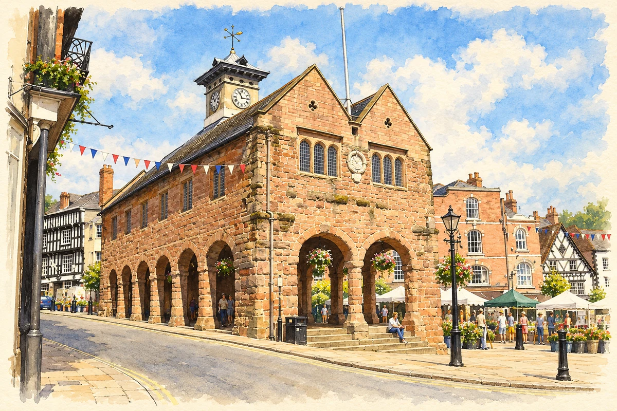
Watercolour and fine ink illustration of Ross-on-Wye Market House
Illustration · Ross-on-Wye Market House
History & heritage

Place & story

A market on the hill

Domesday Book records Ross as a manor and village belonging to the Bishop of Hereford, with a priest and mill. In 1138 King Stephen granted the right to weekly markets. These records establish a settlement with religious, agricultural and commercial functions before the river scenery became a reason to visit. [2]

The medieval town is still legible in its property pattern. Long burgage plots extend behind narrow street frontages around Broad Street, Market Place and High Street. The council’s conservation appraisal contrasts the red sandstone Market House with timber-framed buildings such as John Kyrle’s house opposite. Streets, plots and materials preserve different kinds of evidence about how the town grew. [3]

An open hall at the centre of exchange

The Market House gives the market a built focus. Historic England describes a seventeenth-century structure of local red sandstone, with an open ground-floor arcade beneath rooms above. Round arches rest on Doric columns, while a small clock lantern crowns the tiled roof. The building offered covered space without sealing traders off from the surrounding streets. [4]

Its survival has required continued care. The town council reported the completion of a conservation project in October 2024, supported by the National Lottery Heritage Fund and other funders and inspected during the work by Historic England. The council also planned for the Made in Ross art and craft gallery to return to the upper floor. Maintenance and ongoing activity both keep the old market building relevant. [9]

A church made over generations

St Mary’s is largely a thirteenth-century church. By the middle of the fourteenth century its east end had been extended, and a tower and porches had been added. The Markye Chapel followed in 1510; an organ chamber completed the present ground plan in the nineteenth century. This sequence explains why the church cannot be assigned to a single building date. [5]

Six surviving piscinae, the basins associated with altars, indicate that the medieval building once accommodated several altars. Later memorials to the Rudhall family and John Kyrle make the interior a record of local households and benefactors as well as worship. The church’s architectural changes and commemorative objects offer complementary ways into Ross’s history. [5]

Making a public prospect

John Kyrle leased the Prospect in 1696 and laid out gardens with a fountain and water supply; gates bearing his monogram and crest date from 1700. A riverside water engine installed by Kyrle and his partners in 1705–06 pumped water uphill to the fountain and reservoir. The view over the Wye was also a place of organised improvement, supported by practical engineering. [6]

The Prospect sits beside the church but opens the town towards its surrounding landscape. Kyrle’s work joined recreation, planting and a water supply in one public setting. It helps explain why the experience of Ross involves both tightly enclosed streets and an expansive view over the river below. [6] [3]

Visitors learn to look at the Wye

The Wye Tour developed from river excursions associated with Ross rector John Egerton, who had a boat built for taking guests downstream in 1745. Commercial boats later catered to growing demand. A journey between Ross and Chepstow offered visitors a sequence of views, stopping places and ruins, making the river a route to be experienced as scenery. [7]

William Gilpin’s journey in 1770 and the publication of his Observations on the River Wye in 1782 helped spread that fashion. The National Library of Wales connects his book with the rise of picturesque tourism: travellers learned to value scenery through ideas about composition and beauty. Its manuscript collections show later visitors following the same route, including Thomas Martyn’s recorded tour of 1801. [8]

The tour’s principal period of popularity ran from around 1760 into the 1830s. Commercial boats gave Ross another economic role alongside its market. The town’s importance lay partly in being a departure point: the landscapes that made the tour famous extended well beyond Ross itself. [7]

Back to contents
Lives connected to this place

Notable people

John Kyrle: the resident behind the name

John Kyrle was born at Dymock and inherited his house opposite Ross’s Market House after his father’s death in the 1650s. He supported schools, helped poor and sick neighbours and became associated with practical improvements to the town. Alexander Pope’s Moral Essays celebrated him as the Man of Ross. His local importance rests on residence and charitable work, rather than birth in the town. [6]

William Gilpin: a visitor with influence

William Gilpin’s connection with Ross was as a traveller and writer. His river tour began here in 1770; the book followed twelve years later. He helped give readers a way to judge landscapes through picturesque beauty. The distinction matters: Ross was the starting point of an influential journey, while his account concerned a much wider stretch of the Wye and South Wales. [8] [7]

Back to contents
A chronology

Timeline

Ross-on-Wye through time

  1. 1086 — Domesday Book records the bishop’s manor, priest and mill at Ross. [2]

  2. 1138 — King Stephen grants weekly market rights. [2]

  3. Thirteenth–fourteenth centuries — Major phases of St Mary’s Church are built. [5]

  4. Seventeenth century — The sandstone Market House takes its surviving form. [4]

  5. 1696 / 1705–06 — Kyrle leases the Prospect; a later water engine pumps river water uphill. [6]

  6. 1745 — John Egerton commissions a boat for excursions down the Wye. [7]

  7. 1770 / 1782 — Gilpin makes his river tour and subsequently publishes his account. [8]

  8. October 2024 — Conservation work on the Market House is completed. [9]

Back to contents

Population over time

Built-up area · Settlement · Census 2021

Ross-on-Wye

10,990people · 2021

Census 2021 population of the named settlement, using ONS built-up area boundaries.

Published census counts.

Sources: ONS: Towns and cities, characteristics of built-up areas, Census 2021 (Table 1c)

View population figures
Ross-on-Wye — census population
Census yearPopulation
202110,990
Sources and how to read this chart

Usual residents on 21 March 2021; published ONS count rounded to the nearest 5.. Boundary geography: December 2022 (E63004125).

Census 2021 population of the named settlement, using ONS built-up area boundaries.

ONS Table 1c rounds counts to the nearest 5 and suppresses counts below 10. Matched by exact settlement name or individually reviewed district-qualified name, with its coordinate strictly inside that same official BUA boundary. The 2022 BUA geography changed methodology and cannot be directly compared with 2011 BUAs. Contains OS data © Crown copyright and database right 2026. Contains National Statistics data © Crown copyright and database right 2026.

Source: ONS: Towns and cities, characteristics of built-up areas, Census 2021 (Table 1c). Open Government Licence v3.0. Retrieved 2026-10-26. Source: ONS and Ordnance Survey: Built Up Areas December 2022 GB BGG. Open Government Licence v3.0. Retrieved 2026-10-26.

Neighbourhood census context

These figures describe statistical neighbourhoods, which may cover part of a place or include neighbouring places.

Neighbourhood census area · 1971–2021

Herefordshire 022

Population of the area containing the recorded point for Ross-on-Wye, not the whole place. This area may cover part of the place or include neighbours.

05k10k15k20k1971: 6,612 people19711981: 8,378 people19811991: 9,695 people19912001: 10,130 people20012011: 10,573 people20112021: 10,990 people2021

Includes harmonised historical census estimates.

Sources: ONS · Paul Norman

View population figures
Herefordshire 022 — census population and harmonised historical estimates
Census yearPopulation
19716,612
19818,378
19919,695
200110,130
201110,573
202110,990
Sources and how to read this chart

Usual residents of the containing MSOA; this is local area context, not the population of the named settlement.. Boundary geography: 1 April 2022 (E02002926).

2011 and 2021 census counts harmonised by ONS to the same 1 April 2022 geography. Location matched to ONS 2021 MSOA polygons (full resolution, coastline clipped, V7). ONS exact-fit lookup marks this MSOA unchanged from 2011 (U); historical estimates use that same footprint.

1971–2011: Paul Norman harmonised historical estimates on 2011 MSOAs, rounded to whole residents (1971–1991 are modelled). 2021: ONS census count. The historical 2011 total can differ slightly from the ONS change-over-time 2011 total because of methodology and statistical disclosure controls. These are area estimates, not settlement totals.

Source: ONS Census change over time: usual resident population, 2011 and 2021. Open Government Licence v3.0. Retrieved 2026-10-26. Source: ONS MSOA December 2021 boundaries EW BFC V7. Open Government Licence v3.0. Retrieved 2026-10-26. Source: Paul Norman — Area characteristics: Great Britain 1971 to 2011. Creative Commons Attribution 4.0. Retrieved 2026-10-26. Source: ONS MSOA 2011 to MSOA 2021 exact-fit lookup for England and Wales. Open Government Licence v3.0. Retrieved 2026-10-26.

Recorded locationRoss-on-Wye51.91394° N · 2.58369° WInteractive map loads when this area enters view.
Approximate recorded location · Geographic source

Geographic context

Place type
Town
Country / region
England · West Midlands
County group
Herefordshire
Current administration
County of Herefordshire
Recorded coordinates
51.91394, -2.58369
OS Open Names ID
osgb4000000074579457

County groups are browsing aids. Current administrative and historic areas are recorded separately.

Recorded names

  • Ross-on-Wye · en · official

Nearby heritage

Distances are from the recorded place point. Proximity does not establish that a site lies within the place boundary or belongs to its history.

Sources & further reading

  1. OS Open Names October 2026 · Source licence.
  2. History of Ross-on-Wye · Ross-on-Wye Town Council
  3. Ross-on-Wye Conservation Area Appraisal (draft,September2006) · Herefordshire Council
  4. Market House: list entry1098680 · Historic England
  5. St Mary’s Church: History · The Ross Parishes
  6. John Kyrle Circular Walk · Herefordshire Council
  7. Inspirational Valley: the Wye Tour (2019) · Wye Valley National Landscape Partnership
  8. Early Tourists · National Library of Wales
  9. Town Council Newsletter, October2024 · Ross-on-Wye Town Council
  10. Illustration of Ross-on-Wye Market House, adapted from Market House, Ross on Wye - geograph.org.uk - 4604580.jpg by John Winder. CC BY-SA 2.0. AI-assisted watercolour and fine ink adaptation; incidental clutter simplified, warm cream paper margins. Architectural forms follow the inspected reference.

Geographic source retrieved 2026-10-26. History last researched 2026-10-26. How this page was prepared.