Village

Wigmore

Wigmore’s ruined stronghold belonged to a landscape of farms, food supplies and religious foundations. Below it, church fittings and a former cobbler’s shop preserve other scales of village life.

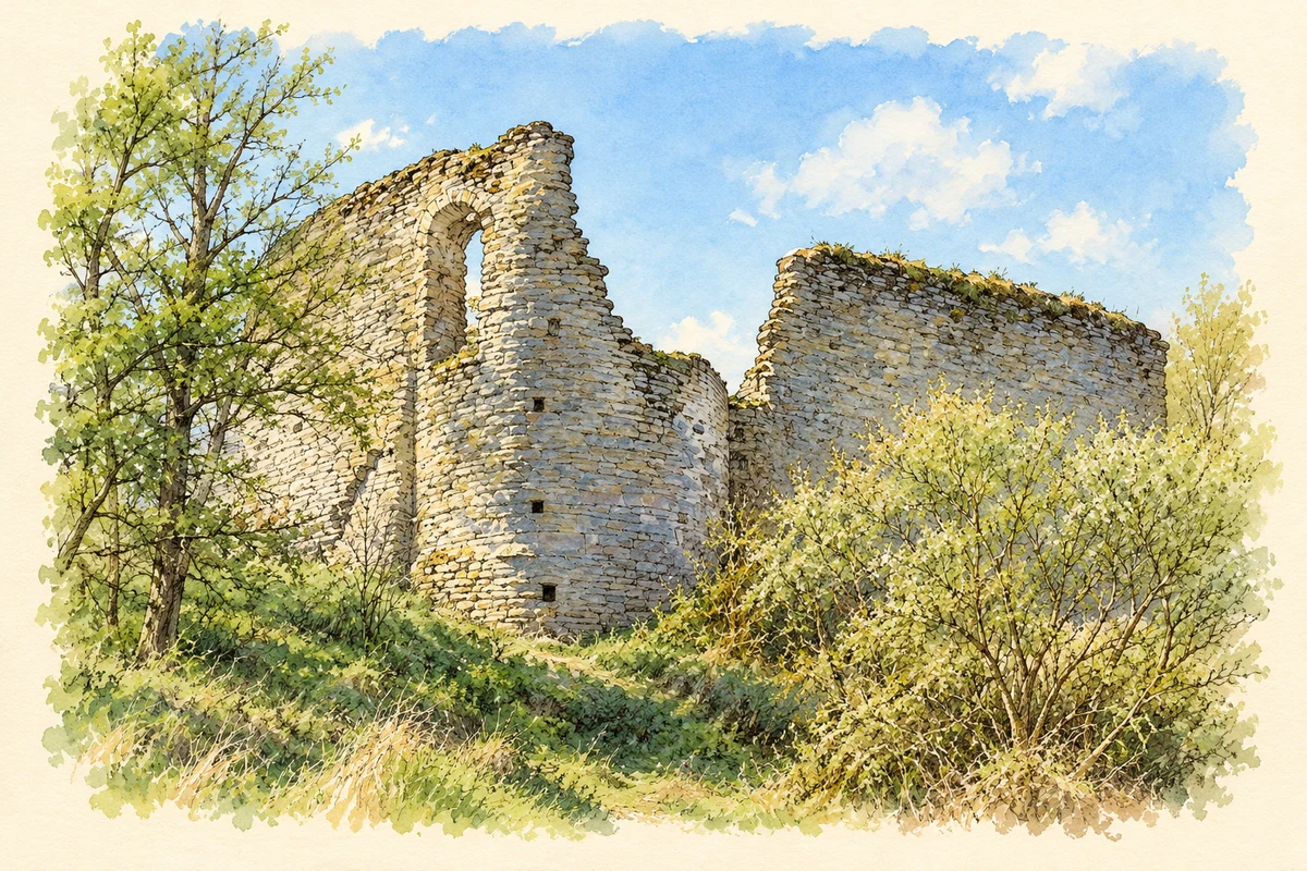
Watercolour and fine ink illustration of Wigmore Castle
Illustration · Wigmore Castle
History & heritage

Place & story

A Marcher seat of power

William fitz Osbern founded Wigmore Castle in 1067, using timber defences on substantial earthworks. The Mortimers later rebuilt in stone and made it a base for controlling lands in central Wales. Their authority as Marcher lords included courts, revenues and the power to wage war. [2]

Wigmore was also a settlement around that authority. Herefordshire Council’s account of the medieval county identifies it as a borough in the Domesday survey. Castles supplied administration and protection, attracting settlement around them; Wigmore’s early urban status places the surviving village within that wider pattern of border development. [4]

Feeding and housing the castle

The castle occupies a narrow ridge above low-lying Wigmore Moor and the road across it. Its outer bailey contained stables, granaries and stores. Beyond the walls lay deer parks, fishponds, a dovecot and a rabbit warren, while the flatter valley land was farmed. Defence depended on a much wider productive landscape. [3]

The inner bailey was the principal residential area, protected by a gatehouse, ditch and curtain wall. Spacious towers and the remaining corner of a great hall reveal accommodation as well as fortification. About a mile north stood Wigmore Abbey, the Mortimers’ burial place: family memory and religious patronage extended beyond the castle itself. [3]

St James: a building repeatedly remade

St James’s Church has a late eleventh-century core, with rebuilding in the fourteenth century, later medieval changes and restoration by G. Bodley in 1864. Its sandstone masonry and west tower stand for a long sequence of investment. The church’s history continued after the castle ceased to function as a residence. [5]

Inside, medieval furnishings survive among later additions: an octagonal font, fifteenth-century choir stalls and a sixteenth-century timber pulpit with linenfold panels. A medieval altar slab was reused as a window sill in the tower. These objects show both continuity and the changing treatment of older religious fabric. [5]

From 1 August 2026, St James closed to public worship and Wigmore village moved into the Mortimer Cross Benefice, according to the parish notice. [7]

Work on Castle Street

The former cobbler’s shop and adjoining dwellings on Castle Street bring the story down to the level of work and housing. Historic England dates the timber-framed building to the seventeenth century, with nineteenth- and twentieth-century alterations. Originally a shop and two dwellings, it was later combined as one house. [6]

Its painted brick and rendered infill, raised roof and later brick base record adaptation rather than an untouched survival. The building’s former uses connect a trade serving local households with the domestic accommodation beside it, close to both church and castle. [6]

Conserving a living ruin

The Harleys appear to have dismantled parts of Wigmore during the Civil War to prevent Royalist occupation. Centuries of neglect followed. In the 1990s English Heritage retained vegetation and accumulated debris while consolidating walls; grasses and flowers formed protective soft capping. Conservation preserved habitats as well as medieval masonry. [2]

Back to contents
Lives connected to this place

Notable people

Roger Mortimer: a lord entertaining a king

Roger Mortimer, first Earl of March, added residential towers and a gatehouse porch in the early fourteenth century. In 1329 he hosted Edward III and Queen Isabella at a tournament at Wigmore. His fall and execution in 1330 make the castle a setting for national political power as well as local lordship. [2]

Back to contents
A chronology

Timeline

Wigmore through time

  1. 1067 — William fitz Osbern founds the castle. [2]

  2. 1086 — Wigmore appears as a borough in the Domesday survey. [4]

  3. 1329 — Roger Mortimer hosts a royal tournament at Wigmore. [2]

  4. Seventeenth century — The Castle Street building later known as the cobbler’s shop is constructed. [6]

  5. 1864 — G. Bodley restores St James’s Church. [5]

  6. 1990s — English Heritage conserves the castle while retaining its natural environment. [2]

  7. 1 August 2026 — St James closes to public worship, according to the parish notice. [7]

Back to contents

Population over time

Built-up area · Settlement · Census 2021

Wigmore

530people · 2021

Census 2021 population of the named settlement, using ONS built-up area boundaries.

Published census counts.

Sources: ONS: Towns and cities, characteristics of built-up areas, Census 2021 (Table 1c)

View population figures
Wigmore — census population
Census yearPopulation
2021530
Sources and how to read this chart

Usual residents on 21 March 2021; published ONS count rounded to the nearest 5.. Boundary geography: December 2022 (E63003219).

Census 2021 population of the named settlement, using ONS built-up area boundaries.

ONS Table 1c rounds counts to the nearest 5 and suppresses counts below 10. Matched by exact settlement name or individually reviewed district-qualified name, with its coordinate strictly inside that same official BUA boundary. The 2022 BUA geography changed methodology and cannot be directly compared with 2011 BUAs. Contains OS data © Crown copyright and database right 2026. Contains National Statistics data © Crown copyright and database right 2026.

Source: ONS: Towns and cities, characteristics of built-up areas, Census 2021 (Table 1c). Open Government Licence v3.0. Retrieved 2026-10-26. Source: ONS and Ordnance Survey: Built Up Areas December 2022 GB BGG. Open Government Licence v3.0. Retrieved 2026-10-26.

Neighbourhood census context

These figures describe statistical neighbourhoods, which may cover part of a place or include neighbouring places.

Neighbourhood census area · 1971–2021

Herefordshire 001

Population of the area containing the recorded point for Wigmore, not the whole place. This area may cover part of the place or include neighbours.

01.8k3.5k5.3k7k1971: 4,996 people19711981: 4,970 people19811991: 5,372 people19912001: 6,043 people20012011: 6,046 people20112021: 6,263 people2021

Includes harmonised historical census estimates.

Sources: ONS · Paul Norman

View population figures
Herefordshire 001 — census population and harmonised historical estimates
Census yearPopulation
19714,996
19814,970
19915,372
20016,043
20116,046
20216,263
Sources and how to read this chart

Usual residents of the containing MSOA; this is local area context, not the population of the named settlement.. Boundary geography: 1 April 2022 (E02002905).

2011 and 2021 census counts harmonised by ONS to the same 1 April 2022 geography. Location matched to ONS 2021 MSOA polygons (full resolution, coastline clipped, V7). ONS exact-fit lookup marks this MSOA unchanged from 2011 (U); historical estimates use that same footprint.

1971–2011: Paul Norman harmonised historical estimates on 2011 MSOAs, rounded to whole residents (1971–1991 are modelled). 2021: ONS census count. The historical 2011 total can differ slightly from the ONS change-over-time 2011 total because of methodology and statistical disclosure controls. These are area estimates, not settlement totals.

Source: ONS Census change over time: usual resident population, 2011 and 2021. Open Government Licence v3.0. Retrieved 2026-10-26. Source: ONS MSOA December 2021 boundaries EW BFC V7. Open Government Licence v3.0. Retrieved 2026-10-26. Source: Paul Norman — Area characteristics: Great Britain 1971 to 2011. Creative Commons Attribution 4.0. Retrieved 2026-10-26. Source: ONS MSOA 2011 to MSOA 2021 exact-fit lookup for England and Wales. Open Government Licence v3.0. Retrieved 2026-10-26.

Recorded locationWigmore52.31511° N · 2.85441° WInteractive map loads when this area enters view.
Approximate recorded location · Geographic source

Geographic context

Place type
Village
Country / region
England · West Midlands
County group
Herefordshire
Current administration
County of Herefordshire
Recorded coordinates
52.31511, -2.85441
OS Open Names ID
osgb4000000074560992

County groups are browsing aids. Current administrative and historic areas are recorded separately.

Recorded names

  • Wigmore · en · official

Nearby heritage

Distances are from the recorded place point. Proximity does not establish that a site lies within the place boundary or belongs to its history.

Sources & further reading

  1. OS Open Names October 2026 · Source licence.
  2. History of Wigmore Castle · English Heritage
  3. Description of Wigmore Castle · English Heritage
  4. The medieval period · Herefordshire Council
  5. Church of St James: list entry 1178822 · Historic England
  6. Old Cobblers Shop and adjoining dwellings: list entry 1349894 · Historic England
  7. Parish of Wigmore Abbey · Parish of Wigmore Abbey
  8. Illustration of Wigmore Castle, adapted from Ruins of Wigmore Castle by PAUL FARMER. CC BY-SA 2.0. AI-assisted watercolour and fine ink adaptation; simplified fine detail and removal of incidental clutter.

Geographic source retrieved 2026-10-26. History last researched 2026-10-27. How this page was prepared.