Town

Whitchurch

Roman footwear, market transport and public clocks reveal successive kinds of work in this Shropshire town. Its history connects a strategic route with households, farms and skilled manufacturers.

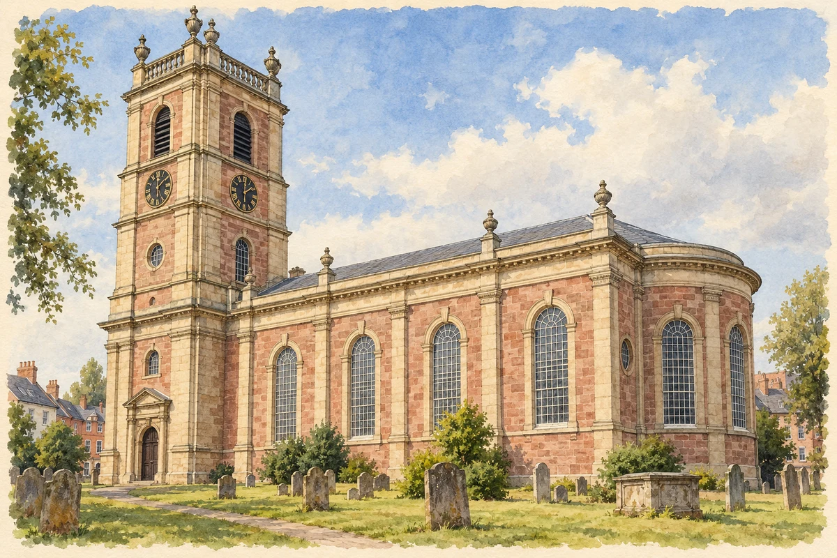
Watercolour and fine ink illustration of St Alkmund’s Church, Whitchurch
Illustration · St Alkmund’s Church, Whitchurch
Original illustration; researched sources
Research sources

Original architectural composition based on the cited building descriptions; incidental setting and fine details are interpretive.

National Churches Trust: St Alkmund; Whitchurch Heritage Centre: St Alkmund

History & heritage

Place & story

A fort becomes a town

The Roman army established a fort here before AD 70, between Wroxeter and Chester. After about forty years it was abandoned and levelled, and civilian settlement took its place. Mediolanum expanded south along the road, acquired earthen defences around AD 170 and later received a stone wall. It survived into at least the fourth century. [2]

A modern infrastructure repair brought ordinary Roman lives back into view. Replacement of a collapsed culvert carrying Staggs Brook in 2016 uncovered wet deposits containing a wooden trackway, structural timbers, pottery and fifteen leather shoes. Adult and children’s footwear survived, some complete and decorated, because the silts protected organic materials. [2]

Markets and movement

By the thirteenth century Whitchurch had a weekly market and annual fair serving farming communities. Later it became an overnight coaching stop between London and Ireland. A branch canal and wharf in the early nineteenth century reduced the cost of moving heavy goods and widened the market for local produce. [3]

The Crewe–Shrewsbury railway reached Whitchurch in 1858 with a goods shed and cattle dock. A further line opened towards Ellesmere and Oswestry in 1863. Transport supported both agricultural trade and industry; the Heritage Centre links improved connections with the development of William Smith’s iron foundry. [3]

Purpose-built cattle-market premises opened in 1878, removing animals from the streets. The cheese fair established in 1899 met every three weeks. These facilities connected the town’s commercial life with its dairying hinterland: Whitchurch traded Cheshire cheese across a county boundary rather than producing a purely urban economy. [3]

A church holding earlier lives

St Alkmund’s preserves objects from more than one building phase. Medieval glass survives in the north aisle, while the sandstone font is dated 1661. An eighteenth-century pulpit’s sounding board became a hexagonal table. The surviving furnishings therefore tell a longer story than the present church’s exterior alone. [5]

Two John Talbots must be distinguished. On the south side is the tomb and armoured effigy of the fifteenth-century commander; on the north is a later namesake associated with founding the grammar school. The tower’s Joyce clock mechanism provides another connection between a place of worship and the town’s working history. [5]

Making time for public places

The Joyce family business began at Cockshutt, elsewhere in north Shropshire, before moving to Whitchurch High Street in the 1780s. Longcase clocks preceded the large turret clocks developed in the 1830s. The shift took the firm’s work from domestic interiors into churches, stations and other public buildings. [4]

The Heritage Centre displays the firm’s history and identifies surviving station clocks at Carnforth and Liverpool Lime Street. These products linked Whitchurch craftsmanship with the shared schedules of travellers elsewhere. The town’s railway story includes the clocks marking time as well as the movement of passengers, cattle and goods. [4]

Back to contents
Lives connected to this place

Notable people

Thomas Joyce: clocks for institutions

Thomas Joyce began making large clocks for churches and public buildings in 1834. His local connection is to the Whitchurch family firm, whose earlier origins lay at Cockshutt. Church commissions around the region demonstrate how a specialised town workshop supplied institutions well beyond its immediate streets. [4]

Edward German: a composer born at an inn

Edward German was born German Edward Jones at Whitchurch’s Vaults Inn on 17 February 1862. He reordered his names while studying at the Royal Academy of Music and later dropped Jones. His career brought operetta and orchestral music to a national audience, including Merrie England in 1902 and Tom Jones in 1907. [6]

German’s connection with his birthplace continued through remembrance. The Heritage Centre holds photographs, examples of his work and parts of his dress uniform. A Whitchurch music festival in 2009 celebrated his life, making his compositions part of the town’s cultural activity long after his death in London in 1936. [6]

Back to contents
A chronology

Timeline

Whitchurch through time

  1. Before AD 70 — A Roman fort is established between Wroxeter and Chester. [2]

  2. 1780s — The Joyce clockmaking business moves from Cockshutt to Whitchurch. [4]

  3. 1834 — Thomas Joyce starts making large public clocks. [4]

  4. 1858 — The Crewe–Shrewsbury railway reaches the town. [3]

  5. 1862 — Edward German is born at the Vaults Inn. [6]

  6. 1878 — Purpose-built cattle-market premises open. [3]

  7. 2016 — Culvert replacement uncovers waterlogged Roman objects beside Staggs Brook. [2]

Back to contents

Population over time

Built-up area · Settlement · Census 2021

Whitchurch (Shropshire)

9,855people · 2021

Census 2021 population of the named settlement, using ONS built-up area boundaries.

Published census counts.

Sources: ONS: Towns and cities, characteristics of built-up areas, Census 2021 (Table 1c)

View population figures
Whitchurch (Shropshire) — census population
Census yearPopulation
20219,855
Sources and how to read this chart

Usual residents on 21 March 2021; published ONS count rounded to the nearest 5.. Boundary geography: December 2022 (E63001986).

Census 2021 population of the named settlement, using ONS built-up area boundaries.

ONS Table 1c rounds counts to the nearest 5 and suppresses counts below 10. Matched by exact settlement name or individually reviewed district-qualified name, with its coordinate strictly inside that same official BUA boundary. The 2022 BUA geography changed methodology and cannot be directly compared with 2011 BUAs. Contains OS data © Crown copyright and database right 2026. Contains National Statistics data © Crown copyright and database right 2026.

Source: ONS: Towns and cities, characteristics of built-up areas, Census 2021 (Table 1c). Open Government Licence v3.0. Retrieved 2026-10-26. Source: ONS and Ordnance Survey: Built Up Areas December 2022 GB BGG. Open Government Licence v3.0. Retrieved 2026-10-26.

Neighbourhood census context

These figures describe statistical neighbourhoods, which may cover part of a place or include neighbouring places.

Neighbourhood census area · 1971–2021

Shropshire 001

Population of the area containing the recorded point for Whitchurch, not the whole place. This area may cover part of the place or include neighbours.

05k10k15k20k1971: 6,658 people19711981: 7,611 people19811991: 8,043 people19912001: 8,829 people20012011: 9,884 people20112021: 10,142 people2021

Includes harmonised historical census estimates.

Sources: ONS · Paul Norman

View population figures
Shropshire 001 — census population and harmonised historical estimates
Census yearPopulation
19716,658
19817,611
19918,043
20018,829
20119,884
202110,142
Sources and how to read this chart

Usual residents of the containing MSOA; this is local area context, not the population of the named settlement.. Boundary geography: 1 April 2022 (E02006015).

2011 and 2021 census counts harmonised by ONS to the same 1 April 2022 geography. Location matched to ONS 2021 MSOA polygons (full resolution, coastline clipped, V7). ONS exact-fit lookup marks this MSOA unchanged from 2011 (U); historical estimates use that same footprint.

1971–2011: Paul Norman harmonised historical estimates on 2011 MSOAs, rounded to whole residents (1971–1991 are modelled). 2021: ONS census count. The historical 2011 total can differ slightly from the ONS change-over-time 2011 total because of methodology and statistical disclosure controls. These are area estimates, not settlement totals.

Source: ONS Census change over time: usual resident population, 2011 and 2021. Open Government Licence v3.0. Retrieved 2026-10-26. Source: ONS MSOA December 2021 boundaries EW BFC V7. Open Government Licence v3.0. Retrieved 2026-10-26. Source: Paul Norman — Area characteristics: Great Britain 1971 to 2011. Creative Commons Attribution 4.0. Retrieved 2026-10-26. Source: ONS MSOA 2011 to MSOA 2021 exact-fit lookup for England and Wales. Open Government Licence v3.0. Retrieved 2026-10-26.

Recorded locationWhitchurch52.96955° N · 2.68417° WInteractive map loads when this area enters view.
Approximate recorded location · Geographic source

Geographic context

Place type
Town
Country / region
England · West Midlands
County group
Shropshire
Current administration
Shropshire
Recorded coordinates
52.96955, -2.68417
OS Open Names ID
osgb4000000074561875

County groups are browsing aids. Current administrative and historic areas are recorded separately.

Recorded names

  • Whitchurch · en · official

Nearby heritage

Distances are from the recorded place point. Proximity does not establish that a site lies within the place boundary or belongs to its history.

Sources & further reading

  1. OS Open Names October 2026 · Source licence.
  2. Archaeological remains discovered that shed new light on Roman Whitchurch · Shropshire Council
  3. Whitchurch History and Heritage · Whitchurch Museum & Archives
  4. Clock making · Whitchurch Museum & Archives
  5. St Alkmund’s Church · Whitchurch Museum & Archives
  6. Sir Edward German · Whitchurch Museum & Archives
  7. Original illustration of St Alkmund’s Church, Whitchurch by PlaceHistory. Researched sources are linked beneath the illustration. Original composition from inspected architectural facts; no source photograph copied or used as an image-edit input. Fine detail is interpretive, not a measured survey.

Geographic source retrieved 2026-10-26. History last researched 2026-10-27. How this page was prepared.