Town

Cannock

A medieval market and a fashionable spa preceded Cannock’s industrial expansion. Coal, edge tools and transport changed the town and its neighbouring communities; postwar rebuilding changed its centre again.

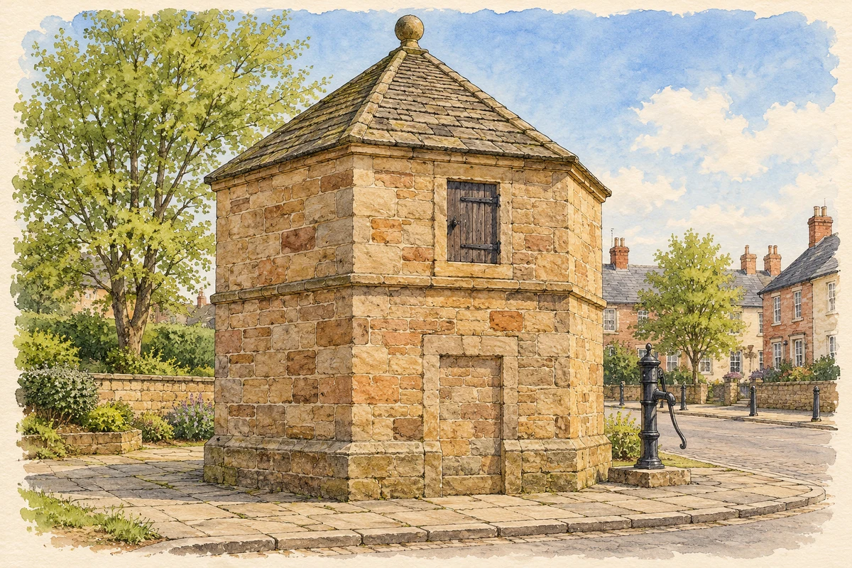
Watercolour and fine ink illustration of The Conduit Head, High Green, Cannock
Illustration · The Conduit Head, High Green, Cannock
Original illustration; researched sources
Research sources

Original architectural composition based on the cited building descriptions; incidental setting and fine details are interpretive.

Historic England: Cannock Conduit Head; Staffordshire Past Track: High Green Conduit

History & heritage

Place & story

A market in the hunting forest

Cannock appears in Domesday Book, within the landscape that became a royal hunting ground in 1086. In 1189 its manor passed to the Bishop of Coventry and Lichfield. The bishop’s lordship forms the setting for the later market town, before the much larger settlement created by industrial employment. [2]

A grant in 1259 authorised a weekly market. Roads converging on Cannock connected it with Lichfield, Stafford and Walsall, while Watling Street ran about a mile away. The market and road network provided a basis for trade long before coal could be carried to distant customers by canal and railway. [2]

St Luke’s: an older centre of community life

St Luke’s church preserves a physical history older than the spa houses and mining expansion. Historic England identifies twelfth-century origins in fabric surviving in the north aisle. Its nave arcades and tower were enlarged in the fourteenth century, with further work in the fifteenth. Local sandstone gives the building its characteristic material. [3]

Between 1878 and 1882 Stafford architect Nicholas Joyce lengthened the nave and aisles by two bays, built a new chancel and added a vestry. The surviving church therefore combines medieval fabric with Victorian enlargement, rather than belonging to a single construction date. Historic England singles out the quality and extent of its medieval work when explaining its Grade II* listing. [3]

Twentieth-century additions made room for remembrance as well as worship. A war-memorial chapel was built in 1949, and south-aisle memorial windows include one depicting soldiers receiving Communion. A new porch followed in 1957. These changes show continuing investment in an inherited building while the town around it underwent redevelopment. [3]

Water and wealthy households

During the seventeenth and eighteenth centuries Cannock acquired a reputation as a spa because of its water. Affluent families were attracted to the town, and the houses around High Green preserve evidence of their presence. High Green was then the town centre, giving the spa episode a particular location in the surviving streets. [2]

Road travel also brought passing business. By 1818 coaches on the London–Liverpool route called three times a week. In 1851 White’s directory could still describe Cannock as a substantial, well-built village: its later industrial scale should not be projected back onto this earlier period. [2]

Coal and a wider manufacturing district

Coal industry expansion after the middle of the nineteenth century drew miners and their families into the area. New housing and services followed. Canal and railway connections carried coal from Cannock and the surrounding district across the country, linking changes in the town’s streets with an economy extending far beyond them. [2]

Coal was one part of a varied industrial district. Brickmaking, tilemaking, iron founding and the manufacture of cutting tools also mattered. Wedges Mills, Churchbridge and Bridgtown developed south of Cannock with housing for edge-tool workers; the council’s heritage trail identifies Gilpin and Whitehouse as major employers. These neighbouring communities belong to the wider story without being interchangeable with the town centre. [2]

District government and a rebuilt centre

Cannock Urban District was established in 1894, following division into the wards of Cannock, Chadsmoor and Hednesford in 1877. Bridgtown, Heath Hayes and Littleworth were added as wards in 1900. Later boundary changes brought in further places, and Cannock Chase District was formed in 1974. These administrative areas describe a changing group of settlements, rather than a fixed town boundary. [2]

Redevelopment in the 1950s and 1960s changed the south-western parts of town and removed familiar central buildings. The market hall, built in 1869, and the Crown Hotel were demolished in the early 1960s for modern shops. A shopping centre completed in 1996 and development at High Green Court beginning in 2002 continued the alteration of Cannock’s commercial centre. [2]

The council’s account of Woolworth’s offers a smaller-scale view of changing shopping habits. Its Market Place branch opened in 1935 with goods priced at threepence or sixpence and assistants serving customers at counters. In 1972 it adopted self-service, a change in everyday retail practice alongside the more visible rebuilding outside. [2]

Back to contents
Lives connected to this place

Notable people

Glenn Hughes: from Cannock to international rock

Singer, bass guitarist and songwriter Glenn Hughes is identified as a Cannock native by his official biography. His early influences combined British rock with American soul and rhythm and blues. Trapeze gave him his first substantial success, with early-1970s recordings that brought those influences together. His connection with Cannock is his origin, rather than a claim that all his later music was made in the town. [4]

Hughes joined Deep Purple in 1973 alongside singer David Coverdale, following the departures of Ian Gillan and Roger Glover. He appeared on Burn, released in 1974, and two further studio albums before that line-up ended in 1976. A solo album followed in 1977. The trajectory adds a musical life to a town history often dominated by coal and manufacturing. [4]

Back to contents
A chronology

Timeline

Milestones

  1. 1086: Cannock is recorded in Domesday Book, within the royal hunting landscape. [2]

  2. 1189: The manor passes to the Bishop of Coventry and Lichfield. [2]

  3. 1259: A weekly market is authorised. [2]

  4. Seventeenth–eighteenth centuries: Cannock gains a reputation as a spa. [2]

  5. 1878–82: Nicholas Joyce enlarges St Luke’s church. [3]

  6. 1894: Cannock Urban District is formed. [2]

  7. 1949: A war-memorial chapel is added to St Luke’s. [3]

  8. Early 1960s: The market hall and Crown Hotel are demolished. [2]

  9. 1973: Cannock native Glenn Hughes joins Deep Purple. [4]

  10. 1974: Cannock Chase District is formed. [2]

  11. 1996: The new shopping centre is completed. [2]

Back to contents

Population over time

Built-up area · Settlement · Census 2021

Cannock

63,065people · 2021

Census 2021 population of the named settlement, using ONS built-up area boundaries.

Published census counts.

Sources: ONS: Towns and cities, characteristics of built-up areas, Census 2021 (Table 1c)

View population figures
Cannock — census population
Census yearPopulation
202163,065
Sources and how to read this chart

Usual residents on 21 March 2021; published ONS count rounded to the nearest 5.. Boundary geography: December 2022 (E63002477).

Census 2021 population of the named settlement, using ONS built-up area boundaries.

ONS Table 1c rounds counts to the nearest 5 and suppresses counts below 10. Matched by exact settlement name or individually reviewed district-qualified name, with its coordinate strictly inside that same official BUA boundary. The 2022 BUA geography changed methodology and cannot be directly compared with 2011 BUAs. Contains OS data © Crown copyright and database right 2026. Contains National Statistics data © Crown copyright and database right 2026.

Source: ONS: Towns and cities, characteristics of built-up areas, Census 2021 (Table 1c). Open Government Licence v3.0. Retrieved 2026-10-26. Source: ONS and Ordnance Survey: Built Up Areas December 2022 GB BGG. Open Government Licence v3.0. Retrieved 2026-10-26.

Neighbourhood census context

These figures describe statistical neighbourhoods, which may cover part of a place or include neighbouring places.

Neighbourhood census area · 1971–2021

Cannock Chase 011

Population of the area containing the recorded point for Cannock, not the whole place. This area may cover part of the place or include neighbours.

02.5k5k7.5k10k1971: 7,916 people19711981: 9,199 people19811991: 8,065 people19912001: 8,129 people20012011: 8,409 people20112021: 8,472 people2021

Includes harmonised historical census estimates.

Sources: ONS · Paul Norman

View population figures
Cannock Chase 011 — census population and harmonised historical estimates
Census yearPopulation
19717,916
19819,199
19918,065
20018,129
20118,409
20218,472
Sources and how to read this chart

Usual residents of the containing MSOA; this is local area context, not the population of the named settlement.. Boundary geography: 1 April 2022 (E02006128).

2011 and 2021 census counts harmonised by ONS to the same 1 April 2022 geography. Location matched to ONS 2021 MSOA polygons (full resolution, coastline clipped, V7). ONS exact-fit lookup marks this MSOA unchanged from 2011 (U); historical estimates use that same footprint.

1971–2011: Paul Norman harmonised historical estimates on 2011 MSOAs, rounded to whole residents (1971–1991 are modelled). 2021: ONS census count. The historical 2011 total can differ slightly from the ONS change-over-time 2011 total because of methodology and statistical disclosure controls. These are area estimates, not settlement totals.

Source: ONS Census change over time: usual resident population, 2011 and 2021. Open Government Licence v3.0. Retrieved 2026-10-26. Source: ONS MSOA December 2021 boundaries EW BFC V7. Open Government Licence v3.0. Retrieved 2026-10-26. Source: Paul Norman — Area characteristics: Great Britain 1971 to 2011. Creative Commons Attribution 4.0. Retrieved 2026-10-26. Source: ONS MSOA 2011 to MSOA 2021 exact-fit lookup for England and Wales. Open Government Licence v3.0. Retrieved 2026-10-26.

Recorded locationCannock52.68995° N · 2.03317° WInteractive map loads when this area enters view.
Approximate recorded location · Geographic source

Geographic context

Place type
Town
Country / region
England · West Midlands
County group
Staffordshire
Current administration
Cannock Chase
Current administration
Staffordshire
Recorded coordinates
52.68995, -2.03317
OS Open Names ID
osgb4000000074562616

County groups are browsing aids. Current administrative and historic areas are recorded separately.

Recorded names

  • Cannock · en · official

Nearby heritage

Distances are from the recorded place point. Proximity does not establish that a site lies within the place boundary or belongs to its history.

Sources & further reading

  1. OS Open Names October 2026 · Source licence.
  2. Cannock Town Centre Heritage Trail · Cannock Chase District Council
  3. Parish Church of St Luke, NHLE 1295000 · Historic England
  4. Glenn Hughes: Biography · Glenn Hughes official website
  5. Original illustration of The Conduit Head, High Green, Cannock by PlaceHistory. Researched sources are linked beneath the illustration. Original composition from inspected architectural facts; no source photograph copied or used as an image-edit input. Fine detail is interpretive, not a measured survey.

Geographic source retrieved 2026-10-26. History last researched 2026-10-26. How this page was prepared.