Town

Newcastle-under-Lyme

A castle settlement became a chartered borough, a centre of manufacture and a town whose public buildings still anchor its streets.

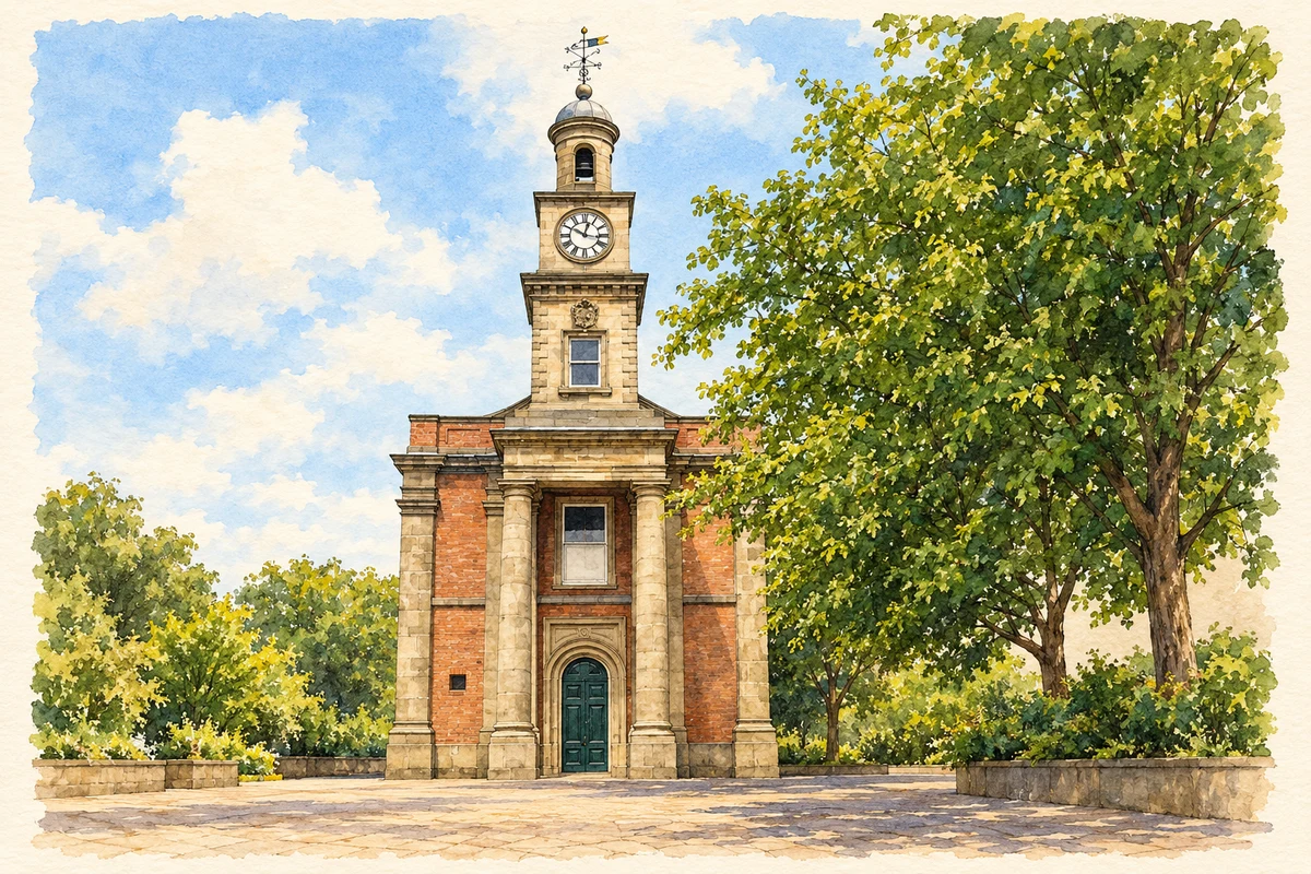
Watercolour and fine ink illustration of Guildhall, Newcastle-under-Lyme
Illustration · Guildhall, Newcastle-under-Lyme
History & heritage

Place & story

A borough around a castle

Newcastle grew around a Norman castle. Henry II granted its charter in 1173, giving residents special rights and freedoms, including market rights. The original document has disappeared: the version shown during the borough’s 850th anniversary was a modern reconstruction. A surviving Trinity Fair charter dates from 1281, keeping later documentary evidence distinct from the lost foundation grant. [2]

A public building at the market’s heart

The Guildhall occupies High Street, the broad commercial street identified by the conurbation’s historic assessment as part of the town’s market landscape. Its fabric records civic rebuilding: Historic England dates the earlier building to 1713 and its remodelling to 1861. The landmark seen today combines those two periods rather than preserving an unchanged Georgian hall. [3] [4]

Red brick walls, stone dressings and a tiled roof give the hall its material character. Tall stone pilasters divide the frontage; at one end a full-height Tuscan portico supports a clock tower and cupola. The rounded opposite end adds another distinctive shape. Such details place public architecture in the same streets where buying and selling gave the borough much of its purpose. [3] [2]

Manufacture and different kinds of home

Newcastle shared in North Staffordshire’s industrial expansion without acquiring the same emphasis as the pottery towns. The 2006 historic assessment identifies textiles and especially hat-making among its industries, while coal and iron exploitation at Knutton and Silverdale lay to the west. Those neighbouring industrial communities belong to the town’s wider economic setting and should retain their own identities. [4]

Housing made the social differences within that economy visible. Terraces accommodated an expanding workforce, while detached villas in substantial grounds formed middle-class suburbs. The assessment describes the resulting mixture as an important distinction within the conurbation. A town with manufacturers and workers also developed a landscape of gardens, substantial houses and older commercial frontages. [4]

Making history part of the town again

In December 2023 the council handed over keys to renovated premises at 23–25 Merrial Street for an Astley centre combining museum, research and teaching functions. This was a practical reuse of an empty council building around a locally connected life. It also joined a wider effort to bring cultural activity into the centre. [5]

Brampton Museum’s 2023 charter exhibition brought the borough’s charters together, including the reconstructed 1173 grant. Collections officer Clare Griffiths subsequently developed its research into a book published in 2024. The episode shows how civic identity depends on continued work with surviving documents, collections and interpretation, as well as on anniversary ceremonies. [2]

Back to contents
Lives connected to this place

Notable people

Philip Astley: Newcastle beginnings, a London career

Philip Astley was born in Newcastle, the son of a cabinet maker. After military service he became known for skilled riding and developed public equestrian entertainments in London, adding performers such as clowns, jugglers and tightrope walkers. His importance to circus history grew from that later career; Newcastle’s claim is specifically his birthplace and early family connection. [5]

Back to contents
A chronology

Timeline

Newcastle through time

  1. 1173 — Henry II grants the borough’s royal charter. [2]

  2. 1281 — The earliest surviving Trinity Fair charter is issued. [2]

  3. 1713 — The earlier Guildhall is built. [3]

  4. 1861 — The Guildhall is remodelled. [3]

  5. 2023 — An anniversary exhibition reunites the borough’s charters. [2]

  6. December 2023 — Keys to the proposed Astley centre premises are handed over. [5]

Back to contents

Population over time

Built-up area · Settlement · Census 2021

Newcastle-under-Lyme

76,505people · 2021

Census 2021 population of the named settlement, using ONS built-up area boundaries.

Published census counts.

Sources: ONS: Towns and cities, characteristics of built-up areas, Census 2021 (Table 1c)

View population figures
Newcastle-under-Lyme — census population
Census yearPopulation
202176,505
Sources and how to read this chart

Usual residents on 21 March 2021; published ONS count rounded to the nearest 5.. Boundary geography: December 2022 (E63001908).

Census 2021 population of the named settlement, using ONS built-up area boundaries.

ONS Table 1c rounds counts to the nearest 5 and suppresses counts below 10. Matched by exact settlement name or individually reviewed district-qualified name, with its coordinate strictly inside that same official BUA boundary. The 2022 BUA geography changed methodology and cannot be directly compared with 2011 BUAs. Contains OS data © Crown copyright and database right 2026. Contains National Statistics data © Crown copyright and database right 2026.

Source: ONS: Towns and cities, characteristics of built-up areas, Census 2021 (Table 1c). Open Government Licence v3.0. Retrieved 2026-10-26. Source: ONS and Ordnance Survey: Built Up Areas December 2022 GB BGG. Open Government Licence v3.0. Retrieved 2026-10-26.

Neighbourhood census context

These figures describe statistical neighbourhoods, which may cover part of a place or include neighbouring places.

Neighbourhood census area · 1971–2021

Newcastle-under-Lyme 011

Population of the area containing the recorded point for Newcastle-under-Lyme, not the whole place. This area may cover part of the place or include neighbours.

02.5k5k7.5k10k1971: 9,361 people19711981: 8,411 people19811991: 7,878 people19912001: 7,698 people20012011: 8,419 people20112021: 8,348 people2021

Includes harmonised historical census estimates.

Sources: ONS · Paul Norman

View population figures
Newcastle-under-Lyme 011 — census population and harmonised historical estimates
Census yearPopulation
19719,361
19818,411
19917,878
20017,698
20118,419
20218,348
Sources and how to read this chart

Usual residents of the containing MSOA; this is local area context, not the population of the named settlement.. Boundary geography: 1 April 2022 (E02006168).

2011 and 2021 census counts harmonised by ONS to the same 1 April 2022 geography. Location matched to ONS 2021 MSOA polygons (full resolution, coastline clipped, V7). ONS exact-fit lookup marks this MSOA unchanged from 2011 (U); historical estimates use that same footprint.

1971–2011: Paul Norman harmonised historical estimates on 2011 MSOAs, rounded to whole residents (1971–1991 are modelled). 2021: ONS census count. The historical 2011 total can differ slightly from the ONS change-over-time 2011 total because of methodology and statistical disclosure controls. These are area estimates, not settlement totals.

Source: ONS Census change over time: usual resident population, 2011 and 2021. Open Government Licence v3.0. Retrieved 2026-10-26. Source: ONS MSOA December 2021 boundaries EW BFC V7. Open Government Licence v3.0. Retrieved 2026-10-26. Source: Paul Norman — Area characteristics: Great Britain 1971 to 2011. Creative Commons Attribution 4.0. Retrieved 2026-10-26. Source: ONS MSOA 2011 to MSOA 2021 exact-fit lookup for England and Wales. Open Government Licence v3.0. Retrieved 2026-10-26.

Recorded locationNewcastle-under-Lyme53.01116° N · 2.22801° WInteractive map loads when this area enters view.
Approximate recorded location · Geographic source

Geographic context

Place type
Town
Country / region
England · West Midlands
County group
Staffordshire
Current administration
Newcastle-under-Lyme
Current administration
Staffordshire
Recorded coordinates
53.01116, -2.22801
OS Open Names ID
osgb4000000074577594

County groups are browsing aids. Current administrative and historic areas are recorded separately.

Recorded names

  • Newcastle-under-Lyme · en · official

Nearby heritage

Distances are from the recorded place point. Proximity does not establish that a site lies within the place boundary or belongs to its history.

Sources & further reading

  1. OS Open Names October 2026 · Source licence.
  2. Medieval charter inspires borough history book · Newcastle-under-Lyme Borough Council
  3. Guildhall: list entry 1196523 · Historic England
  4. North Staffordshire Conurbation: Assessment of Historical Significance · The Conservation Studio for Urban Vision North Staffordshire
  5. Key step forward for circus project · Newcastle-under-Lyme Borough Council
  6. Illustration of Guildhall, Newcastle-under-Lyme, adapted from The Guildhall by Jonathan Kington. CC BY-SA 2.0. AI-assisted watercolour and fine ink adaptation; simplified fine detail and removal of incidental clutter.

Geographic source retrieved 2026-10-26. History last researched 2026-10-26. How this page was prepared.