Town

Atherstone

Atherstone’s hat industry grew within the narrow plots of a medieval market town. Workshops, crowded housing and later clearance left different traces behind the surviving frontages of Long Street.

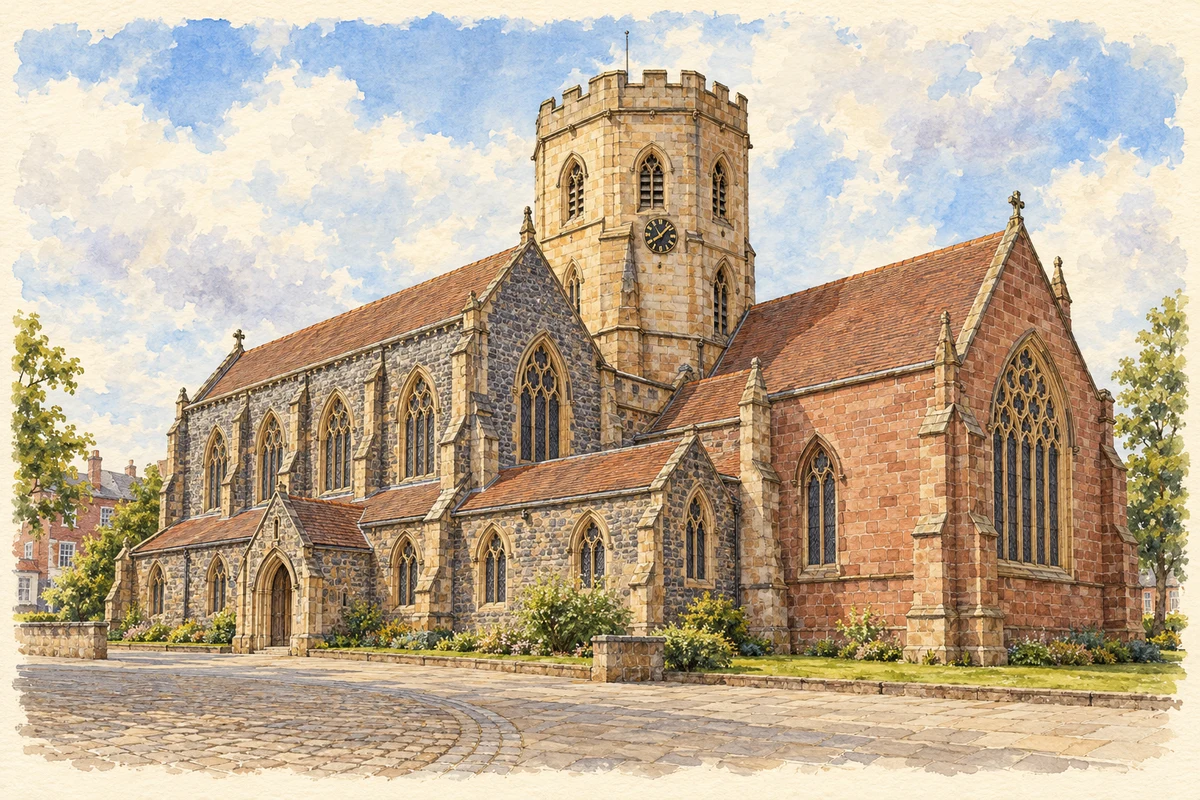
Watercolour and fine ink illustration of St Mary’s Church, Atherstone
Illustration · St Mary’s Church, Atherstone
Original illustration; researched sources
Research sources

Original architectural composition based on the cited building descriptions; incidental setting and fine details are interpretive.

Historic England: St Mary, Atherstone; St Mary’s: Our heritage

History & heritage

Place & story

A market on Watling Street

Atherstone developed beside Watling Street, about a mile west of the Roman fort at Mancetter. That distinction matters: the nearby military site and the later town are separate places. The town also stood close to a packhorse route linking Bristol and Lincoln, placing its market within a wider network of travel. [2]

Hugh, Earl of Chester, gave Atherstone to the Abbey of Bec in Normandy in 1100. Its abbot became lord of the manor, obtained a market charter and laid out burgage plots around the marketplace to attract tenants. These long plots formed a framework that later trades and housing would occupy much more intensively. [2]

A friary church shared with a school

St Mary’s links the marketplace with a different history of institutional reuse. The religious house was refounded for Augustinian friars in 1378, and the church retains a medieval chancel and octagonal tower. The upper part of the tower was rebuilt in 1782, while the nave, aisles and parts of the transepts date from 1849. [6]

After the Dissolution, the nave became a chapel for the town and the chancel housed the grammar school. Education and worship occupied different parts of the former friary church. The school stopped using the chancel in 1863; after a period of dereliction it was restored to church use in 1888. The sequence reveals how an old religious building could accommodate changing community needs. [6] [3]

From tanning to felt hats

Watercourses descending from the wooded land of Arden south of the town supported tanning. Felt hatmaking later displaced it and took over the watercourses, reusing the supply of soft water. Accounts place the beginnings of the hat trade in the sixteenth or seventeenth century, so its development is clearer than a precise founding date. [2] [5]

Hatters initially worked individually in cottages. Later they rented communal workspace in the yards behind Long Street, in workshops known as bow-and-basin shops. Production thus expanded within domestic plots before the factory became its more visible form. By the enclosure of the open fields in 1765, most townspeople depended on trade rather than agriculture. [2]

Industry inside the burgage plots

The hat trade attracted workers from elsewhere, but neighbouring landownership constrained outward expansion. Development filled the plots behind street-front houses, creating Atherstone’s characteristic yards. By the late eighteenth century most burgage plots had been subdivided, and the pressure for housing increased their density. [2]

Factories commonly adapted buildings already standing, including a tannery and an iron foundry, rather than starting with purpose-built premises. The local house-history project records seven hat factories by 1900. This was an industrial town whose workplaces were woven into an older street pattern. [2]

Clearance and what remained

Poor-quality housing crowded the yards, and clearance began in the 1920s, continuing particularly after the Second World War. The removal of these homes changed the interior of the medieval plots even where their street-facing buildings remained. Long Street retained stretches of Georgian and Victorian frontage, while much of the marketplace survived. [2]

Further redevelopment reshaped the edges of the centre. In the late 1970s buildings to the south-east were demolished for North Warwickshire Borough Council offices and Woolpack Way was constructed. In the late 1980s the Vero & Everitt hat factory in Station Street was demolished, and the road realigned for a supermarket. These changes help explain why the historic street frontage and the spaces behind it tell different stories. [2]

Factory lives and street traditions

The Shrove Tuesday Ball Game makes Long Street a place of communal competition as well as work and shopping. Marjorie Service recalled the ball being passed around her factory for workers to sign, shop windows being boarded before play, and spectators throwing sweets from upstairs windows. The same recollection links factory work with preparations for the town carnival. [7] [8]

The game has attracted argument as well as celebration. Newspaper material preserved by Warwickshire Libraries records its first BBC broadcast in 1934, difficult play during the severe winter of 1947 and complaints about injuries and property damage. The often-repeated story of a contest in 1199 belongs to local legend; these newspaper records offer firmer dates for its more recent history. [8]

By the end of the twentieth century Atherstone’s seven factories had all closed, according to the industrial archaeology society. It identifies parts of Hatton’s works in Long Street as a rare survival. Industrial memory also remains in photographs and workers’ testimony: factory closure should not be confused with the disappearance of every trace of hatting. [5] [4]

Back to contents
Lives connected to this place

Notable people

Jean Neville: skill and separation at work

Atherstone worker Jean Neville recalled putting hats on a heated block to achieve the correct size and measuring their ribbons. Her account also describes perforated hats made for the London fashion retailer Biba. This first-person evidence brings the work down to the level of individual tasks and customers, supplementing the history of factories and plots. [4]

Neville also remembered separate women’s and men’s sides of the works and using a bridge over the road between them. Her recollection should be read as one worker’s experience, rather than a description of every factory in every period. It preserves aspects of the industry that the surviving street frontages cannot explain on their own. [4]

Back to contents
A chronology

Timeline

Milestones

  1. 1100: Hugh, Earl of Chester, gives Atherstone to Bec Abbey. [2]

  2. 1378: The religious house is refounded for Augustinian friars. [6]

  3. Sixteenth–seventeenth centuries: Accounts place the development of felt hatmaking in this period. [2] [5]

  4. 1765: The open fields are enclosed; most townspeople now depend on trade. [2]

  5. 1863: The grammar school ceases using the friary church’s chancel. [3]

  6. 1888: The chancel is restored to church use. [6] [3]

  7. By 1900: Seven hat factories are recorded. [2]

  8. From the 1920s: Clearance removes poor-quality yard housing. [2]

  9. 1934: The Ball Game is broadcast by the BBC. [8]

  10. Late 1980s: The Vero & Everitt factory in Station Street is demolished. [2]

Back to contents

Population over time

Built-up area · Settlement · Census 2021

Atherstone

8,665people · 2021

Census 2021 population of the named settlement, using ONS built-up area boundaries.

Published census counts.

Sources: ONS: Towns and cities, characteristics of built-up areas, Census 2021 (Table 1c)

View population figures
Atherstone — census population
Census yearPopulation
20218,665
Sources and how to read this chart

Usual residents on 21 March 2021; published ONS count rounded to the nearest 5.. Boundary geography: December 2022 (E63002733).

Census 2021 population of the named settlement, using ONS built-up area boundaries.

ONS Table 1c rounds counts to the nearest 5 and suppresses counts below 10. Matched by exact settlement name or individually reviewed district-qualified name, with its coordinate strictly inside that same official BUA boundary. The 2022 BUA geography changed methodology and cannot be directly compared with 2011 BUAs. Contains OS data © Crown copyright and database right 2026. Contains National Statistics data © Crown copyright and database right 2026.

Source: ONS: Towns and cities, characteristics of built-up areas, Census 2021 (Table 1c). Open Government Licence v3.0. Retrieved 2026-10-26. Source: ONS and Ordnance Survey: Built Up Areas December 2022 GB BGG. Open Government Licence v3.0. Retrieved 2026-10-26.

Neighbourhood census context

These figures describe statistical neighbourhoods, which may cover part of a place or include neighbouring places.

Neighbourhood census area · 1971–2021

North Warwickshire 003

Population of the area containing the recorded point for Atherstone, not the whole place. This area may cover part of the place or include neighbours.

05k10k15k20k1971: 10,048 people19711981: 10,186 people19811991: 10,554 people19912001: 10,838 people20012011: 11,041 people20112021: 11,738 people2021

Includes harmonised historical census estimates.

Sources: ONS · Paul Norman

View population figures
North Warwickshire 003 — census population and harmonised historical estimates
Census yearPopulation
197110,048
198110,186
199110,554
200110,838
201111,041
202111,738
Sources and how to read this chart

Usual residents of the containing MSOA; this is local area context, not the population of the named settlement.. Boundary geography: 1 April 2022 (E02006470).

2011 and 2021 census counts harmonised by ONS to the same 1 April 2022 geography. Location matched to ONS 2021 MSOA polygons (full resolution, coastline clipped, V7). ONS exact-fit lookup marks this MSOA unchanged from 2011 (U); historical estimates use that same footprint.

1971–2011: Paul Norman harmonised historical estimates on 2011 MSOAs, rounded to whole residents (1971–1991 are modelled). 2021: ONS census count. The historical 2011 total can differ slightly from the ONS change-over-time 2011 total because of methodology and statistical disclosure controls. These are area estimates, not settlement totals.

Source: ONS Census change over time: usual resident population, 2011 and 2021. Open Government Licence v3.0. Retrieved 2026-10-26. Source: ONS MSOA December 2021 boundaries EW BFC V7. Open Government Licence v3.0. Retrieved 2026-10-26. Source: Paul Norman — Area characteristics: Great Britain 1971 to 2011. Creative Commons Attribution 4.0. Retrieved 2026-10-26. Source: ONS MSOA 2011 to MSOA 2021 exact-fit lookup for England and Wales. Open Government Licence v3.0. Retrieved 2026-10-26.

Recorded locationAtherstone52.57722° N · 1.54642° WInteractive map loads when this area enters view.
Approximate recorded location · Geographic source

Geographic context

Place type
Town
Country / region
England · West Midlands
County group
Warwickshire
Current administration
North Warwickshire
Current administration
Warwickshire
Recorded coordinates
52.57722, -1.54642
OS Open Names ID
osgb4000000074568675

County groups are browsing aids. Current administrative and historic areas are recorded separately.

Recorded names

  • Atherstone · en · official

Nearby heritage

Distances are from the recorded place point. Proximity does not establish that a site lies within the place boundary or belongs to its history.

Sources & further reading

  1. OS Open Names October 2026 · Source licence.
  2. The Development of Atherstone · Judy Vero / Our Warwickshire
  3. Atherstone Grammar School, MWA6116 · Warwickshire Historic Environment Record / Our Warwickshire
  4. Hatting in Atherstone · Jean Neville / Our Warwickshire
  5. Hatting Industry · Warwickshire Industrial Archaeology Society
  6. Church of St Mary, Atherstone, MWA269 · Warwickshire Historic Environment Record / Our Warwickshire
  7. The Ball Game and Carnival in Atherstone · Marjorie Service / Our Warwickshire
  8. Curious competitions: Atherstone Ball Game · LibraryOn / Warwickshire Libraries
  9. Original illustration of St Mary’s Church, Atherstone by PlaceHistory. Researched sources are linked beneath the illustration. Original composition from inspected architectural facts; no source photograph copied or used as an image-edit input. Fine detail is interpretive, not a measured survey.

Geographic source retrieved 2026-10-26. History last researched 2026-10-26. How this page was prepared.