Town

Kenilworth

Kenilworth grew around a castle and an Augustinian religious house. Their estates still shape its open spaces, while workshops, market gardens and railway journeys explain the town beyond its famous ruins.

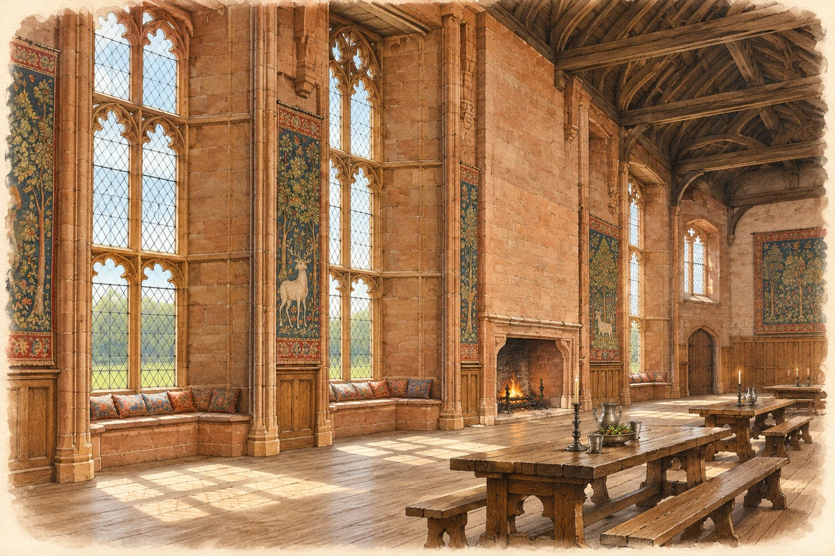
Watercolour and fine ink historical reconstruction of John of Gaunt’s Great Hall, Kenilworth Castle, around 1575
Historical reconstruction · John of Gaunt’s Great Hall, Kenilworth Castle · around 1575
Artistic reconstruction · Around 1575

Artistic recreation based on current evidence: surviving masonry and architectural records inform this view of the Great Hall in use. Lost finishes and furnishings are interpreted.

Evidence and interpreted details

Uncertain details: The roof carpentry, glazing, colours, tapestry designs and furniture arrangement are interpreted; their exact appearance is not established.

Based on: Description of Kenilworth Castle: Inner Court; Kenilworth Castle scheduled monument 1014041, Details

History & heritage

Place & story

Two foundations in one landscape

Geoffrey de Clinton received land from Henry I in about 1120 and divided it between a castle estate and an Augustinian priory. The castle retained its park and lake, while the canons received rights to fish and graze livestock there. The two institutions were neighbours with shared resources, rather than unrelated monuments. [2]

The religious house later became an abbey. Its remains include part of the church and cloister, a sandstone gatehouse and the building traditionally called the Abbey Barn. Historic England cautions that the barn’s original purpose is unknown: the name should not be treated as proof of its medieval use. The surviving buildings and buried archaeology preserve only part of a much larger precinct. [3]

Water, siege and princely display

King John strengthened the castle with walls, towers and work on the dam holding back its lake. In 1266 the garrison resisted Henry III for six months, finally surrendering on 13 December. The expanse of water belonged to the castle’s defensive system as well as to its estate economy. [2]

John of Gaunt’s rebuilding gave Kenilworth a great hall designed for feasting and display. Later kings repaired and adapted it; Henry VIII dismantled an outlying pleasure house and reused its material within the castle. The surviving ruin represents accumulated choices about accommodation and status, as well as military strength. [6]

In 1563 Elizabeth I granted Kenilworth to Robert Dudley, who refashioned it with new windows, gardens and work on the gatehouse. These changes turned a medieval residence towards the architectural expectations of the Tudor court. Rebuilding was part of the castle’s continuing use, before it became a monument admired chiefly for its age. [6]

A town of skins, horns and gardens

Kenilworth’s later trades drew on agricultural materials. Horn comb making, tanning and the preparation of animal skins were important activities, alongside a short-lived manufacture of Prussian blue pigment. Workers’ cottages spread in Mill End and St John’s, while industrialists from Coventry and Birmingham built larger houses. Different kinds of prosperity occupied the same expanding town. [4]

Rail access helped a substantial horticultural industry send fresh produce to more distant markets. Brickmaking supplied the housing growth which accelerated from the 1920s. New schools and churches accompanied earlier nineteenth-century expansion; after the Second World War, planned development added another stage. These working and residential changes belong beside the more conspicuous history of royal visits. [4]

Visitors arrive by train

The railway arrived in 1844, with an approach road to the station. Growing passenger and freight traffic led to enlargement in the 1880s, including new station facilities and more space for goods and coal. Railways served both residents and visitors: castle tourism and the practical movement of commodities shared the same infrastructure. [5]

The station closed in 1965 and reopened in 2018. This interruption is a reminder that Kenilworth’s connections have been repeatedly remade. The surviving line and new station restore a passenger link to a town whose nineteenth-century growth had been closely connected with rail travel. [5]

Ruin, memory and conservation

After the Civil War the castle’s defences were dismantled, its lake drained and saleable fittings removed. Leicester’s Gatehouse survived as a house. Walter Scott’s 1821 novel Kenilworth spread the ruin’s fame, although its romantic plot remains literature rather than evidence for Tudor events. [2]

Twentieth-century destruction also changed the town. In November 1940 a land mine destroyed the Globe Hotel and surrounding buildings at Abbey End, damaging the nearby clock tower. Given in 1906 by G. M. Turner in memory of his wife, the tower connects a personal memorial with the later wartime history of the streets around it. [8]

Back to contents
Lives connected to this place

Notable people

Robert Dudley: a residence for the queen

Dudley’s local relationship was as owner and ambitious patron of the castle. Elizabeth granted him Kenilworth in 1563; his improvements created a courtly residence, and the queen stayed for nineteen days in 1575. His buildings and gardens made royal hospitality visible in the landscape, leaving the best-known Tudor layer of the site. [9]

John Davenport Siddeley: engineering wealth and preservation

Siddeley made his career in the cycle, tyre, motor and aircraft industries around Coventry. In 1937 he bought Kenilworth Castle, placed it in the Ministry of Works’ care and provided money for repairs. His connection is therefore a direct act of preservation, financed by twentieth-century industrial wealth. That same year he became Baron Kenilworth. [7]

Back to contents
A chronology

Timeline

Kenilworth through time

  1. 1120s — Geoffrey de Clinton establishes the castle. [2]

  2. 1266 — The castle garrison surrenders after a six-month siege. [2]

  3. 1538 — The abbey is surrendered during the Dissolution. [8]

  4. 1563 — Robert Dudley receives the castle from Elizabeth I. [6]

  5. 1575 — Elizabeth stays at Kenilworth for nineteen days. [9]

  6. 1821 — Walter Scott publishes Kenilworth. [2]

  7. 1844 — The railway arrives. [5]

  8. 1937 — Siddeley buys the castle and funds repairs. [7]

  9. 1940 — A land mine devastates part of Abbey End. [8]

  10. 1965 / 2018 — The station closes, then reopens. [5]

Back to contents

Population over time

Built-up area · Settlement · Census 2021

Kenilworth

22,235people · 2021

Census 2021 population of the named settlement, using ONS built-up area boundaries.

Published census counts.

Sources: ONS: Towns and cities, characteristics of built-up areas, Census 2021 (Table 1c)

View population figures
Kenilworth — census population
Census yearPopulation
202122,235
Sources and how to read this chart

Usual residents on 21 March 2021; published ONS count rounded to the nearest 5.. Boundary geography: December 2022 (E63003152).

Census 2021 population of the named settlement, using ONS built-up area boundaries.

ONS Table 1c rounds counts to the nearest 5 and suppresses counts below 10. Matched by exact settlement name or individually reviewed district-qualified name, with its coordinate strictly inside that same official BUA boundary. The 2022 BUA geography changed methodology and cannot be directly compared with 2011 BUAs. Contains OS data © Crown copyright and database right 2026. Contains National Statistics data © Crown copyright and database right 2026.

Source: ONS: Towns and cities, characteristics of built-up areas, Census 2021 (Table 1c). Open Government Licence v3.0. Retrieved 2026-10-26. Source: ONS and Ordnance Survey: Built Up Areas December 2022 GB BGG. Open Government Licence v3.0. Retrieved 2026-10-26.

Neighbourhood census context

These figures describe statistical neighbourhoods, which may cover part of a place or include neighbouring places.

Neighbourhood census area · 1971–2021

Warwick 001

Population of the area containing the recorded point for Kenilworth, not the whole place. This area may cover part of the place or include neighbours.

02.3k4.5k6.8k9k1971: 8,355 people19711981: 7,646 people19811991: 7,164 people19912001: 7,516 people20012011: 7,566 people20112021: 7,993 people2021

Includes harmonised historical census estimates.

Sources: ONS · Paul Norman

View population figures
Warwick 001 — census population and harmonised historical estimates
Census yearPopulation
19718,355
19817,646
19917,164
20017,516
20117,566
20217,993
Sources and how to read this chart

Usual residents of the containing MSOA; this is local area context, not the population of the named settlement.. Boundary geography: 1 April 2022 (E02006519).

2011 and 2021 census counts harmonised by ONS to the same 1 April 2022 geography. Location matched to ONS 2021 MSOA polygons (full resolution, coastline clipped, V7). ONS exact-fit lookup marks this MSOA unchanged from 2011 (U); historical estimates use that same footprint.

1971–2011: Paul Norman harmonised historical estimates on 2011 MSOAs, rounded to whole residents (1971–1991 are modelled). 2021: ONS census count. The historical 2011 total can differ slightly from the ONS change-over-time 2011 total because of methodology and statistical disclosure controls. These are area estimates, not settlement totals.

Source: ONS Census change over time: usual resident population, 2011 and 2021. Open Government Licence v3.0. Retrieved 2026-10-26. Source: ONS MSOA December 2021 boundaries EW BFC V7. Open Government Licence v3.0. Retrieved 2026-10-26. Source: Paul Norman — Area characteristics: Great Britain 1971 to 2011. Creative Commons Attribution 4.0. Retrieved 2026-10-26. Source: ONS MSOA 2011 to MSOA 2021 exact-fit lookup for England and Wales. Open Government Licence v3.0. Retrieved 2026-10-26.

Recorded locationKenilworth52.34256° N · 1.57910° WInteractive map loads when this area enters view.
Approximate recorded location · Geographic source

Geographic context

Place type
Town
Country / region
England · West Midlands
County group
Warwickshire
Current administration
Warwick
Current administration
Warwickshire
Recorded coordinates
52.34256, -1.57910
OS Open Names ID
osgb4000000074556602

County groups are browsing aids. Current administrative and historic areas are recorded separately.

Recorded names

  • Kenilworth · en · official

Nearby heritage

Distances are from the recorded place point. Proximity does not establish that a site lies within the place boundary or belongs to its history.

Sources & further reading

  1. OS Open Names October 2026 · Source licence.
  2. History of Kenilworth Castle · English Heritage
  3. Kenilworth Abbey, scheduled monument 1021079 · Historic England
  4. Kenilworth: A Guide to Conservation Areas · Warwick District Council
  5. Kenilworth Station and Approach circa 1900s · Warwickshire County Council Library and Information Service
  6. Kenilworth Castle (part one) · The National Archives
  7. Meet The Man Who Saved Kenilworth Castle · English Heritage, Martin Allfrey
  8. Kenilworth: History and heritage · Warwick District Council
  9. Kenilworth Castle: History and Stories · English Heritage
  10. Illustration of John of Gaunt’s Great Hall, Kenilworth Castle, adapted from Kenilworth Castle - Great Hall.jpg by Damek / Adam Piontek. CC BY 2.0. AI-assisted historical reconstruction; intact fabric restored, colour and lighting added, missing finishes and furnishings interpreted.

Geographic source retrieved 2026-10-26. History last researched 2026-10-27. How this page was prepared.