Town

Rugby

Rugby grew through education, transport and engineering. Its schools, factories and research laboratories connected a market town to much wider worlds.

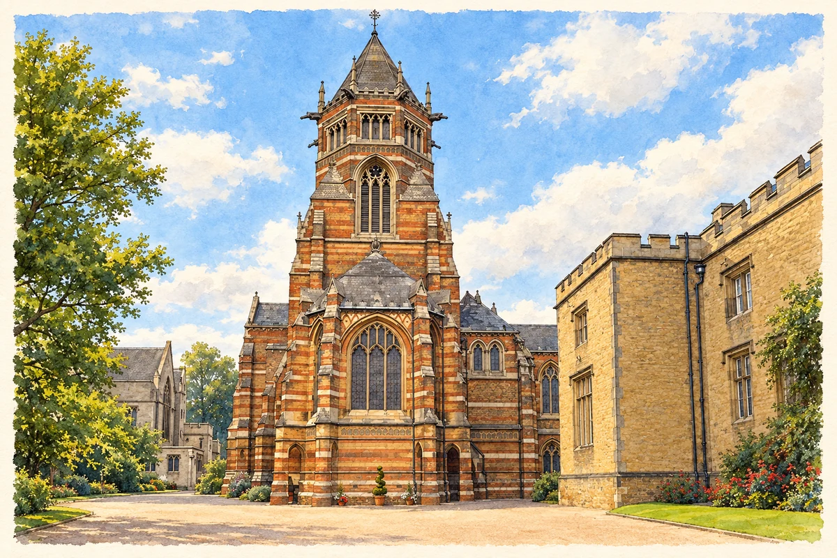
Watercolour and fine ink illustration of Rugby School Chapel
Illustration · Rugby School Chapel
History & heritage

Place & story

A market and a school

Rugby appears in Domesday Book in 1086 and received a market charter in 1255. Its later history has several overlapping centres: the market streets, the school and the industrial districts that developed with new transport connections. The Oxford Canal and the railways enlarged the reach of a settlement that had previously served its agricultural surroundings. [2]

In 1567 Lawrence Sheriff’s will established the endowment from which Rugby School developed. His trustees founded a free grammar school for boys of Rugby and Brownsover. By the late seventeenth century the school was attracting pupils from other counties; in 1750 it moved to the site of School House and The Close. The local foundation gained a wider intake. [3]

Materials move, factories follow

Canal transport helped turn local limestone into a larger business, bringing fuel in and taking burnt lime out. Walker established lime works at Newbold in 1776 and cement works at New Bilton in 1865. The railway then enlarged the market for building materials and cattle. The London–Birmingham line opened in 1838, followed by a route towards Nottingham and Derby in 1840. [4]

Engineering developed alongside these connections. Railway workshops expanded in the 1890s. Willans and Robinson arrived in 1899 to make high-speed steam engines for electricity generation, and British Thomson-Houston opened its Mill Road works in 1902, producing motors and generators. Both firms entered turbine manufacture. Rugby’s industrial identity increasingly concerned the machinery that produced and used electrical power. [4]

The local history group records redevelopment of former central factory sites, often for housing, while motorway connections encouraged development to the north. Transport remained significant as industrial land changed use. [4]

From electrical machinery to new research

British Thomson-Houston supplied more than a factory setting. In his Nobel lecture Dennis Gabor recalled working in its Rugby research laboratory in 1947, investigating electron microscopy when the idea of holography emerged. He explained that the link to microscopes mattered in obtaining permission for experiments: BTH was an electrical engineering company, while its sister company Metropolitan Vickers made electron microscopes. A later optical technique grew from a specific industrial research problem. [5]

Aircraft propulsion was another experiment drawing on the town’s engineering capacity. Frank Whittle approached BTH to prepare drawings for his engine, and the experimental WU ran at its Rugby works on 12 April 1937. Erratic early operation prompted a move of testing to a disused BTH foundry at Lutterworth in 1938. Offices were later rented at Brownsover Hall. Rugby and Lutterworth played complementary roles in the programme. [7]

The school and the town’s sporting name

Rugby School preserves the setting in which rugby football developed. It commemorates William Webb Ellis and the traditional story of his running with the ball in 1823. That single-event account should be treated as a tradition. The chapel, School House and The Close form its historic landscape. [3]

The sport also produced work beyond the school gates. The borough’s visitor guide identifies the St Matthew’s Street premises to which the Gilbert boot and shoemaking business moved in 1842 to expand football manufacture. The museum there explains the changing construction of the ball. Sporting heritage is therefore also a story of local craft, products and commercial adaptation. [2]

Back to contents
Lives connected to this place

Notable people

Thomas Arnold: authority and education

Thomas Arnold was Rugby School’s headmaster from 1828 to 1842. He gave senior boys greater duties and responsibilities and made private access to the headmaster part of school life. His local connection was a working career in education. His burial beneath the chapel’s chancel steps keeps that association within the school’s fabric. [3]

Frank Whittle: an engine tested here

Frank Whittle was born in Coventry, but his connection to Rugby was practical engineering. The BTH works provided drawings, manufacture and the setting for the first run of his experimental engine in 1937. The later move of testing to Lutterworth and offices to Brownsover Hall shows development spread across more than one site; the achievement should not be compressed into a claim that every stage happened in Rugby. [7]

Dennis Gabor: a laboratory and a new way of imaging

Dennis Gabor moved to England in 1934 to work for British Thomson-Houston in Rugby. The Science Museum dates his invention of holography to 1947 and records his later career at Imperial College London. His association with the town rests on research and employment, rather than birth. His own Nobel lecture identifies the Rugby laboratory as the setting for the original idea. [6] [5]

Back to contents
A chronology

Timeline

Rugby through time

  1. 1255 — Rugby receives a market charter. [2]

  2. 1567 — Lawrence Sheriff’s will provides the school’s foundation. [3]

  3. 1750 — Rugby School moves to its present central site. [3]

  4. 1838 — The London–Birmingham railway opens through Rugby. [4]

  5. 1902 — BTH opens its Mill Road works. [4]

  6. 12 April 1937 — Whittle’s experimental WU engine first runs at BTH in Rugby. [7]

  7. 1947 — Gabor develops the idea of holography while working in the Rugby laboratory. [5]

Back to contents

Population over time

Built-up area · Settlement · Census 2021

Rugby

78,120people · 2021

Census 2021 population of the named settlement, using ONS built-up area boundaries.

Published census counts.

Sources: ONS: Towns and cities, characteristics of built-up areas, Census 2021 (Table 1c)

View population figures
Rugby — census population
Census yearPopulation
202178,120
Sources and how to read this chart

Usual residents on 21 March 2021; published ONS count rounded to the nearest 5.. Boundary geography: December 2022 (E63003068).

Census 2021 population of the named settlement, using ONS built-up area boundaries.

ONS Table 1c rounds counts to the nearest 5 and suppresses counts below 10. Matched by exact settlement name or individually reviewed district-qualified name, with its coordinate strictly inside that same official BUA boundary. The 2022 BUA geography changed methodology and cannot be directly compared with 2011 BUAs. Contains OS data © Crown copyright and database right 2026. Contains National Statistics data © Crown copyright and database right 2026.

Source: ONS: Towns and cities, characteristics of built-up areas, Census 2021 (Table 1c). Open Government Licence v3.0. Retrieved 2026-10-26. Source: ONS and Ordnance Survey: Built Up Areas December 2022 GB BGG. Open Government Licence v3.0. Retrieved 2026-10-26.

Neighbourhood census context

These figures describe statistical neighbourhoods, which may cover part of a place or include neighbouring places.

Neighbourhood census area · 1971–2021

Rugby 009

Population of the area containing the recorded point for Rugby, not the whole place. This area may cover part of the place or include neighbours.

01.8k3.5k5.3k7k1971: 6,804 people19711981: 5,524 people19811991: 5,632 people19912001: 5,560 people20012011: 5,872 people20112021: 6,103 people2021

Includes harmonised historical census estimates.

Sources: ONS · Paul Norman

View population figures
Rugby 009 — census population and harmonised historical estimates
Census yearPopulation
19716,804
19815,524
19915,632
20015,560
20115,872
20216,103
Sources and how to read this chart

Usual residents of the containing MSOA; this is local area context, not the population of the named settlement.. Boundary geography: 1 April 2022 (E02006500).

2011 and 2021 census counts harmonised by ONS to the same 1 April 2022 geography. Location matched to ONS 2021 MSOA polygons (full resolution, coastline clipped, V7). ONS exact-fit lookup marks this MSOA unchanged from 2011 (U); historical estimates use that same footprint.

1971–2011: Paul Norman harmonised historical estimates on 2011 MSOAs, rounded to whole residents (1971–1991 are modelled). 2021: ONS census count. The historical 2011 total can differ slightly from the ONS change-over-time 2011 total because of methodology and statistical disclosure controls. These are area estimates, not settlement totals.

Source: ONS Census change over time: usual resident population, 2011 and 2021. Open Government Licence v3.0. Retrieved 2026-10-26. Source: ONS MSOA December 2021 boundaries EW BFC V7. Open Government Licence v3.0. Retrieved 2026-10-26. Source: Paul Norman — Area characteristics: Great Britain 1971 to 2011. Creative Commons Attribution 4.0. Retrieved 2026-10-26. Source: ONS MSOA 2011 to MSOA 2021 exact-fit lookup for England and Wales. Open Government Licence v3.0. Retrieved 2026-10-26.

Recorded locationRugby52.37218° N · 1.26265° WInteractive map loads when this area enters view.
Approximate recorded location · Geographic source

Geographic context

Place type
Town
Country / region
England · West Midlands
County group
Warwickshire
Current administration
Rugby
Current administration
Warwickshire
Recorded coordinates
52.37218, -1.26265
OS Open Names ID
osgb4000000074569820

County groups are browsing aids. Current administrative and historic areas are recorded separately.

Recorded names

  • Rugby · en · official

Nearby heritage

Distances are from the recorded place point. Proximity does not establish that a site lies within the place boundary or belongs to its history.

Sources & further reading

  1. OS Open Names October 2026 · Source licence.
  2. The Rugby Town Visitor Guide · Rugby Borough Council
  3. Our History · Rugby School
  4. Industrial Town: From1836 to now · Rugby Local History Research Group
  5. Dennis Gabor Nobel Lecture · Dennis Gabor / Nobel Foundation
  6. Dennis Gabor1900–1979 · Science Museum Group
  7. Sir Frank Whittle · Lutterworth and District Museum
  8. Illustration of Rugby School Chapel, adapted from Rugby School Chapel (geograph 3039658).jpg by Ian Rob. CC BY-SA 2.0. AI-assisted watercolour and fine ink adaptation; incidental clutter simplified, warm cream paper margins. Architectural forms follow the inspected reference.

Geographic source retrieved 2026-10-26. History last researched 2026-10-27. How this page was prepared.