Town

Stratford-upon-Avon

Medieval plots and institutions shaped Stratford before Shakespeare. His family’s working home and later investments connect that town with the museums, theatres and restored waterway that now bring its past into public life.

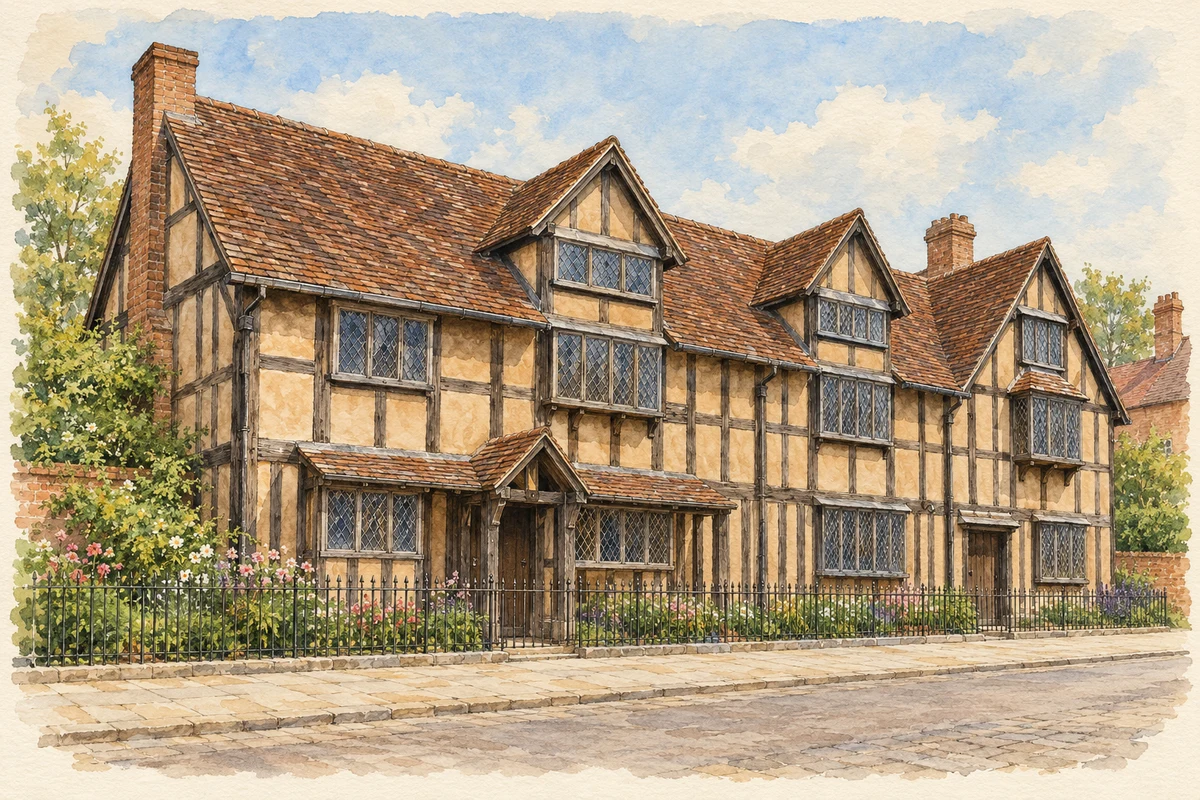
Watercolour and fine ink illustration of Shakespeare’s Birthplace, Henley Street
Illustration · Shakespeare’s Birthplace, Henley Street
Original illustration; researched sources
Research sources

Original architectural composition based on the cited building descriptions; incidental setting and fine details are interpretive.

Historic England: Shakespeare’s Birthplace; Shakespeare Birthplace Trust: About the Birthplace

History & heritage

Place & story

A town laid out for trade

Stratford’s familiar centre rests on a plan older than its literary fame. A royal charter established market-town status in 1196, followed by the marking out of property plots and streets. The Town Design Statement identifies that layout as the foundation of the present centre. Its enduring pattern gives a framework to later timber houses, shops and institutions. [3]

The river crossing was another essential part of that town. Clopton Bridge dates from the late fifteenth century: Historic England places it around 1484 and records fourteen arches. Later generations widened it in 1814 and added a cast-iron footway in 1827, made by Birmingham’s Eagle Foundry. A medieval structure was adapted as the demands of traffic and pedestrians changed. [4]

The guild’s town

The Guild of the Holy Cross was a religious association with practical responsibilities. Its prosperity supported a chapel, schoolhouse, Guildhall and almshouses; members endowed it in the expectation that priests would pray for them after death. When the guild was suppressed in the Reformation, Stratford lost an institution deeply involved in civic life. A charter of incorporation in 1553 returned much former guild property to the town corporation. [5]

The school’s own history traces an educational presence to a recorded schoolmaster in 1295 and an independent endowment from Thomas Jolyffe in 1482. Edward VI’s charter secured its future. That continuity matters alongside the political and religious change: buildings and income could pass between institutions while education remained part of the town’s daily life. [6]

Colour, belief and the Guild Chapel

The Guild Chapel’s wall paintings made religious teaching visible through saints and scenes of the afterlife. The chapel’s information sheet records John Shakespeare authorising payment for defacing images in 1563–64, following the Elizabethan injunction against them. It also acknowledges uncertainty about when all the paintings were covered. Their survival beneath later coatings offers evidence of religious change without telling us exactly what the young William could have seen. [5]

A working home in Henley Street

John Shakespeare lived and made gloves in the house now called Shakespeare’s Birthplace. He became the town’s high bailiff in 1568, combining a skilled trade with public office. William, born in 1564, grew up in this household. The building is therefore evidence of a family’s work and local standing as well as a place associated with a future playwright. [2]

The house continued to change after William’s childhood. He inherited it following John’s death in 1601, and the adjoining small cottage was leased to his sister Joan Hart. Other parts became an inn. The property’s later life complicates the idea of a home preserved at a single moment: family inheritance, tenancy and commercial use all belong to its history. [2]

New Place and a continuing stake in Stratford

Success in London allowed Shakespeare to purchase New Place in 1597. Hugh Clopton had built the earlier house in the 1480s, opposite the Guild Chapel. The purchase made the playwright an owner of a substantial property in his home town. Following his death in 1616, New Place passed to his daughter Susanna and her husband, John Hall; his widow Anne continued living with them. [8]

The house did not survive as the Birthplace did. The Cloptons later replaced Shakespeare’s building, and that replacement was demolished in 1759. The Birthplace Trust assumed responsibility for the site and neighbouring Nash’s House in 1876. Excavations in 2010–15 helped investigate the lost property. Here, archaeology and the surviving site carry a story whose principal building has disappeared. [8]

A waterway made useful again

The Stratford-upon-Avon Canal reached its junction with the Avon in 1816. Its route connected the town with the Birmingham canal system. Trade peaked in 1838 before railway competition took business away. The later threat of abandonment prompted canal enthusiasts to defend navigation; their evidence of recent boat journeys helped prevent the waterway being closed. [9]

Restoration brought together volunteer effort and public institutions. Under David Hutchings, workers included waterways-society volunteers, members of the armed services and prisoners from Winson Green. The southern section reopened on 11 July 1964. Canal & River Trust’s archive records National Trust ownership from 1960 and the later transfer to British Waterways in 1988. The working route became a preserved waterway through deliberate organisation and physical labour. [9] [10]

Preserving Shakespeare, performing Shakespeare

When the Birthplace came onto the market, a public campaign supported by Charles Dickens helped secure it. The Shakespeare Committee paid £3,000 at auction in 1847; the organisation became the Shakespeare Birthplace Trust in 1891. Preservation gave public access and institutional care to a building that had passed through several family and commercial uses. [2]

Theatre created a different way to sustain the association. Local brewer Charles Flower donated land and promoted the Shakespeare Memorial Theatre, which opened beside the Avon in 1879. Fire devastated the original theatre in 1926, and its replacement opened in 1932. Peter Hall founded the Royal Shakespeare Company in 1961. The new company’s work made Stratford a place of continuing theatrical production as well as remembrance. [11]

The stages continued to change. The Other Place began in a former store and rehearsal room in 1974, with Buzz Goodbody as its first artistic director; the Swan opened within the surviving shell of the earlier Memorial Theatre in 1986. Different spaces allowed the theatre district to grow through adaptation, keeping parts of older buildings in active use. [11]

Back to contents
Lives connected to this place

Notable people

William Shakespeare: a local life with gaps

William Shakespeare’s strongest local ties are documented through family, property and church records. He was born in Stratford in 1564; the exact birthday is unknown, although 23 April is traditional. He almost certainly attended the town’s grammar school. His acting and writing career developed in London, while property purchases and family life kept him connected to Stratford. He died in 1616. [7]

Hugh Clopton: wealth returned to a town

Hugh Clopton was a wealthy guild member and London lord mayor whose benefactions materially changed Stratford. The bridge was built for him, and his will of 1496 helped fund work at the Guild Chapel. He also built New Place, later bought by Shakespeare. His importance here lies in the buildings and endowments he supported, linking metropolitan mercantile wealth with the fabric of a provincial town. [4] [5] [8]

Elisabeth Scott: designing a new theatre

Elisabeth Scott’s association with Stratford was architectural. She won the open competition following the 1926 fire, designing the theatre that opened in 1932. Historic England describes a modern building with a curved foyer and a broad spiral staircase. Later criticism of the auditorium led to repeated alterations, while Scott’s public spaces and principal facades became important elements to retain. [12]

The redevelopment undertaken in 2007–11 inserted a thrust-stage auditorium within the existing building while preserving significant parts of Scott’s design and the Victorian theatre complex. The building now holds several periods of theatre architecture together. Scott’s contribution survives within that changing workplace rather than as an unaltered design. [12]

Back to contents
A chronology

Timeline

Stratford-upon-Avon through time

  1. 1196 — A royal charter establishes Stratford’s market-town status. [3]

  2. c.1484 — Clopton Bridge is built across the Avon. [4]

  3. 1553 — A charter of incorporation transfers former guild property to the town corporation and secures the school’s future. [6]

  4. 1563–64 — John Shakespeare authorises payment for defacing images in the Guild Chapel. [5]

  5. 1564 — William Shakespeare is born in Stratford. [7]

  6. 1597 — Shakespeare buys New Place. [8]

  7. 1816 — The completed canal opens at its junction with the River Avon. [9]

  8. 1847 — The Shakespeare Committee purchases the Birthplace at auction. [2]

  9. 1879 — The Shakespeare Memorial Theatre opens beside the river. [11]

  10. 1926 / 1932 — Fire devastates the theatre; Elisabeth Scott’s replacement opens six years later. [12]

  11. 1961 — Peter Hall founds the Royal Shakespeare Company. [11]

  12. 11 July 1964 — The restored southern canal reopens to navigation. [9]

  13. 1986 — The Swan Theatre opens within the former Memorial Theatre’s shell. [11]

Back to contents

Population over time

Built-up area · Settlement · Census 2021

Stratford-upon-Avon

28,120people · 2021

Census 2021 population of the named settlement, using ONS built-up area boundaries.

Published census counts.

Sources: ONS: Towns and cities, characteristics of built-up areas, Census 2021 (Table 1c)

View population figures
Stratford-upon-Avon — census population
Census yearPopulation
202128,120
Sources and how to read this chart

Usual residents on 21 March 2021; published ONS count rounded to the nearest 5.. Boundary geography: December 2022 (E63003502).

Census 2021 population of the named settlement, using ONS built-up area boundaries.

ONS Table 1c rounds counts to the nearest 5 and suppresses counts below 10. Matched by exact settlement name or individually reviewed district-qualified name, with its coordinate strictly inside that same official BUA boundary. The 2022 BUA geography changed methodology and cannot be directly compared with 2011 BUAs. Contains OS data © Crown copyright and database right 2026. Contains National Statistics data © Crown copyright and database right 2026.

Source: ONS: Towns and cities, characteristics of built-up areas, Census 2021 (Table 1c). Open Government Licence v3.0. Retrieved 2026-10-26. Source: ONS and Ordnance Survey: Built Up Areas December 2022 GB BGG. Open Government Licence v3.0. Retrieved 2026-10-26.

Neighbourhood census context

These figures describe statistical neighbourhoods, which may cover part of a place or include neighbouring places.

Neighbourhood census area · 1971–2021

Stratford-on-Avon 011

Population of the area containing the recorded point for Stratford-upon-Avon, not the whole place. This area may cover part of the place or include neighbours.

02.5k5k7.5k10k1971: 6,729 people19711981: 6,219 people19811991: 7,700 people19912001: 7,766 people20012011: 9,070 people20112021: 8,863 people2021

Includes harmonised historical census estimates.

Sources: ONS · Paul Norman

View population figures
Stratford-on-Avon 011 — census population and harmonised historical estimates
Census yearPopulation
19716,729
19816,219
19917,700
20017,766
20119,070
20218,863
Sources and how to read this chart

Usual residents of the containing MSOA; this is local area context, not the population of the named settlement.. Boundary geography: 1 April 2022 (E02006514).

2011 and 2021 census counts harmonised by ONS to the same 1 April 2022 geography. Location matched to ONS 2021 MSOA polygons (full resolution, coastline clipped, V7). ONS exact-fit lookup marks this MSOA unchanged from 2011 (U); historical estimates use that same footprint.

1971–2011: Paul Norman harmonised historical estimates on 2011 MSOAs, rounded to whole residents (1971–1991 are modelled). 2021: ONS census count. The historical 2011 total can differ slightly from the ONS change-over-time 2011 total because of methodology and statistical disclosure controls. These are area estimates, not settlement totals.

Source: ONS Census change over time: usual resident population, 2011 and 2021. Open Government Licence v3.0. Retrieved 2026-10-26. Source: ONS MSOA December 2021 boundaries EW BFC V7. Open Government Licence v3.0. Retrieved 2026-10-26. Source: Paul Norman — Area characteristics: Great Britain 1971 to 2011. Creative Commons Attribution 4.0. Retrieved 2026-10-26. Source: ONS MSOA 2011 to MSOA 2021 exact-fit lookup for England and Wales. Open Government Licence v3.0. Retrieved 2026-10-26.

Recorded locationStratford-upon-Avon52.19269° N · 1.70635° WInteractive map loads when this area enters view.
Approximate recorded location · Geographic source

Geographic context

Place type
Town
Country / region
England · West Midlands
County group
Warwickshire
Current administration
Stratford-on-Avon
Current administration
Warwickshire
Recorded coordinates
52.19269, -1.70635
OS Open Names ID
osgb4000000074546824

County groups are browsing aids. Current administrative and historic areas are recorded separately.

Recorded names

  • Stratford-upon-Avon · en · official

Nearby heritage

Explore recorded heritage in Stratford-upon-Avon and the surrounding area. This selection is based on proximity to a recorded settlement point; it is not a complete inventory or evidence that a site lies within the settlement or belongs to its history.

Heritage locationsStratford-upon-Avon & surrounding areaInteractive map loads when this area enters view. Source records are listed below.

Numbered markers match the source records below. Locations are recorded reference points, not site boundaries.

  1. 1, HIGH STREET · Listed building
  2. 2 AND 3, HIGH STREET · Listed building
  3. 39 AND 39A, HIGH STREET · Listed building
  4. 1 AND 2, WOOD STREET (See details for further address information) · Listed building
  5. 17,18 AND 19, BRIDGE STREET · Listed building
  6. BARCLAYS BANK · Listed building
  7. 4 AND 5, HIGH STREET · Listed building
  8. 21, BRIDGE STREET · Listed building

Sources & further reading

  1. OS Open Names October 2026 · Source licence.
  2. Shakespeare’s Birthplace · Shakespeare Birthplace Trust
  3. Stratford-upon-Avon Town Design Statement (2002), section4 · Community Management Group; Stratford-on-Avon District Council
  4. Clopton Bridge and Attached Former Toll House: list entry1204167 · Historic England
  5. The Guild Chapel: English information sheet · Stratford Town Trust / Guild Chapel
  6. History of the School · King Edward VI School, Stratford-upon-Avon
  7. Shakespeare’s life · Folger Shakespeare Library
  8. About Shakespeare’s New Place · Philip Watson / Shakespeare Birthplace Trust
  9. History of the Stratford-upon-Avon Canal · Stratford-upon-Avon Canal Society
  10. BW115: National Trust South Midlands Area records · Canal & River Trust
  11. History & Collections · Royal Shakespeare Company
  12. Royal Shakespeare Theatre: list entry1207396 · Historic England
  13. Original illustration of Shakespeare’s Birthplace, Henley Street by PlaceHistory. Researched sources are linked beneath the illustration. Original composition from inspected architectural facts; no source photograph copied or used as an image-edit input. Fine detail is interpretive, not a measured survey.

Geographic source retrieved 2026-10-26. History last researched 2026-10-26. How this page was prepared.