Warwick’s castle, churches and guild buildings record several kinds of authority. Fire transformed its centre in 1694, while charitable communities, civic institutions and the later canal gave older buildings and streets continuing work to do.
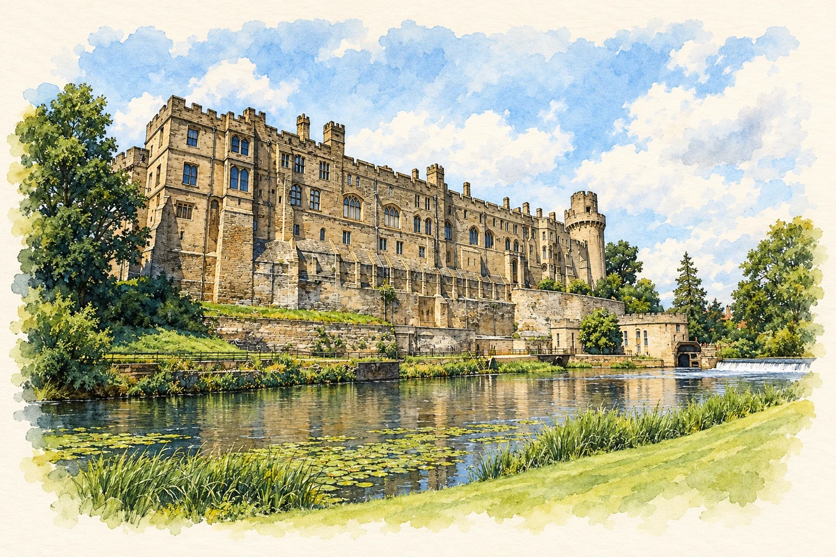
Illustration · Warwick Castle
History & heritage
Place & story
Defence and lordship above the Avon
Warwick’s first fortified settlement dates to 914, and the Norman castle followed in 1068. The earls controlled the medieval town, whose gates regulated its approaches; Eastgate and Westgate survive from that defensive landscape. The castle later developed from a stone stronghold into a country residence. Its commanding appearance preserves successive uses of power, rather than a building that remained unchanged after the Norman Conquest.[2]
The earls’ other monument: St Mary’s
The Beauchamp earls invested in St Mary’s as well as the castle. The church’s medieval chancel and the Beauchamp Chapel made worship and dynastic remembrance part of the same setting. Built from 1441 to about 1455 for the tomb of Richard Beauchamp, the chapel is a conspicuous statement of family status. A church monument could preserve authority and reputation long after its patron’s death.[3]
Guild halls become a home for veterans
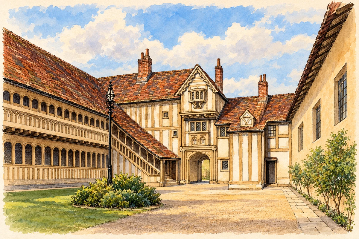
The Lord Leycester buildings began as the headquarters of Warwick’s guilds, with rooms for meetings, banqueting, storage and lodging. Their courtyard brings together ranges of different dates, including a late-medieval Guildhall and a Master’s House. Heavy timber framing and close-set studs give the complex a distinctive character, but its survival also depended on repeated changes of purpose.[4][5]
In 1571 Robert Dudley, Earl of Leicester, established a hospital here for a Master and twelve Brethren. Hospital in this context meant charitable accommodation. The first residents, former soldiers, lived in simple partitions within the halls and received a home and allowance within a regulated community. The buildings therefore connect medieval corporate life with a later response to the needs of military veterans.[4][6]
Historical reconstruction · Lord Leycester Hospital courtyard
Artistic reconstruction · Undated historic print after Charles Pye
An artistic recreation based on an undated historic print after Charles Pye, held by the Wellcome Collection. It represents the courtyard as illustrated in that source, not an exact view for a particular year or its present condition.
Evidence and interpreted details
Uncertain details: Colours, small architectural details, the open gateway, planting and light are interpretive. The print is itself an artistic view rather than a measured survey.
The Great Fire of 1694 destroyed much of central Warwick and prompted a ban on thatched roofing. St Mary’s lost its nave, transepts and tower, while the chancel, chapter house and Beauchamp Chapel survived. Rebuilding began in 1697. The church makes the fire’s uneven consequences visible: medieval and later architecture remain joined within a single building.[2][3]
Charitable housing was affected too. Oken’s almshouses in Pebble Lane burned, and replacements were built in 1696 on land associated with Nicholas Eyffler’s foundation at Castle Hill. The disaster altered where people received support as well as changing the town’s appearance. Rebuilding was a practical work of rehousing and restoring institutions, alongside the creation of new streetscapes.[7]
A new civic room at the crossroads
Work on Francis Smith’s Court House began in 1725, creating a sandstone civic building at Warwick’s central crossroads. Its statue of Justice and royal and town crests announced its public purpose. The building also became a setting for balls, assemblies, dinners and meetings. Government and sociability occupied the same premises, making the Court House part of the rebuilt town’s shared life.[8][9]
A canal terminus becomes another kind of public space
The Saltisford Arm was built in the 1790s as the terminus of the Warwick and Birmingham Canal. It placed the town on a new transport connection with the industrial Midlands. Later dereliction was followed by volunteer restoration, creating moorings, gardens and orchards. Its present green setting is therefore the outcome of work on a former transport site, adding a quieter layer to Warwick’s history of building and adaptation.[10]
The county gathered inside the Market Hall
The seventeenth-century Market Hall now houses collections of Warwickshire archaeology and natural history. Among them is a late-sixteenth-century tapestry map commissioned by Ralph Sheldon for his house at Weston, near Long Compton. It was one of four county maps intended to hang together as a continuous view between London and the Bristol Channel. Its presence in Warwick reflects the work of a county museum; the map was not originally made for the town’s Market Hall.[12][11]
Thomas Oken: wealth turned into continuing obligations
Oken was a Warwick mercer, guild master and civic officer. His will provided for a schoolmaster, payments to poor residents, street paving, repairs to wells and a bridge, and almshouses. The range of these provisions reveals how private wealth could support the everyday operation of a town. His significance lies in those practical obligations as well as in the name preserved by his charity.[7]
Nicholas Eyffler: a glazier who settled in Warwick
Eyffler came from Osnabrück and developed a successful glazing business, living in Warwick’s market area and later Jury Street. His will directed the conversion and extension of timber-framed barns at what is now Castle Hill into almshouses. This was a local contribution by an immigrant craftsman and businessman, whose charitable legacy later became closely joined with Oken’s.[7]
Fulke Greville: a new owner for an old castle
James I granted Warwick Castle to Greville in 1604. He restored the buildings and laid out gardens, adapting a stronghold as an elite residence. The county record office’s archive preserves evidence of the estate and household as well as the family, offering a way to investigate the people who worked within this aristocratic setting.[13][14]
Warwick 011 — census population and harmonised historical estimates
Census year
Population
1971
5,943
1981
7,800
1991
7,613
2001
8,338
2011
11,299
2021
12,697
Sources and how to read this chart
Usual residents of the containing MSOA; this is local area context, not the population of the named settlement.. Boundary geography: 1 April 2022 (E02006529).
2011 and 2021 census counts harmonised by ONS to the same 1 April 2022 geography. Location matched to ONS 2021 MSOA polygons (full resolution, coastline clipped, V7). ONS exact-fit lookup marks this MSOA unchanged from 2011 (U); historical estimates use that same footprint.
1971–2011: Paul Norman harmonised historical estimates on 2011 MSOAs, rounded to whole residents (1971–1991 are modelled). 2021: ONS census count. The historical 2011 total can differ slightly from the ONS change-over-time 2011 total because of methodology and statistical disclosure controls. These are area estimates, not settlement totals.
Illustration of Warwick Castle, adapted from Exterior of Warwick Castle from across the River Avon, 2009.jpg by Haydn Curtis from New Zealand. CC BY 2.0. AI-assisted watercolour and fine ink adaptation; cream paper margins, simplified fine detail and removal of incidental street clutter.
Illustration of Lord Leycester Hospital courtyard, adapted from Lord Leycester Hospital courtyard — Undated historic print after Charles Pye by After Charles Pye; Wellcome Library, London / Wellcome Images. CC BY 4.0. AI-assisted watercolour and fine ink adaptation; fine architectural detail and planting simplified. Print captions and figures omitted; colours interpreted.
 place