Town

Bilston

Decorated enamel boxes and a vanished blast furnace belong to the same town: Bilston’s history joins skilled small workshops, heavy industry and public efforts to preserve their memory.

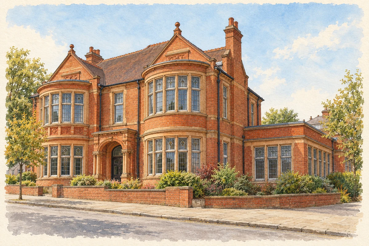
Watercolour and fine ink illustration of Bilston Gallery and Library, former Brueton House
Illustration · Bilston Gallery and Library, former Brueton House
Original illustration; researched sources
Research sources

Original architectural composition based on the cited building descriptions; incidental setting and fine details are interpretive.

Wolverhampton Council local heritage record; Wolverhampton Arts: Bilston Gallery

History & heritage

Place & story

Small metal goods and skilled hands

Bilston’s metalworking history includes objects small enough to hold in a hand. Enamel boxes began with thin copper or copper-alloy sheets pressed into shape, then decorated with coloured glass-based glazes. Box making, preparing enamel, painting and firing required different skills. A University of York study places Bilston among the principal West Midlands centres of this eighteenth-century trade. [3]

An industrial visitor in 1754, Rheinhold Angerstein, recorded women preparing, dipping, painting and firing enamel at a workshop between Bilston and Wolverhampton. He also noted many workshops in Bilston itself. This evidence gives women a place in the manufacturing story and connects apparently delicate luxury goods with organised production and wholesale selling. [3]

Transport, workshops and a crowded town

The council’s conservation appraisal dates the canal’s arrival south of Bilston to 1770. Cheaper movement of coal helped link local production to wider markets. Railways followed in 1854, cutting through the centre and taking part of a churchyard and Pipe Hall’s orchard. Transport changed the shape of the town as well as the movement of its goods. [2]

Industrial growth brought housing along the main streets and in courts behind them. Poor sanitation accompanied this expansion: cholera struck in 1832 and again in 1849. Reverend William Leigh appealed through London newspapers for relief. The burial grounds associated with these epidemics make the human cost of industrial urbanisation visible alongside the surviving commercial streets. [2]

Steel and the battle over closure

Bilston’s steelworks was a workplace around which community identity formed. The local Trades Union Council records the rolling mills closing in 1979, followed by further redundancies. An Action Committee drew the wider town into resistance; hundreds travelled to London and held a vigil outside British Steel’s headquarters. Closure was experienced as a public struggle over the town’s future. [5]

The demolition of the Elisabeth blast furnace on 5 October 1980 removed a familiar landmark. Employment ended in stages rather than on one simple closing day: the union’s longer history records the last 450 men leaving in July 1981. A volunteer oral-history project begun in 2015 returned to those memories, collecting accounts from former steelworkers and campaigners. [5] [6]

A lockmaker’s house becomes a public resource

Frederick Harper built his family house in 1905 on the site of Brueton House in Mount Pleasant. Both the Harper and Brueton families were local lockmakers. Now shared by Bilston Gallery and the library, the building links manufacturing prosperity with public access to culture and learning. Its exhibition interprets Bilston and the wider Black Country’s industrial history. [4]

Back to contents
Lives connected to this place

Notable people

William Leigh: appealing for a stricken town

Reverend William Leigh’s specific local role was his response to Bilston’s 1832 cholera epidemic. His newspaper appeal carried news of the inhabitants’ suffering beyond the district and sought charitable relief. The council appraisal reproduces a contemporary map made for him, connecting the relief campaign with efforts to record where disease struck. [2]

Dennis Turner: organising resistance

Councillor Dennis Turner was among the leaders of the Action Committee opposing Bilston steelworks closure. The Trades Union Council’s history places him within the campaign’s political and workplace network and records that he became Bilston’s MP in 1987. His connection here is direct participation in the fight to protect local employment. [6]

Back to contents
A chronology

Timeline

Bilston through time

  1. 1754 — Angerstein records enamel manufacture near Bilston and numerous workshops in the town. [3]

  2. 1770 — The canal reaches the area south of Bilston. [2]

  3. 1832 and 1849 — Cholera epidemics strike the industrial town. [2]

  4. 1854 — Two railway routes open through Bilston. [2]

  5. 1905 — Frederick Harper’s house is built on the Brueton House site. [4]

  6. 1979 — The steelworks rolling mills close amid a community campaign. [5]

  7. 5 October 1980 — The Elisabeth furnace is demolished. [5]

  8. July 1981 — The union history records the final 450 workers leaving. [6]

  9. 2015 — Volunteers begin collecting steelworks oral histories. [5]

Back to contents

Population over time

Built-up area · Settlement · Census 2021

Bilston (Wolverhampton)

34,640people · 2021

Census 2021 population of the named settlement, using ONS built-up area boundaries.

Published census counts.

Sources: ONS: Towns and cities, characteristics of built-up areas, Census 2021 (Table 1c)

View population figures
Bilston (Wolverhampton) — census population
Census yearPopulation
202134,640
Sources and how to read this chart

Usual residents on 21 March 2021; published ONS count rounded to the nearest 5.. Boundary geography: December 2022 (E63002772).

Census 2021 population of the named settlement, using ONS built-up area boundaries.

ONS Table 1c rounds counts to the nearest 5 and suppresses counts below 10. Matched by exact settlement name or individually reviewed district-qualified name, with its coordinate strictly inside that same official BUA boundary. The 2022 BUA geography changed methodology and cannot be directly compared with 2011 BUAs. Contains OS data © Crown copyright and database right 2026. Contains National Statistics data © Crown copyright and database right 2026.

Source: ONS: Towns and cities, characteristics of built-up areas, Census 2021 (Table 1c). Open Government Licence v3.0. Retrieved 2026-10-26. Source: ONS and Ordnance Survey: Built Up Areas December 2022 GB BGG. Open Government Licence v3.0. Retrieved 2026-10-26.

Neighbourhood census context

These figures describe statistical neighbourhoods, which may cover part of a place or include neighbouring places.

Neighbourhood census area · 1971–2021

Wolverhampton 029

Population of the area containing the recorded point for Bilston, not the whole place. This area may cover part of the place or include neighbours.

05k10k15k20k1971: 9,794 people19711981: 8,667 people19811991: 7,972 people19912001: 7,815 people20012011: 9,054 people20112021: 11,505 people2021

Includes harmonised historical census estimates.

Sources: ONS · Paul Norman

View population figures
Wolverhampton 029 — census population and harmonised historical estimates
Census yearPopulation
19719,794
19818,667
19917,972
20017,815
20119,054
202111,505
Sources and how to read this chart

Usual residents of the containing MSOA; this is local area context, not the population of the named settlement.. Boundary geography: 1 April 2022 (E02002177).

2011 and 2021 census counts harmonised by ONS to the same 1 April 2022 geography. Location matched to ONS 2021 MSOA polygons (full resolution, coastline clipped, V7). ONS exact-fit lookup marks this MSOA unchanged from 2011 (U); historical estimates use that same footprint.

1971–2011: Paul Norman harmonised historical estimates on 2011 MSOAs, rounded to whole residents (1971–1991 are modelled). 2021: ONS census count. The historical 2011 total can differ slightly from the ONS change-over-time 2011 total because of methodology and statistical disclosure controls. These are area estimates, not settlement totals.

Source: ONS Census change over time: usual resident population, 2011 and 2021. Open Government Licence v3.0. Retrieved 2026-10-26. Source: ONS MSOA December 2021 boundaries EW BFC V7. Open Government Licence v3.0. Retrieved 2026-10-26. Source: Paul Norman — Area characteristics: Great Britain 1971 to 2011. Creative Commons Attribution 4.0. Retrieved 2026-10-26. Source: ONS MSOA 2011 to MSOA 2021 exact-fit lookup for England and Wales. Open Government Licence v3.0. Retrieved 2026-10-26.

Recorded locationBilston52.56428° N · 2.07934° WInteractive map loads when this area enters view.
Approximate recorded location · Geographic source

Geographic context

Place type
Town
Country / region
England · West Midlands
County group
West Midlands
Current administration
City of Wolverhampton
Recorded coordinates
52.56428, -2.07934
OS Open Names ID
osgb4000000074567799

County groups are browsing aids. Current administrative and historic areas are recorded separately.

Recorded names

  • Bilston · en · official

Nearby heritage

Distances are from the recorded place point. Proximity does not establish that a site lies within the place boundary or belongs to its history.

Sources & further reading

  1. OS Open Names October 2026 · Source licence.
  2. Bilston Town Centre Conservation Area Appraisal and Management Proposals · City of Wolverhampton Council
  3. The Fall and Rise of the Patch Box · University of York, Digital Museum of Dress Accessories
  4. Bilston Gallery · Wolverhampton Arts and Culture
  5. Bilston Steelworks · Wolverhampton, Bilston & District Trades Union Council
  6. History of Wolverhampton, Bilston and District Trades Union Council 1865–1990, page 12 · Wolverhampton, Bilston & District Trades Union Council
  7. Original illustration of Bilston Gallery and Library, former Brueton House by PlaceHistory. Researched sources are linked beneath the illustration. Original composition from inspected architectural facts; no source photograph copied or used as an image-edit input. Fine detail is interpretive, not a measured survey.

Geographic source retrieved 2026-10-26. History last researched 2026-10-26. How this page was prepared.