Town

Brierley Hill

Brierley Hill’s churches, canals and public buildings belonged to a community shaped by metalworking and skilled manufacture. The closure of Round Oak brought another profound change to its working landscape.

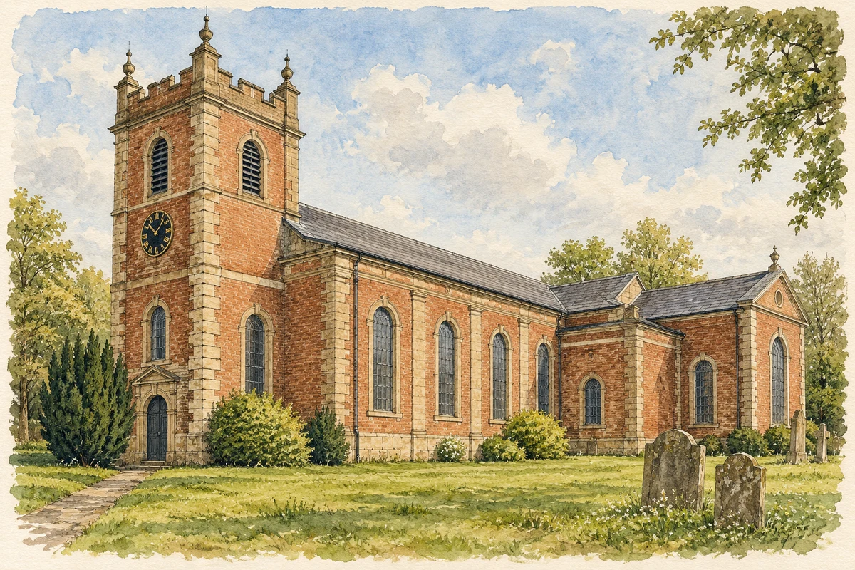
Watercolour and fine ink illustration of St Michael’s Church in Brierley Hill
Original illustration · St Michael’s Church in Brierley Hill
Original illustration; researched sources
Research sources

Original composition informed by the cited historical and architectural records. Fine detail and surrounding planting are simplified; this is an illustration, not a measured record.

Historic England: St Michael’s Church; Dudley Archives: St Michael’s Church

History & heritage

Place & story

A congregation growing with the town

St Michael’s stands above the town in a large churchyard. Built around 1765 by public subscription as a chapel of ease, it soon needed more room. Transepts were added in 1823 and another enlargement followed in 1837. The church’s repeated expansion records the demands of a growing community before the great Round Oak works began. [2]

Further rebuilding in 1900 extended the chancel and strengthened and recased the tower. Despite these changes, the building retained a classical core, with galleries carried on columns and round-headed arches. Its later alterations were not confined to ceremonial space: reordering in 1994 created side rooms and adapted the building for different uses. [2]

Canals and the works

The Delph flight linked the Dudley No. 1 Canal with the Stourbridge Canal. Its original nine locks were constructed in 1777–79; rebuilding in 1858 reduced the number to eight. The enduring name ‘Nine Locks’ preserves an earlier arrangement. The waterway was part of the industrial transport system through which this district exchanged heavy goods. [4] [5]

Round Oak Iron Works opened in 1857 under Richard Smith, the Earl of Dudley’s principal agent. It brought together resources from the estate’s mines, quarries and furnaces, using canal and railway connections to link extraction with manufacture. [3]

Dudley Archives holds the works’ wage books from 1866, recording names and weekly work, alongside departmental accounts, photographs and Pensnett Railway records. These documents reveal a working community as well as a company. [3]

Learning alongside industry

The Technical Institute and Public Library on Moor Street opened in 1904, combining a free library with training for local glass-industry apprentices. Andrew Carnegie contributed £2,000 towards the library, and the urban district council bore the remaining cost. Borough surveyor Lewis Harper designed the building; C. A. Horton built it. [6]

Its decoration gave practical education a public face. Historic England records surviving tiling, stained glass and original planning, including a staircase window representing the Fine Arts. A building intended for apprentices also offered books and reading to the wider community, bringing different kinds of learning together. [6]

Steel gives way to a different economy

As steel replaced wrought iron, Round Oak’s production changed. In 1936 the business adopted the name Round Oak Steel Works Ltd as iron and chain manufacture were discontinued. By 1977 Tube Investments and British Steel Corporation jointly owned it. Industrial continuity therefore concealed substantial changes in products and ownership. [7]

The works closed on 23 December 1982. Dudley Archives records around 1,300 redundancies and the sale of the site in March 1983 to Don and Roy Richardson. The former works became the Waterfront office development; adjoining Merry Hill Farm formed part of the larger redevelopment that included the shopping centre. The distinction between these sites matters when reading the new landscape. [3]

The High Street as a historical record

The High Street retained a separate civic and commercial identity through these changes. The council’s appraisal values the group of surviving shops, public buildings and industrial premises, their details and their relationship with open spaces. Conservation-area designation on 12 March 2009 recognised the town centre as evidence of economic and community development. [8]

More recent heritage work has also recorded living residents. The ‘100 Faces of Brierley Hill’ project brought together portraits and film in 2023 for preservation in Dudley Archives. Beside monuments to manufacture, these records keep a place for the people who continued to live in the town after its industrial transformation. [9]

Back to contents
Lives connected to this place

Notable people

Richard Smith: organising Round Oak

Richard Smith directed the building of Round Oak in 1857 as the Earl of Dudley’s principal agent. His managerial role helps explain the organisation behind the works. [3]

Lewis Harper: a building for apprentices and readers

Lewis Harper, borough surveyor to Brierley Hill, designed its Technical Institute and Public Library in 1903–04. His local significance lies in this combined civic and educational commission, whose plan accommodated both the reading public and apprentices in the glass trade. [6]

Back to contents
A chronology

Timeline

Brierley Hill through time

  1. About 1765 — Public subscription funds St Michael’s chapel. [2]

  2. 1777–79 — The original Delph locks are constructed. [4]

  3. 1823 — St Michael’s gains transepts. [2]

  4. 1857 — Round Oak Iron Works begins operation. [3]

  5. 1858 — Eight rebuilt Delph locks replace the original nine. [5]

  6. 1904 — The Technical Institute and Public Library opens. [6]

  7. 1936 — The company becomes Round Oak Steel Works Ltd. [7]

  8. 23 December 1982 — Round Oak closes. [3]

  9. 12 March 2009 — The High Street conservation area is designated. [8]

Back to contents

Population over time

Built-up area · Settlement · Census 2021

Brierley Hill

32,305people · 2021

Census 2021 population of the named settlement, using ONS built-up area boundaries.

Published census counts.

Sources: ONS: Towns and cities, characteristics of built-up areas, Census 2021 (Table 1c)

View population figures
Brierley Hill — census population
Census yearPopulation
202132,305
Sources and how to read this chart

Usual residents on 21 March 2021; published ONS count rounded to the nearest 5.. Boundary geography: December 2022 (E63002913).

Census 2021 population of the named settlement, using ONS built-up area boundaries.

ONS Table 1c rounds counts to the nearest 5 and suppresses counts below 10. Matched by exact settlement name or individually reviewed district-qualified name, with its coordinate strictly inside that same official BUA boundary. The 2022 BUA geography changed methodology and cannot be directly compared with 2011 BUAs. Contains OS data © Crown copyright and database right 2026. Contains National Statistics data © Crown copyright and database right 2026.

Source: ONS: Towns and cities, characteristics of built-up areas, Census 2021 (Table 1c). Open Government Licence v3.0. Retrieved 2026-10-26. Source: ONS and Ordnance Survey: Built Up Areas December 2022 GB BGG. Open Government Licence v3.0. Retrieved 2026-10-26.

Neighbourhood census context

These figures describe statistical neighbourhoods, which may cover part of a place or include neighbouring places.

Neighbourhood census area · 1971–2021

Dudley 025

Population of the area containing the recorded point for Brierley Hill, not the whole place. This area may cover part of the place or include neighbours.

02.3k4.5k6.8k9k1971: 6,938 people19711981: 7,531 people19811991: 7,985 people19912001: 7,554 people20012011: 8,548 people20112021: 8,738 people2021

Includes harmonised historical census estimates.

Sources: ONS · Paul Norman

View population figures
Dudley 025 — census population and harmonised historical estimates
Census yearPopulation
19716,938
19817,531
19917,985
20017,554
20118,548
20218,738
Sources and how to read this chart

Usual residents of the containing MSOA; this is local area context, not the population of the named settlement.. Boundary geography: 1 April 2022 (E02002024).

2011 and 2021 census counts harmonised by ONS to the same 1 April 2022 geography. Location matched to ONS 2021 MSOA polygons (full resolution, coastline clipped, V7). ONS exact-fit lookup marks this MSOA unchanged from 2011 (U); historical estimates use that same footprint.

1971–2011: Paul Norman harmonised historical estimates on 2011 MSOAs, rounded to whole residents (1971–1991 are modelled). 2021: ONS census count. The historical 2011 total can differ slightly from the ONS change-over-time 2011 total because of methodology and statistical disclosure controls. These are area estimates, not settlement totals.

Source: ONS Census change over time: usual resident population, 2011 and 2021. Open Government Licence v3.0. Retrieved 2026-10-26. Source: ONS MSOA December 2021 boundaries EW BFC V7. Open Government Licence v3.0. Retrieved 2026-10-26. Source: Paul Norman — Area characteristics: Great Britain 1971 to 2011. Creative Commons Attribution 4.0. Retrieved 2026-10-26. Source: ONS MSOA 2011 to MSOA 2021 exact-fit lookup for England and Wales. Open Government Licence v3.0. Retrieved 2026-10-26.

Recorded locationBrierley Hill52.47251° N · 2.10454° WInteractive map loads when this area enters view.
Approximate recorded location · Geographic source

Geographic context

Place type
Town
Country / region
England · West Midlands
County group
West Midlands
Current administration
Dudley
Recorded coordinates
52.47251, -2.10454
OS Open Names ID
osgb4000000074566400

County groups are browsing aids. Current administrative and historic areas are recorded separately.

Recorded names

  • Brierley Hill · en · official

Nearby heritage

Distances are from the recorded place point. Proximity does not establish that a site lies within the place boundary or belongs to its history.

Sources & further reading

  1. OS Open Names October 2026 · Source licence.
  2. Church of St Michael: list entry 1227966 · Historic England
  3. Round Oak Steel Works Ltd: archive collection DROU · Dudley Archives
  4. Nine Locks, The Delph: archive record p/2216 · Dudley Archives
  5. Birmingham Canal Navigations: collection BW165 · Canal & River Trust
  6. Technical Institute and Public Library: list entry 1405554 · Historic England
  7. Round Oak donation to Dudley Museum at The Archives · Dudley Council
  8. Brierley Hill High Street Conservation Area · Dudley Council
  9. Brierley Hill High Street Heritage Action Zone · Dudley Council
  10. Original illustration of St Michael’s Church in Brierley Hill by PlaceHistory. Researched sources are linked beneath the illustration. AI-assisted original watercolour and fine ink composition from inspected factual research; no source photograph was supplied as an image-edit input.

Geographic source retrieved 2026-10-26. History last researched 2026-10-27. How this page was prepared.