Coventry’s wealth moved from medieval cloth to ribbons, watches, bicycles and engines. Its surviving guildhall and almshouses, factory history, rebuilt shopping streets and paired cathedrals show how work and civic ambition repeatedly reshaped the city.
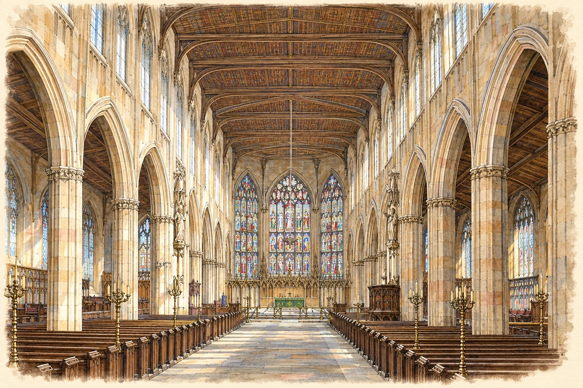
Historical reconstruction · St Michael’s, Coventry, before its destruction · late nineteenth century
Artistic reconstruction · Late nineteenth century
Artistic recreation based on current evidence, following an engraving published in 1891. St Michael’s was then a parish church and later became Coventry’s cathedral.
Evidence and interpreted details
Uncertain details: The engraving was published in 1891, but its precise depicted date is uncertain. Colours, glazing designs, fine ornament and minor furnishings are interpreted from monochrome evidence.
Leofric, Earl of Mercia, and his wife Godiva founded a church dedicated in 1043 in what was then a scattered settlement. Coventry developed into a wealthy city, with wool and cloth connecting the Midlands countryside to urban trade. Religious houses, pilgrimage and royal patronage accompanied that prosperity. Its timber and sandstone buildings were products of an economy reaching far beyond the walls.[5]
St Mary’s Guildhall makes the connection between trade and civic power tangible. The Guild of St Mary first built a hall in the early 1340s. Around 1392, the formation of a combined Holy Trinity Guild brought a major rebuilding campaign: a larger stone hall, kitchen, meeting rooms and entrance structures replaced the earlier building. Commerce required places to assemble, entertain and govern.[6]
The Guildhall also complicates the idea of a medieval city simply erased in 1940. It was damaged: Caesar’s Tower was largely destroyed, and the Great Hall roof and Armoury required repairs. The restored building preserves medieval spaces through substantial later craftsmanship. Survival and reconstruction are intertwined even in some of Coventry’s oldest landmarks.[6]
Charity behind a timber front
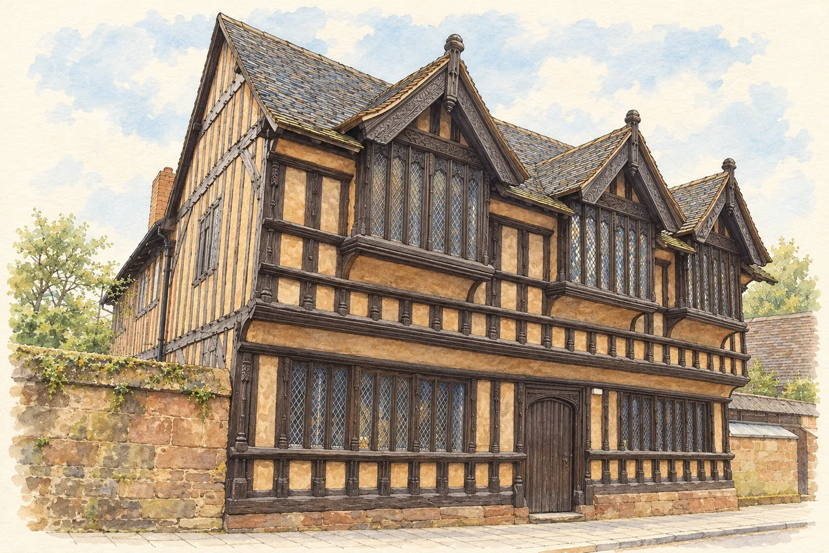
Ford’s Hospital in Greyfriars Lane was an almshouse, providing accommodation rather than the medical treatment now suggested by its name. It originally served men and women, later becoming a women’s home after 1800. Such foundations made support for older residents a lasting part of the city’s built environment, beside the more conspicuous institutions of merchants and government.[8]
William Ford endowed the foundation by will in 1509, with a further endowment by William Pisford in 1517. Historic England explains that the date 1529 on the building relates to trustees’ appointment and possibly further construction. The overhanging upper floor, close-set framing and carved doorways display considerable craftsmanship. After severe wartime damage, the building was reconstructed with original timbers in 1951–53: its old appearance carries a modern history of repair.[7]
Illustration · Ford’s Hospital, Coventry
Ribbons and watches before the motor city
Coventry’s industrial history was repeatedly unsettled. Ribbon weaving became a major occupation, but mechanisation provoked resistance and the crisis around 1860 left families dependent on relief. Watchmaking also faced growing foreign competition. These trades should not be treated as a peaceful prelude to engineering success: changing markets and production methods could threaten household livelihoods long before the twentieth-century factory closures.[5]
New manufacture developed through existing technical skills and equipment. The Coventry Machinists’ Company, originally a sewing-machine business, accepted an order for 400 velocipedes in 1868. Cycle production brought together precision work, components and specialised machinery. By the 1890s this industrial network was well placed to experiment with powered bicycles, motorcycles and cars.[9]
Factories and the working day
Daimler opened its Coventry factory in 1896. Motor firms benefited from the component suppliers and machine-tool businesses developed alongside cycling. The range widened beyond private cars to motorcycles, commercial vehicles, tractors and taxis. Coventry’s motor industry was consequently an interdependent manufacturing district, with many skills and businesses contributing to the finished vehicle.[9]
Large factories changed the organisation of work. By 1939 the main car assemblers and Courtaulds each employed workforces of roughly 5,000, while electrical engineering was another substantial employer. Assembly lines altered occupational status and payment. Historians David Thoms and Tom Donnelly note that bonus earnings could make production work attractive even to skilled men, unsettling a simple division between craft status and better wages.[10]
The scale of employment was accompanied by larger and more specialised firms. Mergers, new production methods and investment in plant brought management structures increasingly distant from the small workshop. The working experience of Coventry’s industrial expansion therefore involved changes in authority, pace and reward as well as the arrival of new machines.[10]
People arriving for work and refuge
Factories drew people from across Britain and Ireland, and in the 1950s and 1960s from the Caribbean and South Asia. The city also received people displaced by political violence, including East African refugees escaping Idi Amin’s Uganda in the 1970s. Coventry’s changing population reflected both the demand for labour and journeys made for safety; these were different experiences within the same city.[11]
Engineering wages and opportunities helped give post-war Coventry a reputation for prosperity. The council’s account describes workers arriving from across the British Isles and overseas to share in that economy. The later contraction mattered beyond individual firms: an industrial city built around expectations of work had to absorb a sharp reversal in those expectations.[3]
Wartime destruction and a new city centre
St Michael’s had been a parish church for centuries before becoming a cathedral in 1918. On 14 November 1940 it burned during the bombing of Coventry, leaving its tower, spire and open shell. The cathedral’s loss became an internationally recognised image of a raid that destroyed homes and workplaces across the city. The ruin belongs to that wider civilian experience.[2]
Plans for change had already begun before the raid. Donald Gibson, appointed city architect in 1938, faced a centre whose inherited streets could no longer comfortably serve the expanding city. His aim was to separate pedestrians from motor traffic. Bomb damage made comprehensive reconstruction possible, but the planning ideas did not originate with the destruction.[13]
The new precinct replaced the route of Smithford Street with a shopping environment whose service vehicles approached from the rear. Its principal axis aligned with St Michael’s surviving spire, giving the old landmark a deliberate place within the new geometry. This was a reorganisation of movement and views, rather than just the replacement of individual bombed shops.[12]
The cathedral as a continuing project
Basil Spence’s design won the cathedral competition in 1951. The new building was consecrated in 1962, beside the retained medieval ruins. The two parts belong to one cathedral: the relationship between damaged walls and active worship gives architectural form to remembrance and renewal. Coventry’s cathedral work became closely associated with international reconciliation.[14][4]
The reconstructed centre has itself become an inheritance requiring care. Later renewal of Upper Precinct placed the Naiad sculpture at its fountain, while recovered pieces of Smithford Street recalled what lay beneath. A twentieth-century plan now sits alongside medieval fabric as something the city must interpret and adapt.[12]
Industrial crisis and a musical response
The economic downturn of the 1970s exposed Coventry’s dependence on engineering. The collapse of machine-tool manufacturer Alfred Herbert at the beginning of the 1980s became a particularly visible sign of the crisis. The council connects factory closures and unemployment with the bleak city atmosphere expressed by The Specials’ Ghost Town. Prosperity and recession left cultural as well as physical traces.[3]
2 Tone emerged from Coventry in the late 1970s, drawing together ska, reggae and punk. The Specials and The Selecter carried social criticism into popular music; Jerry Dammers’ record label gave the movement a recognisable visual identity. Its black-and-white checkerboard stood for racial unity. This was a response made through performance and design to the tensions of a changing Britain.[15]
George Eliot: education and intellectual friendship
Mary Ann Evans, later George Eliot, attended the Misses Franklin’s school in Coventry from 1832. Later she lived with her father at Bird Grove in Foleshill, then a village outside the city. Her friendships with ribbon manufacturers Charles Bray and Joseph Cash brought her into the Rosehill Circle, where radical religious discussion helped her reconsider the beliefs of her youth.[16]
John Kemp Starley: designing the safety bicycle
London-born John Kemp Starley joined the family cycle business in Coventry before establishing Starley and Sutton. His Rover safety bicycle of 1885 helped establish the familiar form of the modern bicycle. His association is with invention and manufacture in the city; early Starley machines preserved at Coventry Transport Museum provide a material link to that work.[17]
Ira Aldridge: an actor managing Coventry’s theatre
Ira Aldridge, born in New York, became manager of Coventry Theatre in 1828 while still under 21. His local role forms part of a wider career as a Shakespearean actor and opponent of slavery. Coventry’s 2021 City of Culture programme commissioned a mural honouring that connection, bringing an earlier chapter of Black theatrical leadership into the modern cityscape.[18]
Donald Gibson: planning for the pedestrian
Gibson became Coventry’s first city architect in 1938, aged 29. He argued for shopping spaces where people could move freely without mixing with through traffic. His work shaped the post-war reconstruction, although he left in 1955 before his whole vision was completed. His local legacy is a plan for everyday movement as well as a group of modern buildings.[13]
Jerry Dammers: music and an image of unity
Dammers was central to the 2 Tone sound and ran its record label. His 1979 designs, now documented through V&A collections, developed Walt Jabsco from an image of Jamaican musician Peter Tosh. The checkerboard and figure connected music with a public statement about racial unity. His Coventry relationship is the making of that movement, rather than simply a birthplace claim.[15]
Coventry 031 — census population and harmonised historical estimates
Census year
Population
1971
7,024
1981
6,597
1991
6,338
2001
6,294
2011
8,775
2021
11,152
Sources and how to read this chart
Usual residents of the containing MSOA; this is local area context, not the population of the named settlement.. Boundary geography: 1 April 2022 (E02001988).
2011 and 2021 census counts harmonised by ONS to the same 1 April 2022 geography. Location matched to ONS 2021 MSOA polygons (full resolution, coastline clipped, V7). ONS exact-fit lookup marks this MSOA unchanged from 2011 (U); historical estimates use that same footprint.
1971–2011: Paul Norman harmonised historical estimates on 2011 MSOAs, rounded to whole residents (1971–1991 are modelled). 2021: ONS census count. The historical 2011 total can differ slightly from the ONS change-over-time 2011 total because of methodology and statistical disclosure controls. These are area estimates, not settlement totals.
Illustration of St Michael’s, Coventry, before its destruction, adapted from Coventry-cathedral-interior.jpg by Anonymous engraver; published by Cassell & Co.. Public domain. AI-assisted historical reconstruction; intact fabric restored, colour and lighting added, missing finishes and furnishings interpreted.
Illustration of Ford's Hospital, Coventry, adapted from Ford’s Hospital, Greyfriars Lane, Coventry, 6 April 2014 by Elliott Brown. CC BY-SA 2.0. AI-assisted watercolour and fine ink adaptation of the restored building; fine carving, window panes and planting simplified; small plaques omitted. Adaptation shared under CC BY-SA 2.0.
 place