Village

Meriden

Meriden’s hilltop church, roadside green and former motorcycle works reveal different stages in the life of a village between Birmingham and Coventry.

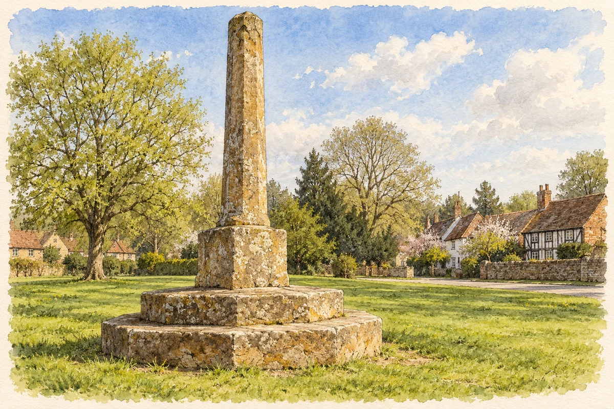
Watercolour and fine ink illustration of The medieval Village Cross, Meriden
Illustration · The medieval Village Cross, Meriden
Original illustration; researched sources
Research sources

Original architectural composition based on the cited building descriptions; incidental setting and fine details are interpretive.

Historic England: Village Cross; Solihull heritage impact assessment

History & heritage

Place & story

From Alspath to the coaching road

Alspath occupied the hill east of Meriden. The London Road drew activity into the valley, where coaching inns served passing traffic. It was turnpiked in 1821. A bypass opened in 1958, reducing through traffic in the village. The contrast between hill and roadside still helps explain the settlement’s shape. [2]

The parish church remained on the hill while the village’s centre shifted. Its surviving stone fabric begins in the twelfth century, with enlargement and alteration between the thirteenth and fifteenth centuries. Nave, aisles, chancel and western tower preserve the outline of a medieval parish church, subsequently restored in the nineteenth century. A later hipped roof replaced the tower’s spire. The building records continuity of worship alongside repeated physical change. [3]

A green with more than one meaning

The medieval cross on the green has three worn stone steps supporting a base that changes from a square to an octagon beneath a tapering shaft. Historic England carefully describes it as popularly said to mark England’s centre. The claim belongs to Meriden’s traditions; it should not be read as a modern geographical measurement. The monument’s age and physical presence are firmer evidence than the precision of that familiar title. [4]

Nearby, the National Cyclists’ Memorial brought another community to the village. Cyclists across the country contributed to its cost, and Lord Birkenhead unveiled it on 21 May 1921. The choice of Meriden was intended to give riders a broadly accessible national meeting place. The memorial commemorates cyclists who died in the First World War, rather than only members of the Army Cyclist Corps. [5]

Its granite obelisk rises from a pedestal with an inscription panel. A bronze plaque added in 1963 extended remembrance to cyclists killed in the Second World War. The May gatherings gave the green a recurring national use: a roadside village became a destination for collective remembrance as well as a place through which travellers passed. [6] [5]

Motorcycles arrive during war

Triumph’s own chronology dates the start of production at its new Meriden factory to 1942. The move brought large-scale motorcycle manufacture into a village district whose older identity rested on agriculture and the road. The company’s history places it within wartime production, followed by the post-war manufacture of models such as the Speed Twin and Tiger 100. Meriden became associated with machines sold far beyond the surrounding Midlands. [7]

Closure resisted, ownership changed

In October 1973, a parliamentary debate described the new Norton Villiers Triumph board’s decision to close Meriden and concentrate manufacture at Small Heath and Wolverhampton. The minister acknowledged workers’ strong reaction after the earlier merger had appeared to promise security. His statement is evidence of the dispute’s immediate political setting: a proposed industrial reorganisation threatened the livelihoods built around one factory. [8]

A workers’ sit-in beginning in 1973 lasted until March 1975, when a co-operative was established to make Bonneville motorcycles, chiefly for the American market. It kept production alive for several more years. Closure followed in 1983, and the site was cleared for housing in 1984. Worker ownership and subsequent residential redevelopment form distinct chapters of the same place. [2]

Back to contents
Lives connected to this place

Notable people

Godiva: a recorded landholder

Countess Godiva held Alspath before the Norman Conquest. By the Domesday survey of 1086 it was held by Nicholas. Her connection to Meriden is therefore one of landholding in its earlier hilltop settlement; the record does not establish a birthplace or a continuous residence here. [2]

Back to contents
A chronology

Timeline

Meriden through time

  1. Twelfth century — The surviving parish church has its origins in this period. [3]

  2. 1821 — The London Road is turnpiked. [2]

  3. 21 May 1921 — The National Cyclists’ Memorial is unveiled. [5]

  4. 1942 — Production begins at Triumph’s new Meriden factory. [7]

  5. 1958 — The bypass opens. [2]

  6. 1963 — A Second World War plaque is added to the cyclists’ memorial. [6]

  7. 1975 — The Meriden Workers’ Co-operative is formed. [7]

  8. 1983–84 — The factory closes and its site is cleared for housing. [2]

Back to contents

Population over time

Built-up area · Settlement · Census 2021

Meriden

2,205people · 2021

Census 2021 population of the named settlement, using ONS built-up area boundaries.

Published census counts.

Sources: ONS: Towns and cities, characteristics of built-up areas, Census 2021 (Table 1c)

View population figures
Meriden — census population
Census yearPopulation
20212,205
Sources and how to read this chart

Usual residents on 21 March 2021; published ONS count rounded to the nearest 5.. Boundary geography: December 2022 (E63002968).

Census 2021 population of the named settlement, using ONS built-up area boundaries.

ONS Table 1c rounds counts to the nearest 5 and suppresses counts below 10. Matched by exact settlement name or individually reviewed district-qualified name, with its coordinate strictly inside that same official BUA boundary. The 2022 BUA geography changed methodology and cannot be directly compared with 2011 BUAs. Contains OS data © Crown copyright and database right 2026. Contains National Statistics data © Crown copyright and database right 2026.

Source: ONS: Towns and cities, characteristics of built-up areas, Census 2021 (Table 1c). Open Government Licence v3.0. Retrieved 2026-10-26. Source: ONS and Ordnance Survey: Built Up Areas December 2022 GB BGG. Open Government Licence v3.0. Retrieved 2026-10-26.

Neighbourhood census context

These figures describe statistical neighbourhoods, which may cover part of a place or include neighbouring places.

Neighbourhood census area · 1971–2021

Solihull 017

Population of the area containing the recorded point for Meriden, not the whole place. This area may cover part of the place or include neighbours.

02k4k6k8k1971: 4,975 people19711981: 5,583 people19811991: 6,145 people19912001: 6,454 people20012011: 6,550 people20112021: 7,345 people2021

Includes harmonised historical census estimates.

Sources: ONS · Paul Norman

View population figures
Solihull 017 — census population and harmonised historical estimates
Census yearPopulation
19714,975
19815,583
19916,145
20016,454
20116,550
20217,345
Sources and how to read this chart

Usual residents of the containing MSOA; this is local area context, not the population of the named settlement.. Boundary geography: 1 April 2022 (E02002097).

2011 and 2021 census counts harmonised by ONS to the same 1 April 2022 geography. Location matched to ONS 2021 MSOA polygons (full resolution, coastline clipped, V7). ONS exact-fit lookup marks this MSOA unchanged from 2011 (U); historical estimates use that same footprint.

1971–2011: Paul Norman harmonised historical estimates on 2011 MSOAs, rounded to whole residents (1971–1991 are modelled). 2021: ONS census count. The historical 2011 total can differ slightly from the ONS change-over-time 2011 total because of methodology and statistical disclosure controls. These are area estimates, not settlement totals.

Source: ONS Census change over time: usual resident population, 2011 and 2021. Open Government Licence v3.0. Retrieved 2026-10-26. Source: ONS MSOA December 2021 boundaries EW BFC V7. Open Government Licence v3.0. Retrieved 2026-10-26. Source: Paul Norman — Area characteristics: Great Britain 1971 to 2011. Creative Commons Attribution 4.0. Retrieved 2026-10-26. Source: ONS MSOA 2011 to MSOA 2021 exact-fit lookup for England and Wales. Open Government Licence v3.0. Retrieved 2026-10-26.

Recorded locationMeriden52.43637° N · 1.64641° WInteractive map loads when this area enters view.
Approximate recorded location · Geographic source

Geographic context

Place type
Village
Country / region
England · West Midlands
County group
West Midlands
Current administration
Solihull
Recorded coordinates
52.43637, -1.64641
OS Open Names ID
osgb4000000074572814

County groups are browsing aids. Current administrative and historic areas are recorded separately.

Recorded names

  • Meriden · en · official

Nearby heritage

Distances are from the recorded place point. Proximity does not establish that a site lies within the place boundary or belongs to its history.

Sources & further reading

  1. OS Open Names October 2026 · Source licence.
  2. Meriden history · Solihull Metropolitan Borough Council
  3. Church of St Lawrence, list entry1031828 · Historic England
  4. Village Cross, list entry1076746 · Historic England
  5. Meriden’s Cycling Memorial · Our Warwickshire / Warwickshire heritage partnership
  6. Cyclists War Memorial, list entry1389323 · Historic England
  7. Factory visitor experience: company chronology · Triumph Motorcycles
  8. BSA Triumph Motor Cycles Limited,5 October1973 · UK Parliament / Hansard
  9. Original illustration of The medieval Village Cross, Meriden by PlaceHistory. Researched sources are linked beneath the illustration. Original composition from inspected architectural facts; no source photograph copied or used as an image-edit input. Fine detail is interpretive, not a measured survey.

Geographic source retrieved 2026-10-26. History last researched 2026-10-27. How this page was prepared.