Town

Oldbury

Canals helped turn Oldbury into a compact industrial town. Its chemical works, courthouse, churches and public park reveal how manufacturing growth went alongside new institutions and demands for shared space.

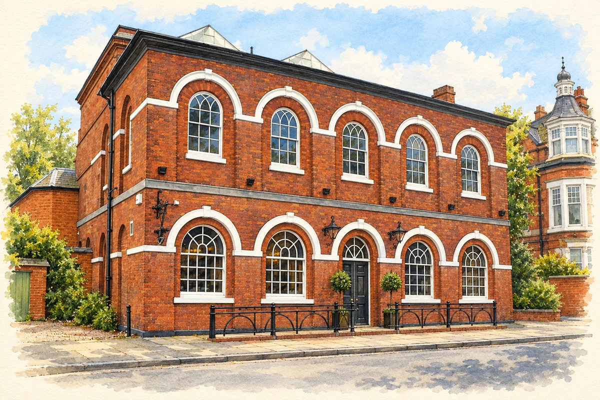
Watercolour and fine ink illustration of Oldbury's former Court of Requests
Illustration · Oldbury's former Court of Requests
History & heritage

Place & story

A canal town takes shape

Oldbury’s industrial growth was closely tied to transport. Brindley’s canal, completed in 1769, looped around the north of the settlement; Telford’s improvements in the 1820s made the town centre a canal island. Works beside the water drew businesses and workers, while new streets extended from the older marketplace. [2]

The town’s administrative identity also changed. Sandwell’s archives preserve records of Oldbury Urban District Council from 1894 to 1935 and the Municipal Borough from 1935 to 1966, followed by Warley County Borough until 1974. These are successive authorities, not different names for an unchanged area. The present profile concerns Oldbury in the West Midlands, within Sandwell. [3]

Chemistry alongside glass and iron

In 1835 Chance Brothers bought nine acres in Oldbury for a factory making saltcake for glass manufacture. The site lay between Park House Lane and an arm of the Birmingham Canal. Its product helped neighbouring glassmaking by supplying a chemical ingredient used in melting and refining the glass mixture: Oldbury’s factories belonged to an interconnected manufacturing district. [4]

Albright and Wilson became another major chemical enterprise based in Oldbury. The Science Museum Group dates the firm from 1856 and records its incorporation as a limited company in 1892. Its subsequent corporate history included purchase by Tenneco in 1978 and acquisition by Rhodia in 1999. The continuity of a works and workforce must therefore be distinguished from continuity of ownership. [5]

Court, congregation and a changing centre

The courthouse at 19 Church Street dates to 1816. Sandwell’s 2008 appraisal describes its later use as a public library and identifies a five-bay brick frontage with arched recesses and a plaque recording the construction date. The building preserves civic history through both its architectural display and its changing purpose. [2]

The local history societies’ account traces the court’s origins to a Court of Requests and records a prison with separate accommodation for men and women. Its discussion of the 1841 census finds coal miners, brickmakers, nailmakers and other working people among the prisoners. Justice and debt were experienced within the same labouring society that supplied Oldbury’s industries. [6]

Christ Church was consecrated in July 1841. The Church of England’s architectural record describes brick with stone dressings, lancet windows and a tower rising above the body of the church. A later parish profile records refurbishment in 1992: the western part became offices producing diocesan rental income, while the eastern part continued as a modernised worship space. The building’s adaptation was itself a response to sustaining a large inherited church. [7] [8]

An industrial family’s park

Barnford Hill Park connects industrial wealth with public recreation. In evidence submitted to a parliamentary inquiry, the Friends of Barnford Park recorded that W. A. Albright gave the land to Oldbury in 1915; the park opened in 1916 after preparation of the former arable ground. Its sporting and social facilities included bowls, tennis, football, cricket and a Sons of Rest. [9]

The same submission described the loss or deterioration of facilities by the late 1990s and the formation of a user group in 1994. The subsequent Friends organisation sought improvements for Oldbury, Langley and neighbouring residents. This is evidence of a particular period of campaigning, not a description of the park’s present condition. It shows how an inherited gift could require renewed public organisation. [9]

Back to contents
Lives connected to this place

Notable people

Arthur Albright: business rooted here, a home elsewhere

Arthur Albright’s connection to Oldbury was industrial. Birmingham’s archive catalogue describes his move into phosphorus production and the establishment of a works here in 1851. His family lived in Edgbaston, and surviving letters document business travel as well as a Quaker household. He should therefore be identified as an industrialist working through Oldbury, rather than assumed to have been born or resident in the town. [10]

Jack Judge: work, song and the local stage

John Thomas ‘Jack’ Judge was born in Oldbury in 1872. Before his national reputation as a music-hall performer and songwriter, he worked at an iron foundry and in his family’s fish trade. Local halls and talent competitions helped develop his performing skills. His life connects entertainment with the working households and small businesses of the industrial town. [11]

Judge became associated internationally with ‘It’s a Long Way to Tipperary’, popular with soldiers during the First World War. The local history societies’ detailed account cautions that competing stories surround its origins. His Oldbury birth, work and early performance career are firmer local connections than a claim that the finished song can be placed unambiguously at one Oldbury address. [11]

Back to contents
A chronology

Timeline

Oldbury through time

  1. 1769 — Brindley’s canal through Oldbury is completed. [2]

  2. 1816 — The Church Street courthouse is built. [2]

  3. 1835 — Chance Brothers buy an Oldbury site for chemical manufacture. [4]

  4. 1841 — Christ Church is consecrated. [7]

  5. 1851 — Arthur Albright establishes a phosphorus works in Oldbury. [10]

  6. 1872 — Jack Judge is born in Oldbury. [11]

  7. 1915–16 — Land given by W. A. Albright becomes Barnford Hill Park. [9]

  8. 1935 — Oldbury becomes a municipal borough. [3]

  9. 1966–74 — Oldbury forms part of Warley County Borough before the creation of Sandwell. [3] [9]

Back to contents

Population over time

Built-up area · Settlement · Census 2021

Oldbury (Sandwell)

45,180people · 2021

Census 2021 population of the named settlement, using ONS built-up area boundaries.

Published census counts.

Sources: ONS: Towns and cities, characteristics of built-up areas, Census 2021 (Table 1c)

View population figures
Oldbury (Sandwell) — census population
Census yearPopulation
202145,180
Sources and how to read this chart

Usual residents on 21 March 2021; published ONS count rounded to the nearest 5.. Boundary geography: December 2022 (E63002880).

Census 2021 population of the named settlement, using ONS built-up area boundaries.

ONS Table 1c rounds counts to the nearest 5 and suppresses counts below 10. Matched by exact settlement name or individually reviewed district-qualified name, with its coordinate strictly inside that same official BUA boundary. The 2022 BUA geography changed methodology and cannot be directly compared with 2011 BUAs. Contains OS data © Crown copyright and database right 2026. Contains National Statistics data © Crown copyright and database right 2026.

Source: ONS: Towns and cities, characteristics of built-up areas, Census 2021 (Table 1c). Open Government Licence v3.0. Retrieved 2026-10-26. Source: ONS and Ordnance Survey: Built Up Areas December 2022 GB BGG. Open Government Licence v3.0. Retrieved 2026-10-26.

Neighbourhood census context

These figures describe statistical neighbourhoods, which may cover part of a place or include neighbouring places.

Neighbourhood census area · 1971–2021

Sandwell 024

Population of the area containing the recorded point for Oldbury, not the whole place. This area may cover part of the place or include neighbours.

02.3k4.5k6.8k9k1971: 7,820 people19711981: 7,014 people19811991: 6,659 people19912001: 6,408 people20012011: 7,259 people20112021: 8,258 people2021

Includes harmonised historical census estimates.

Sources: ONS · Paul Norman

View population figures
Sandwell 024 — census population and harmonised historical estimates
Census yearPopulation
19717,820
19817,014
19916,659
20016,408
20117,259
20218,258
Sources and how to read this chart

Usual residents of the containing MSOA; this is local area context, not the population of the named settlement.. Boundary geography: 1 April 2022 (E02002066).

2011 and 2021 census counts harmonised by ONS to the same 1 April 2022 geography. Location matched to ONS 2021 MSOA polygons (full resolution, coastline clipped, V7). ONS exact-fit lookup marks this MSOA unchanged from 2011 (U); historical estimates use that same footprint.

1971–2011: Paul Norman harmonised historical estimates on 2011 MSOAs, rounded to whole residents (1971–1991 are modelled). 2021: ONS census count. The historical 2011 total can differ slightly from the ONS change-over-time 2011 total because of methodology and statistical disclosure controls. These are area estimates, not settlement totals.

Source: ONS Census change over time: usual resident population, 2011 and 2021. Open Government Licence v3.0. Retrieved 2026-10-26. Source: ONS MSOA December 2021 boundaries EW BFC V7. Open Government Licence v3.0. Retrieved 2026-10-26. Source: Paul Norman — Area characteristics: Great Britain 1971 to 2011. Creative Commons Attribution 4.0. Retrieved 2026-10-26. Source: ONS MSOA 2011 to MSOA 2021 exact-fit lookup for England and Wales. Open Government Licence v3.0. Retrieved 2026-10-26.

Recorded locationOldbury52.50509° N · 2.01593° WInteractive map loads when this area enters view.
Approximate recorded location · Geographic source

Geographic context

Place type
Town
Country / region
England · West Midlands
County group
West Midlands
Current administration
Sandwell
Recorded coordinates
52.50509, -2.01593
OS Open Names ID
osgb4000000074566095

County groups are browsing aids. Current administrative and historic areas are recorded separately.

Recorded names

  • Oldbury · en · official

Nearby heritage

Distances are from the recorded place point. Proximity does not establish that a site lies within the place boundary or belongs to its history.

Sources & further reading

  1. OS Open Names October 2026 · Source licence.
  2. Church Square, Oldbury Conservation Area Appraisal and Boundary Review, 2008 · Birmingham Archaeology Heritage Services / Sandwell Council
  3. Our collections: borough records · Sandwell Council
  4. Chance and Hunt · Made in Oldbury / Langley Local History Society
  5. Albright and Wilson Limited, 1856–1999 · Science Museum Group
  6. Oldbury Courthouse and Prison · Oldbury, Langley and Warley local history societies
  7. Oldbury: Christ Church, Church Heritage Record 602080 · Church of England
  8. United Benefice of Oldbury, Langley and Londonderry: parish profile · United Benefice of Oldbury, Langley and Londonderry
  9. Memorandum by The Friends of Barnford Park, TCP 02 · Friends of Barnford Park / House of Commons
  10. Albright family papers, MS 1509 · Library of Birmingham
  11. Jack Judge: His Life and Music, Part 1 · Oldbury, Langley and Warley local history societies
  12. Illustration of Oldbury's former Court of Requests, adapted from Grade II listed The Court of Requests,... by Jaggery. CC BY-SA 2.0. AI-assisted watercolour and fine ink adaptation; incidental clutter simplified, warm cream paper margins. Architectural forms follow the inspected reference.

Geographic source retrieved 2026-10-26. History last researched 2026-10-27. How this page was prepared.