Town

Sedgley

Sedgley's church served an extensive parish, while nail merchants and quarry workers connected the hilltop settlement to a much wider working landscape.

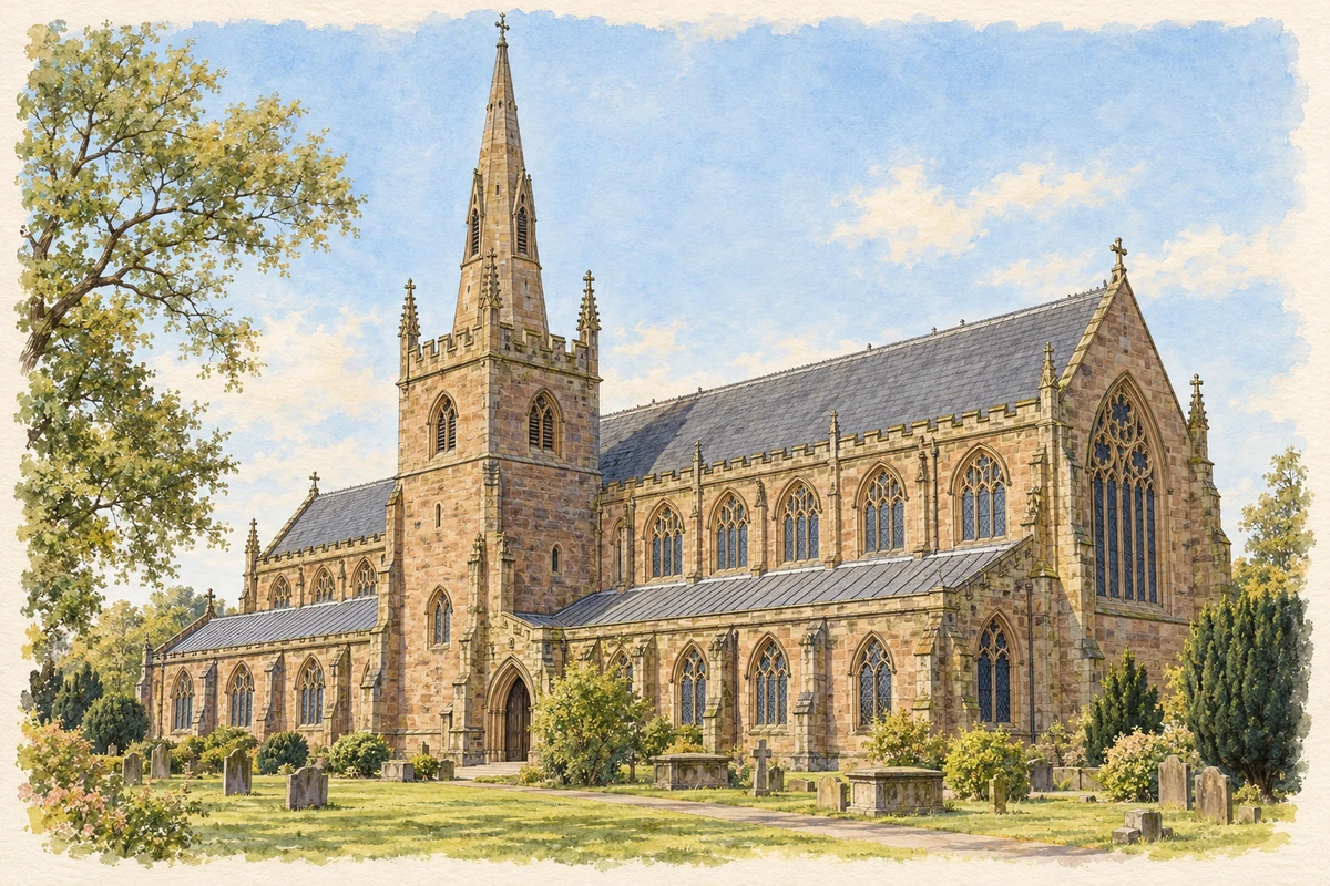
Watercolour and fine ink illustration of All Saints’ Church, Sedgley
Illustration · All Saints’ Church, Sedgley
Original illustration; researched sources
Research sources

Original architectural composition based on the cited building descriptions; incidental setting and fine details are interpretive.

Historic England: All Saints, Sedgley; All Saints’ parish history

History & heritage

Place & story

The parish behind the town

Sedgley once included Coseley, Gornal and Ettingshall in its manor and parish. Dudley Priory founded the church and appointed its vicars; the medieval core of All Saints tower survives from that older religious geography. [2]

Thomas Lee rebuilt the church in 1826–29 with funding from the Earl of Dudley. Restoration in 1882 removed its galleries. Registers, school and charity records, accounts and property papers preserve how the parish organised worship, education and assistance. [2]

Nails as a commercial system

Coal mining and nailmaking employed many people across the Sedgley district during the eighteenth and nineteenth centuries. Nailmasters such as the Wilkes family organised the trade. Their warehouses connected producers with customers: iron rod went out to nailmakers and returned as finished nails, counted or weighed according to size. Making a nail was one stage in a system of supply, credit and distribution. [5]

The local history account draws on Elwell and Willetts papers dated 1824–44, alongside the Brick Street warehouse. It records carriers taking goods towards canal and river ports, and agents gathering orders from ironmongers. This evidence shows how a hilltop community participated in distant markets, although the author's suggested parallels between different nailmasters should not be mistaken for surviving Wilkes business records. [5]

Brick Street's former nail warehouse gives that trade a physical presence. Historic England dates the two-storey Ruiton-stone building only as probably early nineteenth century. Rounded window heads and cast-iron glazing bars remain distinguishing features. Its listing also records later metalworking use: the building's working life extended beyond the trade named on the entry. [6]

A quarried hill becomes shared space

North of the centre, Beacon Hill was quarried intensively from the seventeenth century until around the First World War. Excavation left steep ridges and gullies that have since become wildlife habitat. The sheltered quarry supports unusual butterflies and plants; the council identifies it as a Site of Importance for Nature Conservation. Industrial disturbance helped create the terrain now valued as open space. [3]

The sandstone tower on the summit dates from 1846. Its purpose is less secure: the council questions the familiar astronomical-observatory explanation and reports local research suggesting a folly commissioned through quarry owner Mr Petit. The surviving structure is a firmer historical fact than either story. A Friends group formed in 2010, and council improvements in 2026 repaired its setting and reinstated seventeen missing internal steps. [3]

A school, a mission and an endowment

At Gospel End, a building first used as an infants' school around 1870 later became St Barnabas Mission Church. After closure in the early 1980s it was sold in 1987, becoming a private house. The proceeds endowed the Sedgley Educational Trust, supporting education across the older parish area. [2]

Back to contents
Lives connected to this place

Notable people

Abraham Darby I: a connection through Woodsetton

Abraham Darby I was born in 1678 at Wren's Nest, Woodsetton, within the historical parish of Sedgley. This is a parish connection, rather than a claim that his birthplace was the present town centre. His significant coke-smelting work took place at Coalbrookdale in Shropshire in 1709. A Woodsetton memorial unveiled in 2021, supported by community organisations and local manufacturers, commemorates that wider industrial legacy. [7] [4]

Back to contents
A chronology

Timeline

Sedgley through time

  1. 1558 — The surviving All Saints' parish archive begins. [2]

  2. 1826–29 — Thomas Lee rebuilds All Saints', retaining the older tower core. [2]

  3. 1846 — The present Beacon Tower is erected. [3]

  4. 1882 — Restoration removes the church galleries. [2]

  5. 1987 — Sale of the former Gospel End mission building provides an educational endowment. [2]

  6. 2010 — Friends of Sedgley Beacon is formed. [3]

Back to contents

Population over time

Built-up area · Settlement · Census 2021

Sedgley

31,990people · 2021

Census 2021 population of the named settlement, using ONS built-up area boundaries.

Published census counts.

Sources: ONS: Towns and cities, characteristics of built-up areas, Census 2021 (Table 1c)

View population figures
Sedgley — census population
Census yearPopulation
202131,990
Sources and how to read this chart

Usual residents on 21 March 2021; published ONS count rounded to the nearest 5.. Boundary geography: December 2022 (E63002830).

Census 2021 population of the named settlement, using ONS built-up area boundaries.

ONS Table 1c rounds counts to the nearest 5 and suppresses counts below 10. Matched by exact settlement name or individually reviewed district-qualified name, with its coordinate strictly inside that same official BUA boundary. The 2022 BUA geography changed methodology and cannot be directly compared with 2011 BUAs. Contains OS data © Crown copyright and database right 2026. Contains National Statistics data © Crown copyright and database right 2026.

Source: ONS: Towns and cities, characteristics of built-up areas, Census 2021 (Table 1c). Open Government Licence v3.0. Retrieved 2026-10-26. Source: ONS and Ordnance Survey: Built Up Areas December 2022 GB BGG. Open Government Licence v3.0. Retrieved 2026-10-26.

Neighbourhood census context

These figures describe statistical neighbourhoods, which may cover part of a place or include neighbouring places.

Neighbourhood census area · 1971–2021

Dudley 002

Population of the area containing the recorded point for Sedgley, not the whole place. This area may cover part of the place or include neighbours.

01.8k3.5k5.3k7k1971: 5,515 people19711981: 5,660 people19811991: 5,763 people19912001: 6,007 people20012011: 5,938 people20112021: 6,064 people2021

Includes harmonised historical census estimates.

Sources: ONS · Paul Norman

View population figures
Dudley 002 — census population and harmonised historical estimates
Census yearPopulation
19715,515
19815,660
19915,763
20016,007
20115,938
20216,064
Sources and how to read this chart

Usual residents of the containing MSOA; this is local area context, not the population of the named settlement.. Boundary geography: 1 April 2022 (E02002001).

2011 and 2021 census counts harmonised by ONS to the same 1 April 2022 geography. Location matched to ONS 2021 MSOA polygons (full resolution, coastline clipped, V7). ONS exact-fit lookup marks this MSOA unchanged from 2011 (U); historical estimates use that same footprint.

1971–2011: Paul Norman harmonised historical estimates on 2011 MSOAs, rounded to whole residents (1971–1991 are modelled). 2021: ONS census count. The historical 2011 total can differ slightly from the ONS change-over-time 2011 total because of methodology and statistical disclosure controls. These are area estimates, not settlement totals.

Source: ONS Census change over time: usual resident population, 2011 and 2021. Open Government Licence v3.0. Retrieved 2026-10-26. Source: ONS MSOA December 2021 boundaries EW BFC V7. Open Government Licence v3.0. Retrieved 2026-10-26. Source: Paul Norman — Area characteristics: Great Britain 1971 to 2011. Creative Commons Attribution 4.0. Retrieved 2026-10-26. Source: ONS MSOA 2011 to MSOA 2021 exact-fit lookup for England and Wales. Open Government Licence v3.0. Retrieved 2026-10-26.

Recorded locationSedgley52.54127° N · 2.12207° WInteractive map loads when this area enters view.
Approximate recorded location · Geographic source

Geographic context

Place type
Town
Country / region
England · West Midlands
County group
West Midlands
Current administration
Dudley
Recorded coordinates
52.54127, -2.12207
OS Open Names ID
osgb4000000074566153

County groups are browsing aids. Current administrative and historic areas are recorded separately.

Recorded names

  • Sedgley · en · official

Nearby heritage

Distances are from the recorded place point. Proximity does not establish that a site lies within the place boundary or belongs to its history.

Sources & further reading

  1. OS Open Names October 2026 · Source licence.
  2. Parish records of All Saints, Sedgley · Dudley Archives
  3. Beacon Hill and Tower · Dudley Council
  4. Community groups commission Abraham Darby tribute · Dudley Council
  5. Sedgley's Nail Trade · Sedgley Manor local history website
  6. Former Nail Warehouse (1076020) · Historic England
  7. Abraham Darby: Ironbridge and the Sedgley connection · Sedgley Manor local history website
  8. Original illustration of All Saints’ Church, Sedgley by PlaceHistory. Researched sources are linked beneath the illustration. Original composition from inspected architectural facts; no source photograph copied or used as an image-edit input. Fine detail is interpretive, not a measured survey.

Geographic source retrieved 2026-10-26. History last researched 2026-10-27. How this page was prepared.