Town

Evesham

A bend of the Avon contains the remains of a powerful abbey, a battlefield’s memory and a town connected to the fruit and vegetable growing of the surrounding Vale.

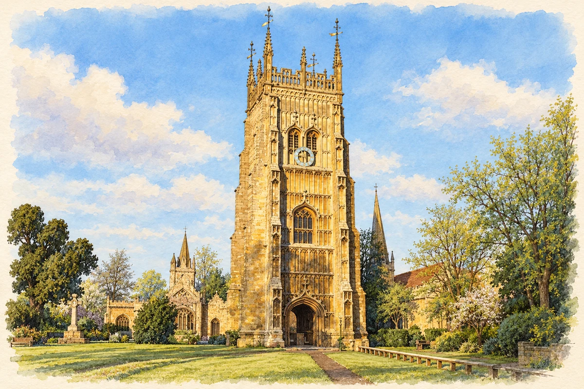
Watercolour and fine ink illustration of Evesham Abbey Bell Tower
Illustration · Evesham Abbey Bell Tower
History & heritage

Place & story

A town inside the river bend

Evesham developed within a loop of the Avon, with the abbey at its heart and open land around it. The Abbey Trust identifies Merstow Green and Vine Street as early centres of a settlement serving the monastery. The relationship between religious precinct, town and river remains legible in the parks and meadows stretching towards Hampton Ferry. [3]

The foundation story joins this landscape to the swineherd Eof, who was said to have seen a vision of the Virgin Mary and reported it to Bishop Ecgwine. This is a religious legend, rather than an eyewitness account of the town’s beginnings. The Trust dates the abbey’s consecration to 709. [3]

War on Green Hill

On 4 August 1265, royal forces led by Prince Edward and the Earl of Gloucester trapped Simon de Montfort’s army at Evesham. De Montfort attempted to break through at Green Hill, but the royal cavalry closed around his flanks. He and his son Henry were killed. The battlefield lies beyond the monastic centre, making the wider landscape essential to understanding the event. [4]

The defeat ended Montfort’s regime, but did not simply erase the reforms associated with it. Parliament’s account explains that Edward continued to summon representatives from shires and boroughs. Evesham’s place in political history therefore rests on a decisive defeat within a longer, uneven development of representative institutions. [5]

Dismantling the abbey

The bell tower records the abbey’s ambition shortly before its destruction. Built by Abbot Lichfield in the early sixteenth century, it rises through three stages, with an archway beneath and open battlements and pinnacles above. Its unfinished vaulting is an unusually immediate trace of building work left incomplete. [2]

By October 1540 demolition of the abbey was already under way. The Abbey Trust cites Philip Hoby’s contemporary complaints about stone already sold and the disorder surrounding its removal. The Crown granted him the monastery site in 1542 while reserving bells and lead. Dissolution changed both ownership and the physical fabric of the town. [6]

An almoner’s house becomes a museum

The Almonry survived the abbey’s destruction. The museum dates it to the fourteenth or early fifteenth century and identifies it as the home of the monk responsible for alms. After closure it became the private residence of the last abbot, Philip Ballard. Its subsequent uses included an alehouse, offices, tea rooms and housing. [7]

Evesham Borough Council bought the building in 1929, and it opened as a museum centre in 1957. A structure once serving a religious household thus became a civic place for collecting and interpreting the town’s past. Its survival complements the tower and fragments of the former precinct. [7] [2]

Growing for wider markets

The town’s agricultural setting supported another economy. The Vale’s alluvial soils and climate favoured fruit and vegetables, including asparagus, plums and apples. Visit Evesham describes generations of market gardeners using hand tools and horse-drawn carts to supply local markets and cities farther away. Seasonal work linked the town to the cultivated countryside around it. [8]

Large-scale market gardening later declined, while food growing businesses continued around Evesham. Tools, memories and local celebrations now preserve part of that working culture. This history belongs to the wider Vale as well as the town; it should not be read as a claim that every crop or garden stood inside Evesham’s streets. [8]

Back to contents
Lives connected to this place

Notable people

Simon de Montfort: a fatal local connection

Simon de Montfort’s connection with Evesham was the battle in which he died, rather than birth or residence in the town. His defeat by the future Edward I on 4 August 1265 ended his control of government. The continuing use of borough and shire representatives gives that local event a significance beyond the battlefield. [5]

Back to contents
A chronology

Timeline

Evesham through time

  1. 709 — The Abbey Trust dates the abbey’s consecration to this year. [3]

  2. 4 August 1265 — Simon de Montfort is defeated and killed at Evesham. [4]

  3. Early sixteenth century — Abbot Lichfield builds the surviving bell tower. [2]

  4. 1540–42 — Demolition begins; the former monastery site is granted to Philip Hoby. [6]

  5. 1929 / 1957 — The council buys the Almonry; it later opens as a museum centre. [7]

Back to contents

Population over time

Built-up area · Settlement · Census 2021

Evesham

28,250people · 2021

Census 2021 population of the named settlement, using ONS built-up area boundaries.

Published census counts.

Sources: ONS: Towns and cities, characteristics of built-up areas, Census 2021 (Table 1c)

View population figures
Evesham — census population
Census yearPopulation
202128,250
Sources and how to read this chart

Usual residents on 21 March 2021; published ONS count rounded to the nearest 5.. Boundary geography: December 2022 (E63003770).

Census 2021 population of the named settlement, using ONS built-up area boundaries.

ONS Table 1c rounds counts to the nearest 5 and suppresses counts below 10. Matched by exact settlement name or individually reviewed district-qualified name, with its coordinate strictly inside that same official BUA boundary. The 2022 BUA geography changed methodology and cannot be directly compared with 2011 BUAs. Contains OS data © Crown copyright and database right 2026. Contains National Statistics data © Crown copyright and database right 2026.

Source: ONS: Towns and cities, characteristics of built-up areas, Census 2021 (Table 1c). Open Government Licence v3.0. Retrieved 2026-10-26. Source: ONS and Ordnance Survey: Built Up Areas December 2022 GB BGG. Open Government Licence v3.0. Retrieved 2026-10-26.

Neighbourhood census context

These figures describe statistical neighbourhoods, which may cover part of a place or include neighbouring places.

Neighbourhood census area · 1971–2021

Wychavon 014

Population of the area containing the recorded point for Evesham, not the whole place. This area may cover part of the place or include neighbours.

01.8k3.5k5.3k7k1971: 4,060 people19711981: 3,790 people19811991: 4,365 people19912001: 5,112 people20012011: 5,890 people20112021: 6,280 people2021

Includes harmonised historical census estimates.

Sources: ONS · Paul Norman

View population figures
Wychavon 014 — census population and harmonised historical estimates
Census yearPopulation
19714,060
19813,790
19914,365
20015,112
20115,890
20216,280
Sources and how to read this chart

Usual residents of the containing MSOA; this is local area context, not the population of the named settlement.. Boundary geography: 1 April 2022 (E02006761).

2011 and 2021 census counts harmonised by ONS to the same 1 April 2022 geography. Location matched to ONS 2021 MSOA polygons (full resolution, coastline clipped, V7). ONS exact-fit lookup marks this MSOA unchanged from 2011 (U); historical estimates use that same footprint.

1971–2011: Paul Norman harmonised historical estimates on 2011 MSOAs, rounded to whole residents (1971–1991 are modelled). 2021: ONS census count. The historical 2011 total can differ slightly from the ONS change-over-time 2011 total because of methodology and statistical disclosure controls. These are area estimates, not settlement totals.

Source: ONS Census change over time: usual resident population, 2011 and 2021. Open Government Licence v3.0. Retrieved 2026-10-26. Source: ONS MSOA December 2021 boundaries EW BFC V7. Open Government Licence v3.0. Retrieved 2026-10-26. Source: Paul Norman — Area characteristics: Great Britain 1971 to 2011. Creative Commons Attribution 4.0. Retrieved 2026-10-26. Source: ONS MSOA 2011 to MSOA 2021 exact-fit lookup for England and Wales. Open Government Licence v3.0. Retrieved 2026-10-26.

Recorded locationEvesham52.09262° N · 1.94742° WInteractive map loads when this area enters view.
Approximate recorded location · Geographic source

Geographic context

Place type
Town
Country / region
England · West Midlands
County group
Worcestershire
Current administration
Wychavon
Current administration
Worcestershire
Recorded coordinates
52.09262, -1.94742
OS Open Names ID
osgb4000000074565636

County groups are browsing aids. Current administrative and historic areas are recorded separately.

Recorded names

  • Evesham · en · official

Nearby heritage

Explore recorded heritage in Evesham and the surrounding area. This selection is based on proximity to a recorded settlement point; it is not a complete inventory or evidence that a site lies within the settlement or belongs to its history.

Heritage locationsEvesham & surrounding areaInteractive map loads when this area enters view. Source records are listed below.

Numbered markers match the source records below. Locations are recorded reference points, not site boundaries.

  1. KING CHARLES II INN · Listed building
  2. 3 AND 5, HIGH STREET · Listed building
  3. TOWN HALL · Listed building
  4. ROUND HOUSE (NATIONAL WESTMINSTER BANK) · Listed building
  5. 2, VINE STREET · Listed building
  6. 7 AND 9, HIGH STREET · Listed building
  7. 12, HIGH STREET · Listed building
  8. 3, VINE STREET · Listed building

Sources & further reading

  1. OS Open Names October 2026 · Source licence.
  2. The Bell Tower, list entry 1081353 · Historic England
  3. History · Evesham Abbey Trust
  4. Battle of Evesham 1265, register entry 1000010 · Historic England
  5. Montfort’s downfall · UK Parliament
  6. Dissolution · Evesham Abbey Trust
  7. About Us · The Almonry Museum / Evesham Town Council
  8. Market Gardening Heritage · Visit Evesham
  9. Illustration of Evesham Abbey Bell Tower, adapted from The tower of Evesham Abbey by Philip Halling. CC BY-SA 2.0. AI-assisted watercolour and fine ink adaptation; cream paper margins, simplified fine detail and removal of incidental street clutter.

Geographic source retrieved 2026-10-26. History last researched 2026-10-27. How this page was prepared.