Town

Pershore

Pershore’s streets preserve a town divided between two abbeys. River trade and market gardening later connected its houses, workshops and orchards with markets far beyond the Avon.

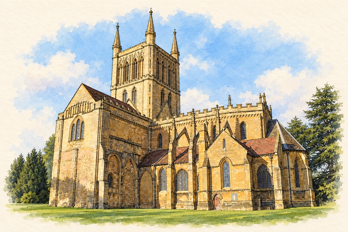
Watercolour and fine ink illustration of Pershore Abbey
Illustration · Pershore Abbey
History & heritage

Place & story

A town divided between abbeys

Pershore’s medieval development was shaped by competing monastic ownership. Edward the Confessor transferred part of Pershore Abbey’s estates to Westminster Abbey in 1065. Broad Street marks the division: much of the High Street remained with Pershore, while Bridge Street and the southern area passed to Westminster. Different property holdings and borough rights influenced where trading space and house plots developed. [3]

The grand houses visible along the main streets are a later layer over that older plan. Behind them survive smaller cottages, yards, workshops, barns and stables. These backland spaces explain something the formal Georgian frontages can conceal: Pershore combined prosperous households with the storage, production and service work of a market town. [3]

Keeping part of a monastery

The Norman abbey church was completed in 1130, then repeatedly damaged and rebuilt. Fire destroyed the eastern part in 1223; another fire in 1288 damaged the tower and quire roof. The distinctive ploughshare vaulting belongs to the rebuilding around 1300. The present church records successive responses to disaster rather than a single building campaign. [2]

When the monastery was dissolved in 1540, the town saved its east end, crossing and tower. The north transept fell in 1686, reducing the surviving structure further. Later restorations and structural repairs made continued use possible; the Friends of Pershore Abbey, formed in 1932, helped fund building work. Care for a parish church became part of the abbey’s history after monastic life ended. [2]

A working riverfront

Bridge Street connected accommodation, storage and river carriage. Buildings at numbers 37–43 originated as the Maidenhead Inn and a landing place for barges. The later Brandy Cask premises had been a wool warehouse. Alongside the picturesque street were practical arrangements for travellers and merchandise, with the Avon providing access to a wider trading system. [4]

The old bridge also records disruption. Charles I’s retreating army attempted to destroy it in 1644; repairs to the centre arch remain visible in the differing stonework. Its medieval fabric has been repeatedly altered, making the crossing a record of repair and conflict as well as a connection between the town and its hinterland. [4]

Growing for a national market

From the late nineteenth to the mid-twentieth century, market gardens and orchards reshaped communities around Pershore and Evesham. Fruit, vegetables, herbs and flowers went to distant markets by rail and later by lorry. The work supported transport firms, basket makers, blacksmiths and preserving factories, including Pershore’s Pomona Jam Factory. Growing produce sustained connected trades beyond the garden itself. [5]

Family labour mattered alongside hired workers. The county archive’s exhibition describes women planting, picking and packing while running households, and children helping after school and during holidays. Letters written by Pershore and Badsey schoolchildren in 1933 preserve descriptions of tying onions, fruit picking and long working days. They place children’s own accounts beside the more formal records of crops and sales. [5]

Back to contents
Lives connected to this place

Notable people

George Perrott: investing in the Avon

Judge George Perrott retired to Pershore and built Perrott House around 1770. He restored the Avon navigation’s weirs and locks, connecting a prominent private residence with investment in river infrastructure. Stanhope House, built around 1790, belonged to his nephew, another George Perrott. [4]

David Eric Tower: a grower in the records

The county archive identifies David Eric Tower as a grower who moved from Leicestershire to Pershore between the 1901 and 1911 censuses. By 1911 he lived at The Hill and described his occupation as market gardener. A surviving leaflet offered Pershore plums from Pershore and identified him as a Fellow of the Royal Horticultural Society. His Oxford education and private means show that growers entered the trade from differing backgrounds. [6]

Tower died in 1944, describing himself as a retired market gardener. The county archive recovered his story through an advertisement and documentary research. It offers a precisely located individual example within the town’s horticultural history, without treating his circumstances as typical of all the families who depended on seasonal growing. [6]

Back to contents
A chronology

Timeline

Pershore through time

  1. 1065 — Part of Pershore Abbey’s estates passes to Westminster Abbey. [3]

  2. 1130 — The Norman abbey church is completed. [2]

  3. 1540 — The town retains part of the church after the monastery closes. [2]

  4. 1644 — Royalist troops attempt to destroy the old bridge. [4]

  5. Around 1770 — George Perrott builds his house in Pershore. [4]

  6. 1932 — Friends of Pershore Abbey forms to support the building. [2]

  7. 1933 — Pershore and Badsey schoolchildren write accounts of work on the land. [5]

Back to contents

Population over time

Built-up area · Settlement · Census 2021

Pershore

8,210people · 2021

Census 2021 population of the named settlement, using ONS built-up area boundaries.

Published census counts.

Sources: ONS: Towns and cities, characteristics of built-up areas, Census 2021 (Table 1c)

View population figures
Pershore — census population
Census yearPopulation
20218,210
Sources and how to read this chart

Usual residents on 21 March 2021; published ONS count rounded to the nearest 5.. Boundary geography: December 2022 (E63003697).

Census 2021 population of the named settlement, using ONS built-up area boundaries.

ONS Table 1c rounds counts to the nearest 5 and suppresses counts below 10. Matched by exact settlement name or individually reviewed district-qualified name, with its coordinate strictly inside that same official BUA boundary. The 2022 BUA geography changed methodology and cannot be directly compared with 2011 BUAs. Contains OS data © Crown copyright and database right 2026. Contains National Statistics data © Crown copyright and database right 2026.

Source: ONS: Towns and cities, characteristics of built-up areas, Census 2021 (Table 1c). Open Government Licence v3.0. Retrieved 2026-10-26. Source: ONS and Ordnance Survey: Built Up Areas December 2022 GB BGG. Open Government Licence v3.0. Retrieved 2026-10-26.

Neighbourhood census context

These figures describe statistical neighbourhoods, which may cover part of a place or include neighbouring places.

Neighbourhood census area · 1971–2021

Wychavon 012

Population of the area containing the recorded point for Pershore, not the whole place. This area may cover part of the place or include neighbours.

02.3k4.5k6.8k9k1971: 5,586 people19711981: 6,975 people19811991: 7,129 people19912001: 7,326 people20012011: 7,039 people20112021: 8,401 people2021

Includes harmonised historical census estimates.

Sources: ONS · Paul Norman

View population figures
Wychavon 012 — census population and harmonised historical estimates
Census yearPopulation
19715,586
19816,975
19917,129
20017,326
20117,039
20218,401
Sources and how to read this chart

Usual residents of the containing MSOA; this is local area context, not the population of the named settlement.. Boundary geography: 1 April 2022 (E02006759).

2011 and 2021 census counts harmonised by ONS to the same 1 April 2022 geography. Location matched to ONS 2021 MSOA polygons (full resolution, coastline clipped, V7). ONS exact-fit lookup marks this MSOA unchanged from 2011 (U); historical estimates use that same footprint.

1971–2011: Paul Norman harmonised historical estimates on 2011 MSOAs, rounded to whole residents (1971–1991 are modelled). 2021: ONS census count. The historical 2011 total can differ slightly from the ONS change-over-time 2011 total because of methodology and statistical disclosure controls. These are area estimates, not settlement totals.

Source: ONS Census change over time: usual resident population, 2011 and 2021. Open Government Licence v3.0. Retrieved 2026-10-26. Source: ONS MSOA December 2021 boundaries EW BFC V7. Open Government Licence v3.0. Retrieved 2026-10-26. Source: Paul Norman — Area characteristics: Great Britain 1971 to 2011. Creative Commons Attribution 4.0. Retrieved 2026-10-26. Source: ONS MSOA 2011 to MSOA 2021 exact-fit lookup for England and Wales. Open Government Licence v3.0. Retrieved 2026-10-26.

Recorded locationPershore52.11164° N · 2.07570° WInteractive map loads when this area enters view.
Approximate recorded location · Geographic source

Geographic context

Place type
Town
Country / region
England · West Midlands
County group
Worcestershire
Current administration
Wychavon
Current administration
Worcestershire
Recorded coordinates
52.11164, -2.07570
OS Open Names ID
osgb4000000074578296

County groups are browsing aids. Current administrative and historic areas are recorded separately.

Recorded names

  • Pershore · en · official

Nearby heritage

Explore recorded heritage in Pershore and the surrounding area. This selection is based on proximity to a recorded settlement point; it is not a complete inventory or evidence that a site lies within the settlement or belongs to its history.

Heritage locationsPershore & surrounding areaInteractive map loads when this area enters view. Source records are listed below.

Numbered markers match the source records below. Locations are recorded reference points, not site boundaries.

  1. 52, HIGH STREET · Listed building
  2. 45, HIGH STREET · Listed building
  3. 47, HIGH STREET · Listed building
  4. 54, HIGH STREET · Listed building
  5. 49 AND 51, HIGH STREET · Listed building
  6. 53, HIGH STREET · Listed building
  7. 56, HIGH STREET · Listed building
  8. 41 AND 43, HIGH STREET · Listed building

Sources & further reading

  1. OS Open Names October 2026 · Source licence.
  2. About Pershore Abbey · Pershore Abbey
  3. Pershore Conservation Area Appraisal · Wychavon District Council
  4. Pershore Town Walk · Pershore Civic Society
  5. Grown in the Vale · Worcestershire Archive & Archaeology Service
  6. David Tower, Pershore Plums from Pershore · Worcestershire Archive & Archaeology Service
  7. Illustration of Pershore Abbey, adapted from Pershore Abbey - geograph.org.uk - 1057540.jpg by Philip Halling. CC BY-SA 2.0. AI-assisted watercolour and fine ink adaptation; cream paper margins, simplified fine detail and removal of incidental street clutter.

Geographic source retrieved 2026-10-26. History last researched 2026-10-27. How this page was prepared.